 |
|
Photos
View |
|
All Photos |
Add Photos |
Emoticons |
Album View |
Mark Unread
|
|
|
|
|
|
|
|
|
|
|
|
|
|
|
|
|

Click on photo to view the original size. |
| Viewers
|
|
|
|
|
|
|
|
|
|
|
Read what others had to say:
|
|
|
|
|
|
|
 |
Don Maxwell - Jan 16,2008
Viewers
| Reply
|
| |
Bruno, what the heck do all those little black squares represent? If they aren't airports or inhabited lakes, then I'd probably think about following the main roads. 300 miles isn't far, but it would seem a lot farther to me over unbroken forest. If the squares represent elevation, wouldn't you want to mark the high points, not the low ones? And if they're just little black squares--well, will you be able to see them as you're flying overhead?
| | |
|
Bruno Grondin - Jan 16,2008
Viewers
| Reply
|
| |
Hey Don,<br />Theses squares represent each legs I made the virtual trip by following the water strips so each angles change is attatche by a square.<br />This way it will be a safe trip, always water ahead and under...<br />I want to make the trip from my place to the Gaggle A TRIP so if I want to see things I will simply take a room during the voyage and leave the next morning for Gaggle. Thats the real meanning of owning a Searey hey..?
| | |
|
Dennis Vogan - Jan 16,2008
Viewers
| Reply
|
| |
Hey Bruno, I took the straight line approach at 8500 ft as I chant, 'Altitude is my freind!' The last stretch is over nothing but forest and lakes. It's cool up there (in more ways than one!).
| | Attachments:
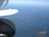
DSC00220
| |
| Attachments:
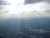
DSC00238
| | |
|
Bruno Grondin - Jan 17,2008
Viewers
| Reply
|
| |
Wow nice photo Dennis, but I prefer low and slow, I know its more risky, but I dont want the feeling of beiing in a airbus 320....<br />As you can see I follow water the friendly element for me and NIA....<br />Dennis the only tough of doiing this make me beat my hearth its the reason the reason...of all this....
| | |
|
Steve Gromak - Jan 17,2008
Viewers
| Reply
|
| |
I agree with you Bruno, I like it low and slow too. I only have one reason to go up high and that's to get away from the mid-afternoon thermo's.
| | |
|
Don Maxwell - Jan 17,2008
Viewers
| Reply
|
| |
Right, Bruno. And anyway, Dennis can't possibly see those little black squares from a mile and a half up.
| | |
|
|
|
|
|
|
|
|
|
|
| |
- About Searey.us -
- Contact Searey.us -
|
- Privacy Statement -
- Terms of service -
|
Copyright © 2024 Searey.us & Brevard Web Pro, Inc. -
Copyrights may also be reserved
by posters and used by license on this site. See Terms of Service for more information.
|
| |
- Please visit our NEW
Chapter Place Website at: chapterplace.com or
Free Chapter Management Website at: ourchapter.org. Good for all chapters, groups or families. |
| | |