|
|
 |
|
|
|
|
|
|
|
|
|
|
|
|
|

Click on photo to view the original size. |
| Viewers
|
|
|
|
|
|
|
|
|
|
|
Read what others had to say:
|
|
|
|
|
|
|
 |
Dan Nickens - Oct 26,2011
Viewers
| Reply
|
| |
In less than an hour the decision to launch was endorsed by blue skies and vast plains full of oil wells.
| | Attachments:
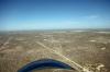
Oil Plains
| | |
|
Frank A. Carr - Oct 26,2011
Viewers
| Reply
|
| |
Bet it was bumpy!
| | |
|
Dan Nickens - Oct 26,2011
Viewers
| Reply
|
| |
I can confirm that.
| | |
|
Dan Nickens - Oct 26,2011
Viewers
| Reply
|
| |
Good news for gasoline engines: the wells were pumping and lots of new ones were being drilled.
| | Attachments:
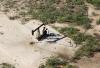
Pumping Oil
| | |
|
Dan Nickens - Oct 26,2011
Viewers
| Reply
|
| |
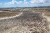
Out in the scrubland there was an occasional patch of sand that would make a great playground for kids, if there were any around, and there weren’t.<br /><br />The dunes extend northward and into New Mexico. Most are stabilized by vegetation, but some, up to 70’ high, aren’t. The sand piles up against the Llano Estacado, one of the largest mesas on the North American continent.<br />
| | Attachments:
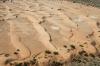
Sand Patch1
| | |
|
Dan Nickens - Oct 26,2011
Viewers
| Reply
|
| |
The tracks indicate that cows like to play in the dunes. Cow tipping on the dunes would be extra fun for those that like that kind of thing.<br /><br />There is shallow groundwater under the dunes. Native Americans used the area for camping and meetings until the 1880s when the railroad moved in. Acorns, mesquite beans and game were plentiful. Oil rigs arrived 1920’s, tapping into the rich Permian basin.<br />
| | Attachments:
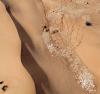
Sand Patch2
| | |
|
Dan Nickens - Oct 26,2011
Viewers
| Reply
|
| |
A big hole in the ground is not necessarily a meteor crater. It’s not immediately clear how it was mined, however, since the walls were vertical and caving. Not so far away in Odessa, Texas there is a well known meteor crater. And another, the Sierra Madera crater, is located south of Stockton.
| | Attachments:
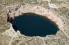
Not Meteor Crater
| | |
|
Kenneth Leonard - Oct 26,2011
Viewers
| Reply
|
| |
I think that's the sinkhole that got my 401k.
| | |
|
Dan Nickens - Oct 26,2011
Viewers
| Reply
|
| |
I'm not so sure, Ken. It wasn't that big!
| | |
|
Dan Nickens - Oct 26,2011
Viewers
| Reply
|
| |
The town of Wink had a very unconventional Fixed Base Operation. First, it was only attended by the friendly dog. Second, it was self service for fueling but there was no provision for immediate payment. You were asked to leave a note with name, address, and contact information. The dog watched patiently to make sure it was all done. Afterwards, he turned around and went back to his blanket just inside the hangar door to resume his watch.<br /><br />Winkler County (“KINK”) was only about 160 miles from San Angelo. In a straight line (yes, it was straight…well, mostly), it still took two hours. Not a good average for making it to LA on time.<br />
| | Attachments:
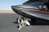
Unconventional FBO
| | |
|
Dan Nickens - Oct 26,2011
Viewers
| Reply
|
| |
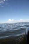
If a seaplane splashes down on a deserted lake and no one sees, is it a permitted use? There was no guidance from the SPA Water Landing Directory and there was no signal for the iPad to check the Texas SPA site. The deciding factor: there was no one in sight to object.
| | Attachments:
Deserted Splash
| | |
|
Dan Nickens - Oct 26,2011
Viewers
| Reply
|
| |
It has to be legal if it is too brief for anyone to see.
| | Attachments:
Legally Brief
| | |
|
Dan Nickens - Oct 26,2011
Viewers
| Reply
|
| |
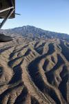
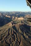
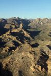
When the plains start to crack up, something big is about to appear.
| | Attachments:
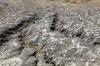
Cracks in the Plains
| | |
|
Dan Nickens - Oct 26,2011
Viewers
| Reply
|
| |
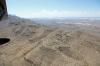
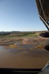
Instead of the table flat plain with nothing but sage brush and oil wells, the ground got a bit rugged for an uneventful emergency landing.
| | Attachments:
Rough Runway
| | |
|
Dan Nickens - Oct 26,2011
Viewers
| Reply
|
| |
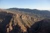
The Guadalupe Mountains rose up in the windscreen to be climbed. That included the highest peak in Texas, Guadalupe Peak, with an elevation of 8750’ just off the port wing.<br /><br />The Guadalupe Mountains are the edge of the great Delaware Basin. The large, shallow inland sea collected some great sediments to collect oil from all the dead little critters swimming in its warm waters. A wide spread uplifting of the crust cracked the earth, lifting the reefs of the Guadalupe Mountains up to their present lofty position, giving the little Rotax turbocharger a good workout.<br />
| | Attachments:
Rising Ground
| | |
|
Dan Nickens - Oct 26,2011
Viewers
| Reply
|
| |
After crossing the peaks, it’s downhill on the slopes of the Brokeoff Mountains into the salt flat. The Brokeoff Mountains have nothing to do with a Brokeback Mountain (but just in case I didn’t look for a landing spot).
| | Attachments:
Downhill Run
| | |
|
Tim Jones - Oct 26,2011
Viewers
| Reply
|
| |
Good decision making skills,
| | |
|
Dan Nickens - Oct 26,2011
Viewers
| Reply
|
| |
Sometimes. On some matters.
| | |
|
Dan Nickens - Oct 26,2011
Viewers
| Reply
|
| |
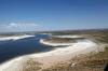
Intermountain lakes aren’t always that great for splashing.
| | Attachments:
Flat and Salty
| | |
|
Dan Nickens - Oct 26,2011
Viewers
| Reply
|
| |
Sometimes the outside of a volcanic cone gets stripped away by the weather leaving just a rocky core. These igneous rocks rose up through the surrounding sedimentary rocks, now long since washed away. There are said to be thousands of Apache carvings of their deities on the rocky slopes of Cornudas Mountain. I didn’t have time to stop and check.
| | Attachments:
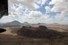
Old Core
| | |
|
Dan Nickens - Oct 26,2011
Viewers
| Reply
|
| |
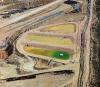
The great thing about living in the desert is never having to mow grass…unless you plant and water it.
| | Attachments:
Artificial Grass
| | |
|
Don Maxwell - Oct 27,2011
Viewers
| Reply
|
| |
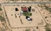
Bizarre. I wonder if they think that chain link fence will keep the desert out. The whole lot is laid out as if it were in a Midwestern town--as if they had some vision of 'home' that clashes with their present location.<br /><br />At first I thought there were two sunbathers in the back yard, but maybe it's just some lumber lounging on a table.
| | |
|
Dan Nickens - Oct 26,2011
Viewers
| Reply
|
| |
Nice yard with a great play place for some kid who would probably like to be anywhere but at home.
| | Attachments:
Desert Playground
| | |
|
Don Maxwell - Oct 27,2011
Viewers
| Reply
|
| |
These shots shore make y' wonder about us humans and our idea of home.
| | |
|
Dan Nickens - Oct 26,2011
Viewers
| Reply
|
| |
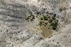
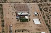
Someday this could grow up to be a forest in the desert?
| | Attachments:

Future Grove
| | |
|
Dan Nickens - Oct 26,2011
Viewers
| Reply
|
| |
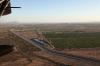
The Rio Grande River is just a sandy canal as it passes through Las Cruces.
| | Attachments:
Rio Grande Canal
| | |
|
Dan Nickens - Oct 26,2011
Viewers
| Reply
|
| |
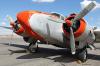
A weary looking Lockheed PV-2 Harpoon was waiting next to an open parking spot at the Las Cruces airport (KLRU). It took 3.1 hours to get from San Angelo, a distance covered of about 225 miles. Much of that was either climbing or descending into a serious headwind.
| | Attachments:
Weary Warrior 1
| | |
|
Dan Nickens - Oct 26,2011
Viewers
| Reply
|
| |
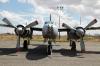
Not far from the Harpoon sat a Douglas A-26B. Sometime after its military service it was converted for executive transport. Leaving the guns in the nose gives a whole new meaning to “hostile takeover” in the corporate world.<br /><br />The kind offer of a crew car let me leave the vending machine behind in search of a quick lunch. That was found next to a bull riding concession and kids fair by I-10.<br />
| | Attachments:
Corporate Raider
| | |
|
Dan Nickens - Oct 26,2011
Viewers
| Reply
|
| |
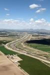
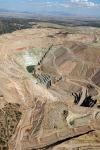
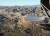
Between the faulted basins to the south and volcanic complex to the north, granitic intrusions forced their way up. Highly mineralized water boiled up and cooled in the surrounding sediments. The minerals precipitated out of solution leaving low grade ores of gold, silver, and copper. At Tyrone, there is enough concentration to make for New Mexico’s second largest copper mine.
| | Attachments:
Big Dig
| | |
|
Dan Nickens - Oct 26,2011
Viewers
| Reply
|
| |
Pretty (toxic) ponds! The native Americans mined turquoise here before the non-native American big diggers came after copper. Apparently there is still turquoise in the cool water ponds..at least the color is still there.
| | Attachments:
Copper Ponds
| | |
|
Dan Nickens - Oct 26,2011
Viewers
| Reply
|
| |
The copper mine really shines in late afternoon sun.
| | Attachments:
Big Dig 2
| | |
|
Dan Nickens - Oct 26,2011
Viewers
| Reply
|
| |
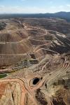
Drought is a long term condition in the desert. When it does rain, however, the drainage runs into the Gila River. Left alone it would be a perennial river with plenty of volume. Back in the day it was navigable from the Colorado River all the way to the Arizona, New Mexico border (that before it was drained dry by users). At one time it was the border between the U.S. and Mexico.
| | Attachments:
Long Term Dry
| | |
|
Dan Nickens - Oct 26,2011
Viewers
| Reply
|
| |
The SeaRey is right at home in the desert at the Safford airport (KSAD). I would have liked to stay the night so I could visit the observatories outside of town. The Mount Graham International Observatory is operated by the University of Arizona. In support of its operation, Safford uses low intensity lights for city streets.<br /><br />There was no time for such casual observations, though. I’d only covered another 160 miles in the last 2.3 hours. Even allowing for mountain climbing and mine circling, that was a poor 70 mph average.<br />
| | Attachments:
Desert Seaplane
| | |
|
Dan Nickens - Oct 26,2011
Viewers
| Reply
|
| |
Wrinkled? Yes, but it’s probably just old. The peak is part of the Santa Teresa Mountains in the San Carlos Indian Reservation. Apaches were moved out into “Hell’s Forty Acres” in 1871. Their sympathetic agent and 10 Apache police officers captured Geronimo when the Army couldn’t. In a bureaucratic spat he was later released, and continued his raids for another 15 years.<br /><br />Hmmm....<br /><br />Ever hear about why people who jump out of airplanes yell “Geronimo” when they do it? I’ve often wondered about them…and why they yell that. When I went to do it I was told that it was because Geronimo was the bravest of the braves, and that was what it took to jump out of a fully functional airplane (I thought about yelling “Dobby Gillis” because I was thinking it took something other bravery.)<br /><br />Now I understand that during the 1940’s there was to be a mass test jump of the newly invented Army tactic. One guy was told he would be too scared to remember his name. He said he would remember, but since they had just shown “Geronimo” at the talkies, that’s what he’d yell. He did. It caught on. Go figure.<br /><br />It's probably only because they didn't have any Van Halen music.<br /><br />'I get up, and nothin' gets me down<br />You got it tough, I've seen the toughest around<br />And I know, baby, just how you feel<br />You got to roll with the punches and get to what's real<br /><br />Ah, can't you see me standin' here<br />I got my back against the record machine<br />I ain't the worst that you've seen<br />Ah, can't you see what I mean?<br /><br />Ah<br />Might as well jump<br />(Jump)<br />Might as well jump<br />Go ahead an' jump<br />(Jump)<br />Go ahead and jump'<br /><br />
| | Attachments:
Wrinkle Mountain
| | |
|
Dan Nickens - Oct 26,2011
Viewers
| Reply
|
| |
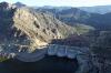
It was a lake, but a bit too low for comfort. Will Rogers attended the dedication of the associated dam and said, “If it was my dam, I’d mow it.” If it was my lake I’d have a SeaRey picnic on the banks. If I had time.
| | Attachments:
A Hint of Lake
| | |
|
Dan Nickens - Oct 26,2011
Viewers
| Reply
|
| |
This totally cracked up lake bottom didn’t need mowing.
| | Attachments:
Cracked Bottom
| | |
|
Dan Nickens - Oct 26,2011
Viewers
| Reply
|
| |
Three domes make a dam: Coolidge Dam. The Apache didn’t want the dam. Its water covered the old camp from which Geronimo made his raids. It also covered a burial ground. The Government offered to dig up the graves, but that seemed like a really bad idea to the Apache. Instead they agreed to have a concrete pad poured over the area. That, plus some water, should probably keep anything from crawling out on Halloween.
| | Attachments:
Triple Dam
| | |
|
Dan Nickens - Oct 26,2011
Viewers
| Reply
|
| |
Upturned limestone of the Mescal Mountains lies directly across the path of the Gila River. The ridges converge to form “Needles Eye” in the Needles Eye Wilderness Area. Or maybe the ridges were simply cut in two by the river. Yep, that’s it.
| | Attachments:
Tilted View
| | |
|
Dan Nickens - Oct 26,2011
Viewers
| Reply
|
| |
What looked like a pretty good emergency landing area turned out to have plenty of large Saguaro Cactus. That got me to thinking of all the crash landings into cactus that the Coyote had on the Roadrunner Show. Repeating that experience was not a pleasant thought.
| | Attachments:
Sticking Points
| | |
|
Kenneth Leonard - Oct 27,2011
Viewers
| Reply
|
| |
Isn't that what you call 'sticking' the landing?
| | |
|
Dan Nickens - Oct 26,2011
Viewers
| Reply
|
| |
This lake wasn’t particularly tempting for SeaRey splashing. There used to be a town called Sonora here. Now it’s a copper mine.
| | Attachments:
Mountain Lake
| | |
|
Don Maxwell - Oct 27,2011
Viewers
| Reply
|
| |
A copper mine, eh. Interesting terraced dams and pools.
| | |
|
Dan Nickens - Oct 26,2011
Viewers
| Reply
|
| |
The late afternoon sun highlighted the cliffs and canyons of the White Canyon Wilderness Area. Sheer walls, black bears, mountain lions, flash floods, human and drug trafficking all make it a bit wilder than many other wilderness areas. Perhaps it is best viewed from above by SeaRey.
| | Attachments:
Highlighted Cliffs
| | |
|
Dan Nickens - Oct 26,2011
Viewers
| Reply
|
| |
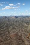
The borders of the broad valley holding Phoenix looked pretty rough.
| | Attachments:
Tough Territory
| | |
|
Dan Nickens - Oct 26,2011
Viewers
| Reply
|
| |
The brown of the desert is made green by water from the canals. Despite being in the desert (or maybe because of it) there has been a century of preparation for drought conditions. An Arizona law requires that sustainable use of groundwater be obtained by 2025. In the meantime, no new development is approved unless it can show sustainable water under normal conditions for 100 years. Phoenix already recycles 90% of its wastewater. It is ready for drought with surface water from the Salt River and Verde River water system managed through a system of reservoirs and canals and surface water from the Colorado River via the Central Arizona Project canal.<br /><br />The Holokam worked the same system in the same place for 1000 years. Sometime between 1300 and 1450 drought and severe flooding caused them to abandon the area.<br />
| | Attachments:
Green Desert
| | |
|
Dan Nickens - Oct 26,2011
Viewers
| Reply
|
| |
After a long time in the mountains, a late afternoon landing in the broad flats of the Chandler airport seemed too easy. Phoenix lies in a basin between mountain ranges. The mountains would be even more dramatic if the basin had not filled with sediments for the past many millions of years.<br /><br />Touchdown at Chandler was only 1.8 hours and 140 miles from Safford. It didn’t matter because the sun was getting low and there was no place west of Phoenix within SeaRey reach during daylight. And after 10 hours of fine flying Pia needed a rest.<br />
| | Attachments:
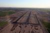
Nice and Flat
| | |
|
Frank A. Carr - Oct 27,2011
Viewers
| Reply
|
| |
After 10 hours of flying Dan, do you still feel like the slow speed of the SR is best since it <br />gives you more time in the air?
| | |
|
Dan Nickens - Oct 27,2011
Viewers
| Reply
|
| |
No way, Frank. If the light had held up we'd gotten another two or three hours. But, I could have gotten there faster except for an inability to follow the nice straight line on the GPS and my secondary assignment (making the pictures). If I could have plausibly have told Adam that the trip would take a minimum of three weeks, I'd have gone even slower! (Unfortunately he has a flight planner on his computer that knows nothing about what's outside the straight line between airports.)
| | |
|
Bill Walker - Oct 27,2011
Viewers
| Reply
|
| |
Really enjoying the trip. If you need someone to help bring PR back, please let me know.<br />Bill
| | |
|
Dan Nickens - Oct 27,2011
Viewers
| Reply
|
| |
So sorry, Bill, but it's back and gone again since this trip (but that's all postings pending).
| | |
|
|
|
|
|
|
|
|
|
|
|
| |
- About Searey.us -
- Contact Searey.us -
|
- Privacy Statement -
- Terms of service -
|
Copyright © 2024 Searey.us & Brevard Web Pro, Inc. -
Copyrights may also be reserved
by posters and used by license on this site. See Terms of Service for more information.
|
| |
- Please visit our NEW
Chapter Place Website at: chapterplace.com or
Free Chapter Management Website at: ourchapter.org. Good for all chapters, groups or families. |
| | | | | | | | | | | | | | | | | | | | | | | | | | | | | | | | | | | | | | | | | | | | | |