|
|
 |
|
|
|
|
|
|
|
|
Posted By:
Hal Brown
Date Posted:
Feb 12, 2012
Description:
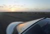
Loreto was an exercise in frustration. The guys with the M-16s didn’t understand my broken Spanish. The entry inspection was going badly until I remembered my handy printout of commonly asked questions and answers for suspicious looking Gringo pilots.
“Bueno!”
Then I went directly to the weather guy to check on the fog forecast, but that was the wrong sequence of events: first I had to pay. But I couldn’t pay the airport operator because I hadn’t fueled. I couldn’t get fuel because the fuel guy was on break, so I just self fueled. Wrong. The fuel guy was not a happy camper, but neither was I. When he pointed to the tip jar, I had one for him, but fortunately he didn’t understand…or at least he didn’t tell the aviation guy (probably because he was AWOL from the fuel pump). Then the operator told me I could pay for the fuel with a credit card, but I had to pay the tower guy in cash.
Whatever. By the time I got back to the weather guy I was told that Guerrero Negro wasn’t reporting weather. Didn’t I know it was always cold, windy and foggy?
Great. There was nothing left to do but launch and go see for myself!
Date Taken:
Feb 12, 2012
Place Taken:
Loreto, Baja California Sur, MX
Owner:
Dan Nickens
File Name:
Leaving_Loreto.jpg - Photo HTML
Full size - <img src="/show.php?splash=SZOIE0000h">
Medium - <img src="/show.php?splash=SZOIE0000m">
Thumbnail - <img src="/show.php?splash=SZOIE0000s">
Category:
497, Yacht Tending Baja
|
|
|
|
|

Click on photo to view the original size. |
| Viewers
|
|
|
|
|
|
|
|
|
|
|
Read what others had to say:
|
|
|
|
|
|
|
 |
Dan Nickens - Feb 12,2012
Viewers
| Reply
|
| |
Loreto is located in a marine tectonic basin. The area around it dropped as a block, forming an embayment. The Cenozoic age embayment filled with sediments from erosion and volcanism. It is crisscrossed with faults and has been folded along a north to south axis. It is one of the few tectonic basins in Baja sur.<br /><br />The town was once the capital city of Baja. In 1829 a hurricane devastated the city and the capital moved south to La Paz. That was not the first or last time the town got flooded. The normally dry Arroryo Las Parras has destroyed the town at least eleven times. And that doesn’t count the large 1877 earthquake.<br /><br />Loreto can still claim to be the oldest continuously inhabited (by Europeans) town on the peninsula. Cortez established a small colony in 1535. That was abandoned just two years later, but Cortez had a good excuse. He wasn’t trying to settle down. He was really hunting for the mythical land of Calafia. Calafia was believed to be an island west of Spain occupied by large “Amazon” women (known as “Gigantis”). The main attraction wasn’t the women, however, it was the gold and jewels they owned. As we know now, Calafia wasn’t an island. It is a suburb of Los Angeles now known as Hollywood, California (or Hollywood, Calafia if you’re really hip).<br /><br />It took a higher purpose than women with gold to make Loreto a permanent place. Padre Juan Maria Salvatierra landed in 1697 with six soldiers to establish a mission (Mision Nuestra Senora De Loreto). It’s been continuously occupied by Europeans since then.<br /><br />It was inhabited by me for far too long! (Or maybe not long enough? It just might depend on weather developments at the other end of the flight.)<br />
| | Attachments:
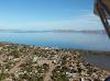
Downtown Loreto
| | |
|
Dan Nickens - Feb 12,2012
Viewers
| Reply
|
| |
Following the water is usually the safest course in a SeaRey. The calm waters of the Gulf were definitely an attraction. I had to weigh that security against the insecurity of the bad weather possibilities. I decided to follow the road. Off road did not look very inviting.
| | Attachments:
Off Road
| | |
|
Dan Nickens - Feb 12,2012
Viewers
| Reply
|
| |
Having elected to follow the road, I quickly found there was no easy path back to the coast.
| | Attachments:
Terra Firm Boundary
| | |
|
Dan Nickens - Feb 12,2012
Viewers
| Reply
|
| |
The waterway could still make a good place to set down softly in an emergency. Yes, the water was long gone, but it left a few flat, sandy spots.
| | Attachments:

Soft Places
| | |
|
Dan Nickens - Feb 12,2012
Viewers
| Reply
|
| |
Eventually a way back to the coast appeared. The way straight ahead, however, offered a hope of water without a big diversion. There were only a few hills to cross first.
| | Attachments:
Way Out
| | |
|
Dan Nickens - Feb 12,2012
Viewers
| Reply
|
| |
The road made a turn, but there was a big bay ahead. It looked like a good excuse to take a scenic short cut.
| | Attachments:

Bay Ahead
| | |
|
Dan Nickens - Feb 12,2012
Viewers
| Reply
|
| |
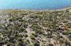
Getting down to the bay meant crossing some really prickly ground.
| | Attachments:
Down to the Shore
| | |
|
Dan Nickens - Feb 12,2012
Viewers
| Reply
|
| |
Down by the shoreline it was a lot flatter without the prickly cacti.
| | Attachments:
Near Shore
| | |
|
Dan Nickens - Feb 12,2012
Viewers
| Reply
|
| |
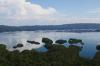
The south end of the bay was the start of a 25 mile trek to get back to the road.
| | Attachments:
Bay End
| | |
|
Dan Nickens - Feb 12,2012
Viewers
| Reply
|
| |
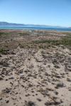
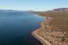
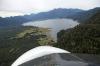
Bahia Concepcion is known not only for its fish, but also for its clear (mostly) blue water. The turquoise blue water color is enhanced by colloidal lime dissolved from shells and skeletons of millions of calcareous marine creatures.
| | Attachments:
Back Bay
| | |
|
Dan Nickens - Feb 12,2012
Viewers
| Reply
|
| |
The bay is bracketed by hills. It makes for stark contrasts between the water, the beach, the dunes, the cacti, and the mountains over short distances.
| | Attachments:
Canyon Beside the Bay
| | |
|
Dan Nickens - Feb 12,2012
Viewers
| Reply
|
| |
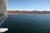
The connection with the Gulf is pretty narrow for a 25 mile long bay.
| | Attachments:
One Way Out
| | |
|
Dan Nickens - Feb 12,2012
Viewers
| Reply
|
| |
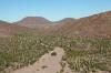
For such a brown country there was a lot of tall green by the bay. The south end of the bay has one of the densest cactus forests in Baja.
| | Attachments:
Shoreside
| | |
|
Dan Nickens - Feb 12,2012
Viewers
| Reply
|
| |
With no time to stop and explore, it was necessary to get close and personal for cactus viewing.
| | Attachments:
Cruising the Shore
| | |
|
Dan Nickens - Feb 12,2012
Viewers
| Reply
|
| |
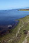
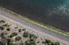
A brilliant green line made the shore line easy to track.
| | Attachments:
Bright Green Line
| | |
|
Dan Nickens - Feb 12,2012
Viewers
| Reply
|
| |
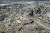
A small village sat on the landward side of the bay at its mouth.
| | Attachments:
Bayfront Village
| | |
|
Dan Nickens - Feb 12,2012
Viewers
| Reply
|
Dan Nickens - Feb 12,2012
Viewers
| Reply
|
| |
Little houses made of concrete, little house all in colored rows.
| | Attachments:

Colorful Living
| | |
|
Frank A. Carr - Feb 13,2012
Viewers
| Reply
|
| |
Could be a bit tough finding the right home under some situations.
| | |
|
Lee Coulman - Feb 14,2012
Viewers
| Reply
|
| |
Ticky tacky little boxes on the hillside.<br />Is this a time share neighbourhood or parking share?
| | |
|
Dan Nickens - Feb 14,2012
Viewers
| Reply
|
| |
I'm guessing they are 'en primeros' (or 'In Firsts'). At least that's what they look like based on the description I got back in 2007.
| | |
|
Chris Vernon-Jarvis - Feb 15,2012
Viewers
| Reply
|
| |
Wouldn't want to come home drunk on a dark night.
| | |
|
Dan Nickens - Feb 12,2012
Viewers
| Reply
|
| |
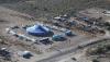
The circus is in town! A great place to spend the winter for the elephants.
| | Attachments:
Big Top
| | |
|
Dan Nickens - Feb 12,2012
Viewers
| Reply
|
Dan Nickens - Feb 12,2012
Viewers
| Reply
|
| |
It’s not much, but it looks like it would be fun.
| | Attachments:
Simple Stuff
| | |
|
Dan Nickens - Feb 12,2012
Viewers
| Reply
|
| |
The road turned inland. It was the flattest place to cross over.
| | Attachments:
Going Inland
| | |
|
Dan Nickens - Feb 12,2012
Viewers
| Reply
|
| |
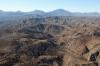
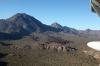
Volcan las Tres Virgenes was a line of volcanic cones stretching to the coast (well, actually, it’s probably just one big composite volcano but it’s usually better to have three virgins than just one). The last time the volcano is thought to have been active was in the early part of the 18th century, but no one is sure because there wasn’t any one around to report it. I didn’t see anyone except me that could report it going off on this date!
| | Attachments:
Line of Fire
| | |
|
Dan Nickens - Feb 12,2012
Viewers
| Reply
|
| |
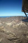
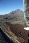
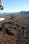
This lava flow didn’t get too far from its source.
| | Attachments:
Lava Lineage
| | |
|
Dan Nickens - Feb 12,2012
Viewers
| Reply
|
| |
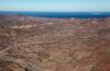
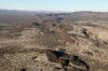
Wind-blown sand now fills the valleys of old lava flows.
| | Attachments:
Sand Filing
| | |
|
Dan Nickens - Feb 12,2012
Viewers
| Reply
|
| |
A quick glance at the clock was bad enough. Staring at the horizon it looked even worse. The hills barely hid a gray haze. Fog forming mists? I left the road to cut the corner. It didn’t take too long for the ground to show that any unscheduled landing would be of the rougher kind.
| | Attachments:
Dubious Deviation
| | |
|
Dan Nickens - Feb 12,2012
Viewers
| Reply
|
| |
Nibbling at the edges of the mountains, balancing time savings with the hope for a long enough glide out into the desert if the engine went quiet.
| | Attachments:
Ragged Edge
| | |
|
Dan Nickens - Feb 12,2012
Viewers
| Reply
|
| |
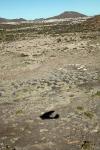
Finally some flats! Well, be careful what you wish for, eh? The soft, sandy desert floor was full of prickly cacti.
| | Attachments:

Finally Flat
| | |
|
Dan Nickens - Feb 12,2012
Viewers
| Reply
|
| |
If you like deserts, Desierto De Viscaino has a lot of it.
| | Attachments:
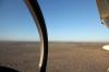
Nothing but Vast
| | |
|
Dan Nickens - Feb 12,2012
Viewers
| Reply
|
| |
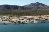
The military outpost at Guerrero Negro marks the 28th parallel and the boundary between Baja California (Norte) and Baja California Sur. The only road down the peninsula goes right through the middle of the post.
| | Attachments:
Misty Outpost
| | |
|
Dan Nickens - Feb 12,2012
Viewers
| Reply
|
| |
Uh, oh. The tell tale blurring of details out on the desert plain portended bad news: the fog was creeping in. The race was now clear and the fog had an advantage: the airport was right on the coast. Romeo Kilo rumbled across the desert at maximum continuous power in a shallow dive towards the unseen airport.<br /><br />I could just make out the huge Mexican flag marking the military base. The airport was just a few miles closer to the coast, hidden in the golden mist of a setting sun.<br /><br />It was not so golden when I arrived at the mythical point of the airport as shown on the GPS. I was over a gray cloud growing darker by the second as the sun sank below the horizon.<br /><br />I desperately looked for a gap in the fog that might show the ground. There was none. It was just a continuous blanket stretching far out into the sea, moving relentlessly inland.<br /><br />Determined to get on the ground before darkness was complete, I considered going off shore. “I’ll can make an instrument approach to the water, land, then taxi to shore. It’s just a couple of miles from the beach to the airport.”<br /><br />Then I remembered earlier encounters with Pacific swells. Even in calm wind, the ever present swell would surely smack the SeaRey right back into the mist. The image of being tossed out-of-control into a gray cloud quashed any further consideration of that plan.<br /><br />The sun was now fully set. Night flight without an instrument flight plan is not permitted in Mexico. Even if it were, there were no lighted airports within my fuel range. There were, however, several small gravel strips back in the desert. I reluctantly turned around and headed back towards the nearest.<br /><br />RK was going as fast as she could, but the fog seemed to be faster. It had an advantage. It was making a straight line inland. We were fighting the angles on a southeast heading.<br /><br />My first thought was to try for the airport at San Ignacio. The map showed a small village nearby. The GPS told me that it was an hour away. But it would be dark when I arrived at the unlit airport nestled in the foothills of the mountains. And, worse, it didn’t look very far from the coast. At the rate the fog was moving, it just might beat me there. Hmmm….fog in the foothills on a black night. That did not sound like an attractive prospect.<br /><br />The closest strip marked on the map was twenty minutes ahead. There were two airports within a few miles of the village of Vizcaino. Both were shown as unpaved and without lights. “That’s okay,” I postulated, as I should arrive just before the end of civil twilight.<br /><br />Romeo Kilo had no landing lights. There was no need for lights on a plane that only flew on pretty days in the bright sunlight. My hope was that there would be enough residual light to find the ground without wrecking the plane.<br /><br />With every passing minute that hope for an uneventful landing diminished with the light. At five miles out there was only a dim impression of the desert passing underneath. Details were impossible to see. Only the black pavement of the one road was visible against the desert sand.<br /><br />I arrived over the point the GPS showed the airport to be. From 500’ overhead, there was nothing but the dark desert with even darker spots of mesquite. The vague impression of a dirt runway was not convincing enough for a landing commitment.<br /><br />There were mere seconds to decide what to do. The last hint of light was only just lingering. There were no man-made lights for miles. The one truly significant visible feature was the darker pavement of the road. With only a brief pause, I turned to line up on the dark ribbon.<br /><br />The road was long and straight. I set up a gentle descent towards the coast along the dark line of the road.<br /><br />There was little warning of the approaching pavement: only a blur of darkness rushing past at an ever faster pace. There was no mistaking, however, its rejection of the wheels. The SeaRey bounced back up into the blackness. I gritted my teeth and held on.<br /><br />The second bounce wasn’t so bad. I could even vaguely see the black path of the road against the lighter desert with darker blotches of mesquite.<br /><br />I had almost relaxed when the SeaRey swerved as a wheel ran off the pavement. The wheels screeched as they slid back on to the pavement. The world swirled when the tail swung violently around in the other direction.<br /><br />It was all over in a moment. The airplane sat upright with the engine slowly idling, it’s nose perpendicular to the dim, dark line of pavement.<br /><br />I turned the engine off and opened the canopy. The metallic pings of the engine cooling were the only interruption of the soft rustling of the wind.<br /><br />Extinguishing of the cockpit lights, my night vision slowly improved. I could see nothing but vague impressions of scattered bushes and cacti.<br /><br />Getting out I walked around the front of the plane. It seemed to have survived my blind landing, or at least that was my impression from its stance. It was at a bit of an angle and I found out why when I stumbled into a shallow ditch.<br /><br />Behind the airplane was soft sand. I had not seen any traffic, but I decided I would try to pull the airplane off the road as far as possible. I strained to pick up the tail and walk it backwards between the bushes. I was nearly pushed over backwards when the main wheels rolled into the ditch.<br /><br />I shivered. The wind was cold. I went back to the cockpit and grabbed a sweat shirt, then sat on a wheel to think.<br /><br />The airplane was barely off the road, but I decided it could be avoided by traffic. Probably. I had no idea how far it was to the village. I decided I’d just have to wait for a motorist to come along.<br /><br />The minutes drug by. There was no traffic. I got the map out and turned on the GPS. As best as I could figure, I was just a mile or two from the airport and the village. The map showed both were down a side road.<br /><br />I had decided to try to walk to the village when I saw the headlights. I jumped up and watched warily as they grew closer.<br /><br />“A car! Excellent!”<br /><br />It didn’t seem so excellent as it barreled past. There was only the briefest swerve and the slightest slowing as it whisked by. The taillights quickly vanished into the enveloping darkness.<br /><br />That just didn’t seem right. Why wouldn’t anyone stop to see an airplane parked beside the road? Whatever the reason, it didn’t bode well for getting a ride. I decided to try to walk to the village.<br /><br />I grabbed a flashlight and started off walking down the side of the road. It only took a few stumbles to realize that the road wasn’t all that smooth. The middle was better.<br /><br />After about a mile I found an intersection. A faded sign pointed down a dusty gravel road towards Vizcano. It wasn’t far down that road until I found a dirt road leading into a cleared area. A broken wooden sign barely proclaimed “Aeropuerto de las Palomas”.<br /><br />So close! I almost had made it. Almost.<br /><br />It occurred to me that if I could move the airplane to the airport there would be less explaining to do in the morning. I turned and walked back the way I came.<br /><br />I arrived at the airplane without ever seeing any traffic. That encouraged me to think I might be able to taxi to the airport without getting run over. In the worst case I could turn off the pavement and into the desert. It wouldn’t be much worse than my present position. There was never any thought given to making the short flight. It was just too dark.<br /><br />The engine started easily. I turned on the position lights and pushed the throttle forward. The engine roared and the plane went nowhere. I turned the flashlight on my wheel and saw the reason. The soft sand in the shallow ditch had a firm grasp on it.<br /><br />Turning everything off, I climbed back out and began scooping the sand away with my hands. I cleared both wheels.<br /><br />Back in the cockpit, I tried again. I made a few inches progress before the sand again mounded against our efforts.<br /><br />This time, I decided I had to try and lift the wheels out of the sand to the edge of the road. Squatting under the struts, I lifted upward to raise the wheel. I could feel the bruising metal against my shoulders as the wheels barely moved. Again and again I strained to move an inch forward, one side at a time. Finally, sweat chilling in the cold breeze, the wheels rested against the crushed rock of the roadbed.<br /><br />With a lot of fervent encouragement, Romeo Kilo now surged out on to the pavement. There was no sign of traffic as we carefully trundled towards the dark intersection.<br /><br />I was beginning to think I had missed the turnoff when it dimly appeared. It took only a few minutes more before RK was legally parked beside a charted runway.<br /><br />With the massive wave of relief came a backwash of weariness. My plan of leaving the airplane and walking to the village seemed too big an effort. I decided I could just wait in the airplane until daylight would let me leave for my original destination.<br /><br />There was no comfortable position for sleep. It came anyway.<br /><br />The rumble of trucks woke me. I followed their lights from the road to the airport. A large van truck and a dark Suburban SUV stopped about 100 feet away with the SeaRey in their headlights.<br /><br />In a few minutes the passenger doors opened on the Suburban. Several men got out. They were carrying guns! I sat in the SeaRey frozen in the headlights.<br /><br />With at least three guns now pointed in my direction, one man walked hesitantly towards the SeaRey. I could only see his silhouette in the blinding light.<br /><br />He yelled something in Spanish. I just shook my head. He yelled again and thrust the gun menacingly towards me.<br /><br />I cracked the canopy, and replied, “No comprendo español.”<br /><br />He yelled something back to the truck. <br /><br />“Piloto?” he asked.<br /><br />“Sí,” I said.<br /><br />He waived his gun, motioning me out of the airplane. I didn’t move.<br /><br />There was a lot of intense conversation between the gunmen. I understood nothing. After some discussion, they took up positions around the airplane and the Suburban pulled in front, blocking any escape path.<br /><br />The other truck drove on past. Its occupants got out and began placing potable lights beside the runway.<br /><br />No one at the SeaRey moved. I certainly wasn’t going to do anything. A Mexican standoff looked like my best alternative. <br /><br />My adrenaline rush was just modestly subsiding when a bright spotlight appeared just above the horizon. The whine of a turbine rapidly grew in intensity. The gunmen holding the SeaRey hostage moved away from the runway but kept their guns trained on me.<br /><br />In moments a Caravan appeared, touching down on the runway just beyond the Suburban. There was more yelling between the gunmen as the Caravan taxied to the big truck. All but one of my guards climbed into the Suburban and raced towards the Caravan.<br /><br />The Caravan opened up and the truck backed up to its huge rear doors. A few minutes later the Suburban returned. A tall gringo in a leather flight jacket and baseball cap got out and came over the SeaRey.<br /><br />“Well, well, well, what have we got heah?” His drawl was thick, but clearly American. Texas type American.<br /><br />He seemed friendly enough despite being backed up by two silent gunmen. “It’s a SeaRey,” I replied.<br /><br />“Well ain’t that the cutest thang! And it’ll land on water, I reckon. What’ll they thank of next.”<br /><br />“Something, I hope,” was what I thought. I didn’t say anything.<br /><br />“Whatcha got in that thang?”<br /><br />I wasn’t sure what he was talking about. “Just the usual,” I replied.<br /><br />“The usual, huh? Well, that’ll work, I reckon. You really land this thang on the ocean?”<br /><br />“Yes. Getting down is the easy part. It’s getting back off again that can be tricky.”<br /><br />“I reckon. It looks plumb dangerous to me, but I ain’t never liked the ocean no ways.”<br /><br />“It’s not for everybody.”<br /><br />“Yes, suh, this luks zactly like sumthang Pablo would cumup with. Always thanking, that Pablo.”<br /><br />I had no idea what he was talking about. I just nodded in agreement.<br /><br />“So, whatcha waiting around for?”<br /><br />“For you guys to leave,” I suggested.<br /><br />“Really? Well, then I reckon you’ll be about ready to get on outta here, r ya?”<br /><br />“I’m ready to go right now.”<br /><br />“Uh, huh.” He paused and stared. Then he winked. “Yeah, sure, I reckon. Ya’ll shud probly be skeddadling then. Them boys out on the Mexican base might be wandering bout the lights round here.” He paused, then laughed out loud, “If’n they can see thru all that fog, that is!”<br /><br />“It did look thick earlier, but I guess it could dissipate at any time.”<br /><br />“These here guys’ll be done with me in a few. I reckon if you’d want to go on first, that’d be okay.”<br /><br />I nodded nervously. “Great. I’ll just leave right now, then.”<br /><br />“Alrighty then.” He turned to the guys with the gun and let out a rapid fire string of instructions in Spanish. They looked skeptical, but nodded. They all turned back towards the Suburban.<br /><br />Before he got in the Texan waved and yelled, “Reckon we’ll be seeing ya down the trail then. Adios.”<br /><br />As soon as the Suburban turned and drove away down the runway, I turned the master on and started the engine with shaking hands. As a reflex I turned on the nav and strobe lights. They were a startlingly bright announcement of my position in the dark night. I quickly turned them back off. No sense in being a better target in case the Texan or his cohorts changed their minds.<br /><br />I lined up with the dim lights spaced irregularly along the runway. Without waiting for the engine to warm up, or putting on a seat belt or headset, or any of the usual stuff, I just jammed the throttle as far forward as I could. It was only the dimly seen image of the Caravan approaching that reminded me to pull on flaps. The SeaRey jumped off the ground and into the black night.<br /><br />The first and most immediate problem was getting away before someone figured out I wasn’t working for Pablo. The next problem was the lack of any visible horizon. There was only blackness all around.<br /><br />The panel was alive, though, and it showed the ground and the rising terrain ahead. It also showed that the fuel level was now dipping down into the caution range. I had to go somewhere close, but far enough away, and straight east was not an option. I turned southeast.<br /><br />A lack of confidence in the Baja GPS terrain database kept me climbing. In the dim moonlight I could just make out the mountains to the east. I didn’t stop until their tops stopped obscuring the stars.<br /><br />The full power climb was gulping down gas. The tank gauge slipped from yellow to red. I pulled the throttle back to low cruise.<br /><br />The nearest button on the GPS showed San Ignacio was only a few minutes away now. I hit the direct button and adjusted course to the airport. <br /><br />That’s when I noticed the fog. It was well inland. It was, however, off the right wing. As long as it stayed there, the airport should be in the clear.<br /><br />Just as the GPS predicted, a faint black line appeared below the airplane. The runway! And it was well clear of the fog. I was high enough that I could simply turn and descend away from the mountains.<br /><br />For the second time I sank towards a vague black line in darkness. I had to hope there wasn’t a tower or tall cactus on the approach because it would be impossible to see before hitting.<br /><br />Hitting the pavement was surprise enough. It only took a few bounces and tire squeaks to get to a stop. With the engine idling quietly I had time to take a deep breath. It was then I realized I had never buckled a seatbelt or donned a headset. Not that it mattered now.<br /><br />There was a small open area ahead of me. I taxied ahead, turned off the pavement and shut down.<br /><br />After my experience at the last airport, I wasn’t staying in the airplane. I grabbed my bag and moved off into the mesquite brush. When I had stumbled far enough away, I put the bag down and pulled out a pile of dirty clothes. I made a bed and covered myself against the pre-dawn chill.<br /><br />“¡Hola! ¿Está bien usted? Are you okay?”<br /><br />The voice woke me with a start! It was bright daylight. I wasn’t sure where I was. I was cold, shivering. Then I remembered.<br /><br />A lucky escape? A dream? A nightmare, maybe? On that cusp of waking consciousness, sometimes it’s hard to know the difference.<br />
| | |
|
Jackye Reynolds - Feb 14,2012
Viewers
| Reply
|
| |
That was a most excellent story Dan. I had my pulse raised for sure. Thanks for <br />spending the time, sharing your trip!
| | |
|
Dan Nickens - Feb 12,2012
Viewers
| Reply
|
| |
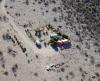
The airport at Guerrero Negro was cold, windy, and with a hint of fogginess to come. There were a couple of dark black military turboprops, the sleek Pilatus PC-21 of the Mexican Air Force. I was met with a larger contingent than normal of soldiers. I suppose that was to be expected, being a military base. They couldn’t have been nicer after they read my letter of introduction.<br /><br />The fueling guys were happy to see me. I asked them if they wanted to wait until the next day, Sunday, to fuel the airplane. “No es posible mañana.” It was their day off. (And it was pretty emphatic variation of a phrase I’d heard often: “Posible mañana.” From what I can figure out that’s a polite way of blowing off work.)<br /><br />The fuel guys were happy to give me a ride to the nearest hotel. It was a thirty minute drive. The nicest hotel room was $30 per night. I splurged and had the most expensive meal: $15 for wine and fish, including tip.<br />
| | Attachments:
Nicely Timed
| | |
|
Dan Nickens - Feb 12,2012
Viewers
| Reply
|
| |
One possible interpretation of the route to Guerrero Negro.
| | Attachments:
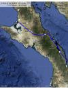
mlt2mgr
| | |
|
Don Maxwell - Feb 13,2012
Viewers
| Reply
|
| |
Jeez, Dan. You sure make it seem great fun to land at the Loreto aeropuerto! Was that experience typical of Mexican airports, or an unfortunate anomaly? <br /><br />We loved living in Mexico, but I've never tried flying there in my own airplane. <br /><br />(You've probably heard that the State Department is now warning Americans not to travel to the border states there. Sad.)
| | |
|
Joe Varner - Feb 13,2012
Viewers
| Reply
|
| |
Dan I guess someone has to ask. Is part of this another one of your <br />tales ?? Sounds like something you would see in a movie.
| | |
|
Dan Nickens - Feb 13,2012
Viewers
| Reply
|
| |
A movie, Joe? Really? Probably not. But what about a so-called 'reality' show for TV? Those things are really 'real', aren't they?
| | |
|
Joe Varner - Feb 13,2012
Viewers
| Reply
|
| |
Dan, It's way more fun to believe everyting is real, so I will just go with that. I have to commend you once again, you had me on the edge of my seat.
| | |
|
Frank A. Carr - Feb 13,2012
Viewers
| Reply
|
| |
Joe, According to legend, there might be a buried key that unlocks the secret of truth or not of a Nicken's story. But I'll never reveal. Only the author knows for sure.<!-- >'"><br><font color=red size=6>' or > missing in user HTML. Please fix the HTML.</font> -->
| | |
|
Joe Varner - Feb 13,2012
Viewers
| Reply
|
| |
The tell tale sign of a great author 
| | |
|
Frank A. Carr - Feb 14,2012
Viewers
| Reply
|
| |
Indeed and well put!
| | |
|
Dan Nickens - Feb 13,2012
Viewers
| Reply
|
| |
It is fun, Don, unless you are constrained by a schedule. The people were extraordinarily friendly and helpful. Most will fill out the forms for you. I don’t recall one unpleasant person. But the paperwork and bureaucracy is beyond absurd.<br /><br />There is no bureaucracy at uncontrolled fields. And you don’t need a flight plan, or an arrival report, or a weather briefing. There is no paperwork. Unfortunately there usually isn’t any fuel either.<br /><br />The State Department warning is a broad indictment. It is difficult, however, to generalize across entire regions. For example, despite the northern Baja being a border area, most of the killings and violence against American citizens takes place in Tijuana. Outside of Tijuana, the warning is to stay on the major roads and avoid travel after dark.<br /><br />The Bajamanians  I met were some of the nicest people on the planet. I’d go back again tomorrow.<br /> I met were some of the nicest people on the planet. I’d go back again tomorrow.<br />
| | |
|
Don Maxwell - Feb 13,2012
Viewers
| Reply
|
| |
Ah. Well, that sounds more like Mexico, then. Too bad about the lack of fuel at uncontrolled fields, though.
| | |
|
Dan Nickens - Feb 13,2012
Viewers
| Reply
|
| |
There are two good sources of published airport information for Mexico: the Bush Pilot International Guide to Mexican Airports and the Caribbean Tours Pilot's Guide to Mexico. The 2004 Bush Pilot Guide is the most current (with internet updates), but the Caribbean Tours version (2010) is in color! The information changes frequently, though, so the Bush Pilot guide is the best. My copies went north with the helicopter.<br /><br />The lack of fuel at smaller airports is a big problem for pilots needing 100LL. There are, however, other off airport alternatives for SeaRey pilots with the help of friendly locals.
| | Attachments:

BPI Airports of Mexico
| |
| Attachments:
Caribbean Sky Tours Flight Guide
| | |
|
Don Maxwell - Feb 13,2012
Viewers
| Reply
|
| |
Thanks, Dan! Good info!<br /><br />The AOPA Internet Flight Planner and Pilot My-Cast both show the larger, controlled Mexican airports, but I don't see any uncontrolled fields in them at all--except for where a US sectional includes portions of Mexico. (I haven't checked any other sources yet.)
| | |
|
Dan Nickens - Feb 13,2012
Viewers
| Reply
|
| |
At the risk of diminishing the versimilitude of a tall tale or two, Don, here is a WAC chart (CH-22) showing the area around Guerrero Negro complete with uncontrolled fields. As Dave said, many are now closed. For example, the airport at the top right, Bahia de Los Angeles North is listed by BPI as being 'closed due to lack of permit'.<br />
| | Attachments:
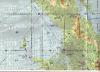
BajaWAC22
| | |
|
Don Maxwell - Feb 14,2012
Viewers
| Reply
|
| |
Dan, verisimilitude's best friend is the willing suspension of disbelief, which keeps Santa Claus and the Easter Bunny in business. <br /><br />Do WACs depict private airports now? I seem to recall that they do... or is it that they don't?
| | |
|
Dave Edward - Feb 13,2012
Viewers
| Reply
|
| |
Thanks again Dan for a fantastic travelogue. Sure is nice to <br />see aerial views of the places we have driven through. The <br />folks here in Baja are some of the most resourceful and <br />friendly people we have had the pleasure of associating with. <br />Your comments rethe bureaucracy are so true......and each <br />piece of paper generated costs a bit.<br />The crime is minimal....once you get a good distance south of <br />the border.<br />There is a Baja Bush Pilot guide around somewhere, but due <br />to the government crackdown on the drug trade, a lot of the <br />dirt strips have been bulldozed. A shame !<br />Even mo-gas is in short supply at times....especially away <br />from the ' tourist ' areas.
| | |
|
Wayne Nagy - Feb 16,2012
Viewers
| Reply
|
| |
It is also nice to see the aerial views by someone like me who has NEVER seen this area. The pictures are a real eye opener in a very positive way! Thanks, Dan.
| | |
|
|
|
|
|
|
|
|
|
|
|
| |
- About Searey.us -
- Contact Searey.us -
|
- Privacy Statement -
- Terms of service -
|
Copyright © 2024 Searey.us & Brevard Web Pro, Inc. -
Copyrights may also be reserved
by posters and used by license on this site. See Terms of Service for more information.
|
| |
- Please visit our NEW
Chapter Place Website at: chapterplace.com or
Free Chapter Management Website at: ourchapter.org. Good for all chapters, groups or families. |
| | | | | | | | | | | | | | | | | | | | | | | | | | | | | | | | | | | | | | | | | | | | | | | | |