|
|
 |
|
|
|
|
|
|
|
|
|
|
|
|
|

Click on photo to view the original size. |
| Viewers
|
|
|
|
|
|
|
|
|
|
|
Read what others had to say:
|
|
|
|
|
|
|
 |
Dan Nickens - Dec 05,2013
Viewers
| Reply
|
| |
Money can buy most anything, including a nice pond in the desert for water skiing. Conveniently located next to the Coachella Canal.
| | Attachments:

Desert Ski Pond
| | |
|
Charles Pickett - Dec 12,2013
Viewers
| Reply
|
| |
Looks like a seaplane base
| | |
|
Dan Nickens - Dec 05,2013
Viewers
| Reply
|
| |
A desert golf course? Of course. Did I mention what money could buy?
| | Attachments:
Desert Greens
| | |
|
Frank A. Carr - Dec 05,2013
Viewers
| Reply
|
| |
You'll probably mention this later in the sequence Dan, but it's not just money. <br />While the Coachella Valley has only has ~ 3' rain per year it has a huge Aquifer <br />for watering the Greens.
| | |
|
Dan Nickens - Dec 05,2013
Viewers
| Reply
|
| |
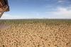
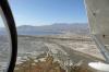
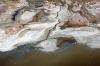
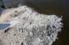
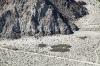
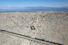
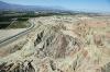
The reddish brown rocks are the surface expression of the San Andreas Fault in the Mecca Hills, Salton Trough. The Salton Trough or Sink is bounded to the west by the San Jacinto Fault, to the east by the San Andreas Fault.
| | Attachments:
Faulty Rocks
| | |
|
Dan Nickens - Dec 05,2013
Viewers
| Reply
|
| |
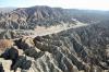
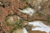
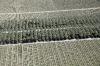
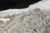
Old lake sediments have gotten all folded and mixed up thanks to two tectonic plates grinding past each other.
| | Attachments:

Sharp Rocks
| | |
|
Dan Nickens - Dec 05,2013
Viewers
| Reply
|
| |
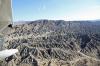
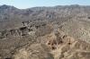
It’s tough out here, but nice out back in the Mecca Hill Wilderness Area.
| | Attachments:
Hard Country
| | |
|
Dan Nickens - Dec 05,2013
Viewers
| Reply
|
| |
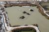
Not everyone has a green golf course but at least there are some nice ponds.
| | Attachments:

Mobile Community
| | |
|
Dan Nickens - Dec 05,2013
Viewers
| Reply
|
| |
Not all the ponds looked suitable for water skiing.
| | Attachments:
Not Ski Pond
| | |
|
Dan Nickens - Dec 05,2013
Viewers
| Reply
|
Dan Nickens - Dec 05,2013
Viewers
| Reply
|
| |
With apologies to John Masefield’s fine poem,<br /><br />I must go down to the seas again, for the call of the burning tide<br />Is a wild call and a clear call that may not be denied;<br />And all I ask is a windless day with the white clouds flying,<br />And the flung spray and the blown spume, and the sea-gulls crying.<br /><br />I must go down to the seas again, even if it's the salty ol’Salton Sea.<br />
| | Attachments:
Turn to Sea
| | |
|
Dan Nickens - Dec 05,2013
Viewers
| Reply
|
| |
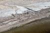
Before getting to the sea the old lake bed is full of potholes.
| | Attachments:

Patch of Potholes
| | |
|
Kenneth Leonard - Dec 05,2013
Viewers
| Reply
|
| |
What makes the potholes?
| | |
|
Dan Nickens - Dec 05,2013
Viewers
| Reply
|
| |
It's a mystery to me, Ken.
| | |
|
Dan Nickens - Dec 05,2013
Viewers
| Reply
|
| |
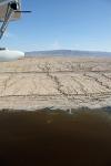
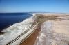
The flat Salton Sink has extensive marsh areas where once there was a much larger lake. Coastal stretching and faults dropped the Salton Sink to below sea level.
| | Attachments:
Salty Fingers
| | |
|
Dan Nickens - Dec 05,2013
Viewers
| Reply
|
| |
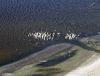
The Salton Sea is one of the major rest stops for birds on the Pacific Flyway.
| | Attachments:
Bird Bath
| | |
|
Frank A. Carr - Dec 05,2013
Viewers
| Reply
|
| |
I'm surprised the birds can stand the smell.
| | |
|
Dan Nickens - Dec 05,2013
Viewers
| Reply
|
| |
An interesting observation, Frank. While all birds have the necessary apparatus to smell in their naval passages, animal physiologists have reported that it is less well developed in certain species, including pelicans
| | |
|
Dan Nickens - Dec 05,2013
Viewers
| Reply
|
| |
Thirty percent of the remaining population of white pelicans <br />make the Salton Sea their home.
| | Attachments:

Bird Channel
| | |
|
Dan Nickens - Dec 05,2013
Viewers
| Reply
|
| |
Where are all the boats? They’ve gone and they won’t be <br />back. Why? Open the <br />canopy and smell that smell. To quote Skynard,<br />“Ooooh that smell <br />Can't you smell that smell <br />Ooooh that smell <br />The smell of death surrounds you”<br /><br />Quoting Col. Grumpy: “Looks good, smells bad.”<br />
| | Attachments:

Missing Boat
| | |
|
Dan Nickens - Dec 05,2013
Viewers
| Reply
|
| |
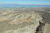
The Salton Sea has been a lake, a sea, a desert many times <br />over the last 3 million years. It’s now an endorheic basin with <br />no outlet for the streams that occasionally run into it.
| | Attachments:

Breaching Stream
| | |
|
Dan Nickens - Dec 05,2013
Viewers
| Reply
|
| |
Streams following lines down to lake.
| | Attachments:
Stream Lines
| | |
|
Dan Nickens - Dec 05,2013
Viewers
| Reply
|
| |
Bombay Beach, a film about the people in the town, won first <br />prize in the feature documentary section of the Tribeca Film <br />Festival in 2011.
| | Attachments:

Beatdown Beachtown
| | |
|
Dan Nickens - Dec 05,2013
Viewers
| Reply
|
| |
This is what Death Valley would look like with water.
| | Attachments:
Flat Shore
| | |
|
Dan Nickens - Dec 05,2013
Viewers
| Reply
|
| |
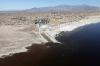
The most recent edition of the Salton Sea was created by <br />accident in 1905 (a breached canal diverting the Colorado <br />River). It is now feed by the “New River”: a canal from <br />Mexicali….full of the city’s wastewater, industrial dumping and <br />agricultural runoff. New River is one of the most contaminated <br />“rivers” on the continent. Not surprisingly, there have <br />been multiple episodes of fish and bird genocides.
| | Attachments:
Southern Plains
| | |
|
Dan Nickens - Dec 05,2013
Viewers
| Reply
|
| |
Native Americans mined high purity salt from the Salton <br />Sink before the Europeans arrived. In 1884 a San Francisco <br />businessman set up a company to extract the high <br />purity salt. He had a monopoly for 20 years before a <br />competitor determined that the U.S. Government owned the <br />land.<br /><br />The new company got a bill passed in Congress that <br />required claims be filed for mining. Both companies had <br />representatives in Washington to telegraph news of the <br />law’s signing. When the telegraphs arrived, it was a race to <br />get the claims staked. The old company set off down the <br />railroad tracks on pumphand cars . The new company left <br />town in a leisurely manner on a horse drawn wagon. The <br />new company had arranged to transmit the message at light <br />speed using mirrors. They got the best claims by being <br />fastest.<br /><br />Not that it mattered much. The Colorado River flooded the <br />sink in 1905 settling all claims by submerging the salt <br />mines.<br />
| | Attachments:

Salty Shore
| | |
|
Frank A. Carr - Dec 05,2013
Viewers
| Reply
|
| |
Fascinating country and geology; must be a delight for you Dan.
| | |
|
Dan Nickens - Dec 05,2013
Viewers
| Reply
|
| |
It is one of my all time favorite places, Frank.
| | |
|
Don Maxwell - Dec 05,2013
Viewers
| Reply
|
| |
And it's a hard, it's a hard, it's a hard, it's a hard,<br />It's a hard land's a-gonna fail. <br /><br />(Apologies to Bob Dylan.)
| | |
|
Dan Nickens - Dec 05,2013
Viewers
| Reply
|
| |
Sorry, Bob, but the land never fails. It evolves. This land may be hard, but it's sweet enough in its own way.
| | |
|
Dan Nickens - Dec 05,2013
Viewers
| Reply
|
| |
Evidence of water level fluctuation is easy to spot. The dropping water level leaves steep bank to mark the spot.
| | Attachments:
Sharp Scarp
| | |
|
Dan Nickens - Dec 05,2013
Viewers
| Reply
|
| |
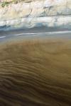
In an attempt to stop 10 to 20 million gallons per day of raw sewage from entering the New River and ultimately the Salton Sea, the U.S. and Mexico are built a wastewater treatment plant in Mexicali. Problem solved? Not exactly. Water from the plant no longer goes to the river and is used for agricultural purposes. The reduced flow in the river concentrates contaminates from other sources in its greatly reduced flow. Basically, as less water enters the Salton Sea and evaporation continues to concentrate what’s left, water quality get increasingly feculent. It’s just like the Fugs sang,<br />“River of (feces),<br />River of (feces),<br />Flow on, flow on, river of (feces),<br />Right from my toes,<br />On up to my nose,<br />Flow on, flow on, river of (feces).”<br />
| | Attachments:
Brown Waves
| | |
|
Dan Nickens - Dec 05,2013
Viewers
| Reply
|
| |
As the Fugs also sang, “A wiiiiiiiiiiiiide, big brown river, yea, bringing health, wealth, and prosperity to every man, women, and child.”<br /><br />Well, maybe not so much.<br />
| | Attachments:

Waves of Brown
| | |
|
Dan Nickens - Dec 05,2013
Viewers
| Reply
|
Dan Nickens - Dec 05,2013
Viewers
| Reply
|
| |
Wet fields of brown are matched sets for the lake water.
| | Attachments:

Brown Fields
| | |
|
Dan Nickens - Dec 05,2013
Viewers
| Reply
|
| |
It might be winter but not all that is covered in white is snow.
| | Attachments:
Not Snow
| | |
|
Dan Nickens - Dec 05,2013
Viewers
| Reply
|
Dan Nickens - Dec 05,2013
Viewers
| Reply
|
| |
An old work barge melting in the salt.
| | Attachments:
Saltwrecked
| | |
|
Dan Nickens - Dec 05,2013
Viewers
| Reply
|
| |
In the late 19th century it was suggested that the Colorado River should be diverted to recreate a lake in the Salton Sink. Joseph Widney, a President of USC, thought that would generate enough moisture to eliminate the southern California deserts and create a new “Eden.” If it weren’t for the Colorado River delta now, the Salton Sink would be part of the Sea of Cortez.
| | Attachments:

Blue Horizon
| | |
|
Dan Nickens - Dec 05,2013
Viewers
| Reply
|
| |
Premium water front high rise condos only accessible by air.
| | Attachments:

Nice Nests
| | |
|
Dan Nickens - Dec 05,2013
Viewers
| Reply
|
| |
Birds lined streams and shore. The waterline may not know where it should be, but the birds know where it has been.
| | Attachments:

Stream liners
| | |
|
Dan Nickens - Dec 05,2013
Viewers
| Reply
|
| |
White sand, green water, brown water.
| | Attachments:

Water Colors
| | |
|
Dan Nickens - Dec 05,2013
Viewers
| Reply
|
| |
A green lagoon separates the brown lake from the white land.
| | Attachments:

Salt Lagoon
| | |
|
Dan Nickens - Dec 05,2013
Viewers
| Reply
|
| |
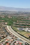
Backed up by Palm Springs the ground is a lot less brown.
| | Attachments:

Greenways
| | |
|
Dan Nickens - Dec 05,2013
Viewers
| Reply
|
| |
A golf community snuggled up to hills surrounds itself in green against the towering brown hills.
| | Attachments:

Oasis
| | |
|
Dan Nickens - Dec 05,2013
Viewers
| Reply
|
| |
Houses circled in defensive mode…Indian attack? Or brown attack? Imported water helps keep the brown at bay.
| | Attachments:

Circling the Wagons
| | |
|
Dan Nickens - Dec 05,2013
Viewers
| Reply
|
| |
Two different approaches to water management: concrete ditch or green fairway.
| | Attachments:
Spillway
| | |
|
Dan Nickens - Dec 05,2013
Viewers
| Reply
|
| |
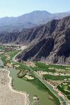
All available valley floor is used for golf course, housing, and the all important aqueduct.
| | Attachments:
On Edge
| | |
|
Dan Nickens - Dec 05,2013
Viewers
| Reply
|
| |
Not everyone fights against the surrounding brown. This golf course merges green with desert brown.
| | Attachments:

Blended Environments
| | |
|
Don Maxwell - Dec 08,2013
Viewers
| Reply
|
| |
An inverse golf course with greentraps.<br /><br />Those condos are really peculiar: four two-car garages out at the road and then... what? Are the units side by side, or stacked? Who lives where? Who gets the two fake chimneys?
| | |
|
Dan Nickens - Dec 05,2013
Viewers
| Reply
|
| |
It wasn’t that long ago that there was a lake in the place of the sea: Lake Cahuilla. It was present from 20,000 years BP to 3000 years BP. Evidence of its old shoreline can be seen up in the hills surrounding Palm Springs.<br /><br />Lake Cahuilla formed when the Colorado shifted its course within the delta. Under recent climatic conditions, it would have taken several decades to fill up. When the river shifted again, the isolated sink would have taken about 50 years to dry out again.<br />
| | Attachments:
Bathtub Rings
| | |
|
Dan Nickens - Dec 08,2013
Viewers
| Reply
|
| |
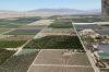
Crops line up where the aqueduct goes.
| | Attachments:
Crop Strips
| | |
|
Don Maxwell - Dec 08,2013
Viewers
| Reply
|
| |
Even the green looks brown.
| | |
|
Dan Nickens - Dec 08,2013
Viewers
| Reply
|
| |
Brown streams down from the hills.
| | Attachments:
Dry Washing
| | |
|
Dan Nickens - Dec 08,2013
Viewers
| Reply
|
| |
There are so many different paths water can take (when there is water).
| | Attachments:

Braided Wash
| | |
|
Dan Nickens - Dec 08,2013
Viewers
| Reply
|
| |
It all flows downhill….below sea level to the Salton Sea.
| | Attachments:
Wash to Sea
| | |
|
Dan Nickens - Dec 08,2013
Viewers
| Reply
|
| |
Plenty of lots still remaining to investors looking for long term opportunity. Really long term.
| | Attachments:
Room to Grow
| | |
|
Dan Nickens - Dec 08,2013
Viewers
| Reply
|
| |
Someone was dreaming of a city by the sea.
| | Attachments:

Vacancies
| | |
|
Dan Nickens - Dec 08,2013
Viewers
| Reply
|
| |
An old park rapidly falling to ruin. For a video on the post-Apocalyptic Salton Sea, see the link.
| | Attachments:

The Accidental Sea
| |
| Attachments:
Past Resort
| | |
|
Don Maxwell - Dec 08,2013
Viewers
| Reply
|
| |
One advantage of flying is that you get to go up high enough to see that everywhere is connected to everywhere else--a kind of optical synergy. The view in the video limits your perspective so that entropy seems to become Everything.
| | |
|
Dan Nickens - Dec 08,2013
Viewers
| Reply
|
| |
That's so well spotted, Don. Thank you.
| | |
|
Frank A. Carr - Dec 08,2013
Viewers
| Reply
|
| |
The Salton Sea must be right up there as one of the strangest places in modern USA.
| | |
|
Dan Nickens - Dec 08,2013
Viewers
| Reply
|
| |
It’s tough to keep a boat ramp in the water when the sea is shrinking.
| | Attachments:
Sinking Sealevel
| | |
|
Dan Nickens - Dec 08,2013
Viewers
| Reply
|
| |
The sea doesn’t seem so brown when looking towards the blue horizon.
| | Attachments:

More Blue
| | |
|
Dan Nickens - Dec 08,2013
Viewers
| Reply
|
Frank A. Carr - Dec 08,2013
Viewers
| Reply
|
| |
Or in SC where the Corpse of Engineers successfully prove <br />their mismanagement of lake <br />water levels almost every year:
| | Attachments:

Lake Hartwell
| | |
|
Dan Nickens - Dec 08,2013
Viewers
| Reply
|
| |
Not everyone is content to share the salty airspace.
| | Attachments:

Mass Departure
| | |
|
Dan Nickens - Dec 08,2013
Viewers
| Reply
|
| |
White flight….”There goes the neighborhood.”
| | Attachments:

Pelican Launch
| | |
|
Dan Nickens - Dec 08,2013
Viewers
| Reply
|
| |
This flight has great formation discipline.
| | Attachments:

Break Left
| | |
|
Dan Nickens - Dec 08,2013
Viewers
| Reply
|
| |
Crops down in the valley are nicely organized.
| | Attachments:
Valley View
| | |
|
Dan Nickens - Dec 08,2013
Viewers
| Reply
|
| |
Jagged rocks and flat valley intersect with the sharp edges of the canal.
| | Attachments:
Sharp Edges
| | |
|
Dan Nickens - Dec 08,2013
Viewers
| Reply
|
| |
Back in town there’s a fine fair.
| | Attachments:

Fair Day
| | |
|
Dan Nickens - Dec 08,2013
Viewers
| Reply
|
| |
A protected place for rocks and shrubs?
| | Attachments:

Rock Garden
| | |
|
Russ Garner - Dec 08,2013
Viewers
| Reply
|
| |
So what's the mission Dan or is there one.
| | |
|
Dan Nickens - Dec 08,2013
Viewers
| Reply
|
| |
The primary mission, Russ, is to keep the yacht's SeaRey in position for immediate action at the owner's beck and call. The secondary mission, the one that demands most time of my time, is to keep it safe from the ravages of disuse.
| | |
|
Russ Garner - Dec 08,2013
Viewers
| Reply
|
| |
Very good Dan a true working venture with some scenic destinations. There are some great places in Southern California to fly to for the day or and over night stay.
| | |
| | | | | | | | | | | | | | | | | | | | | | | | | | | | | | | | | | | | | | | | | | | | | | | | | | | | | | | | | | | | | | | | | | | | | | | | | | | | | | |