 |
|
|
|
|
|
|
Posted By:
Hal Brown
Date Posted:
Jun 30, 2014
Description:
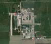
Another view of the strange crop on this farm. As I recall from driving near it earlier in the century, there's a sign saying something like 'KEEP THE HELL OUT.' Well, maybe it said, 'Property of the United States of America,' or something of the sort. Navy, I think. I started to post the coordinates, but then decided that there's probably some reason this farm isn't marked on the maps.
('Strange Fruit' is a song not heard much these days, but worth listening to if you can find it. However, it has no direct connection to this farm--I trust.)
Date Taken:
Jun 30, 2014
Place Taken:
Pamunkey River, Central VA
Owner:
Don Maxwell
File Name:
AntennaFarm_2296.jpg - Photo HTML
Full size - <img src="/show.php?splash=SZDQJ0000h">
Medium - <img src="/show.php?splash=SZDQJ0000m">
Thumbnail - <img src="/show.php?splash=SZDQJ0000s">
Category:
23, Max Pix
|
|
|
|
|

Click on photo to view the original size. |
| Viewers
|
|
|
|
|
|
|
|
|
|
|
Read what others had to say:
|
|
|
|
|
|
|
 |
Don Maxwell - Jul 02,2014
Viewers
| Reply
|
| |
Well, what the heck. Here are the coordinates: 37.565082, -77.024146 Maybe someone can recognize it.<br /><br />In GoogleMaps it's: https://<a href="http://www.google.com/maps/place/37%C2%B033'54.3%22N+77%C2%B001'26.9%22W/?37.5659691">www.google.com/maps/place/37%C2%B033'54.3%22N+77%C2%B001%2<br>726.9%22W/@37.5659691</a>
| | |
|
Frank A. Carr - Jul 03,2014
Viewers
| Reply
|
| |
Are you friends with Edward Snowden?
| | |
|
Frank A. Carr - Jul 03,2014
Viewers
| Reply
|
| |
For your next overflight, deploy extra chaff.
| | |
|
Don Maxwell - Jul 03,2014
Viewers
| Reply
|
| |
I'm not worried about that site, Frank. It's actually not hidden at all, and as you see it's clearly visible in the satellite photos. (On the other hand, Google blurs license plate numbers and lots of faces.)<P>But I do worry a bit when flying over the Blackwater campus in northeastern NC. The coordinates are 36.457239, -76.206830, and it's visible on the satellite photos, although not on the sectional charts.<P><img src="inline/20003-Screen_Shot_2014_07_03_at_10.53.45_AM.jpg" alt="Screen Shot 2014-07-03 at 10.53.45 AM"><P>Those are someone else's notations on the GoogleMaps image, by the way. The "Academi" note is particularly interesting. You can search GoogleMaps for "academi" and find an airport not far from Blackwater. Airnav.com says it's NC61: <a href="http://airnav.com/airport/NC61">http://airnav.com/airport/NC61</a><P><a href="https://www.google.com/maps/?36.4563499,-76.2091369,1180m/data=!3m1!1e3">Blackwater</a><!-- >'"><br><font color=red size=6>' or > missing in user HTML. Please fix the HTML.</font> -->
| | Attachments:
Screen Shot 2014 07 03 at 10.53.45 AM
| | |
|
Don Maxwell - Jul 03,2014
Viewers
| Reply
|
| |
The day this satellite photo was taken, Blackwater had at least two fixed wing airplanes on the ramps and at least 15 helicopters, one with the mainrotor turning.
| | |
|
|
|
|
|
|
|
|
|
|