 |
|
Photos
View |
|
All Photos |
Add Photos |
Emoticons |
Album View |
Mark Unread
|
|
|
|
|
|
|
|
|
|
|
|
Posted By:
Don Maxwell
Date Posted:
Oct 30, 2019
Description:
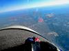
A few days ago I flew across the Chesapeake Bay to KCGE, Cambridge, MD. Usually I fly that route at around 1,000 feet or less and sometimes down at 10 feet over the water. But this time there was a 15 knot headwind down there. Beginning at about 7,000 feet, however, it switched to a tail wind, and it seemed prudent to ride in it.
So I went up to cruise at 11,500 feet--but "cruise" isn't really the right word for it. I was loafing along at about 80 mph indicated.
(The number depended on which indicator I happened to be looking at. Both the analog picture and the digital display are calibrated in mph; but the analog one also has a knot scale around the outside of it.)
The smaller digital gizmo also indicated a True airspeed (TAS) of 100 mph (largest red oval) and the other gizmo, a GPS, said I was doing 103 knots over the ground (or water). 103 knots is 118.5 mph. So I had a tailwind component of about 30 knots, or so. I could afford to loaf.
The OAT there was 1 degree C, roughly 34 F. And the density altitude was around 12,000 feet.
No supplemental oxygen, but evidently none was needed.
Date Taken:
2019-10-24
Place Taken:
Nearly over the Chesapeake Bay
Owner:
Don Maxwell
File Name:
- Photo HTML
Full size - <img src="/show.php?splash=7YBh8JJbCh">
Medium - <img src="/show.php?splash=7YBh8JJbCm">
Thumbnail - <img src="/show.php?splash=7YBh8JJbCs">
Category:
Max Pix
|
|
|
|
|

Click on photo to view the original size. |
| Viewers
|
|
|
|
|
|
|
|
|
|
|
Read what others had to say:
|
|
|
|
|
|
|
 |
Don Maxwell - Oct 29,2019
Viewers
| Reply
|
| |
Here's the view ahead there. (To see the image full size, click on it and then click again.)
Scylla and Charybdis are the two hazards that Odysseus has to steer his ship between in The Odyssey, to avoid catastrophe. In my low-altitude aerial voyages across The Bay I have to steer between R-4007 and Washington DC SFRA. They're actually about 10 miles apart, but when navigating by pilotage I steer between the white tanks (Scylla) and the power plant (Charybdis), which often makes a whirlpool in the Bay with its cooling water. I was more than a mile above R-4007 on this flight, but the threat of Charybdis is always there. On the return trip, down low, I stayed in between them.
Once when heading southwest with Carol aboard, the GPS signal went away when we were in the middle of the Bay and didn't come back until we were well past PAX River. Later I phoned the NAS, but they denied jamming the signal.
| | Attachments:
IMG 7165-NearTheChesapeakeBay
| | |
|
|
|
|
|
|
|
|