|
|
 |
|
|
|
|
|
|
|
|
|
|
|
|
|

Click on photo to view the original size. |
| Viewers
|
|
|
|
|
|
|
|
|
|
|
Read what others had to say:
|
|
|
|
|
|
|
 |
Nickens, Dan - Dec 21,2018
Viewers
| Reply
|
| |
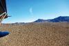
Getting back to Phoenix was an easy day's flight plan. There was no point in going back the way I'd come. I traced out a different path on chart, turning east instead of south down the river.
Boulder City, NV
| | Attachments:
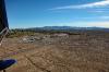
6-2 Leaving Las Vegas 0259
| | |
|
Nickens, Dan - Dec 21,2018
Viewers
| Reply
|
| |
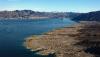
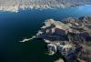
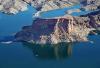
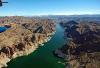
Sure I'd seen Lake Mead the day before, and on other occasions, but I never get tired of the spectacular water lying in a desert land.
North side of Fortification Hill, Arizona
| | Attachments:
6-3a Re-trace 0262
| | |
|
Nickens, Dan - Dec 21,2018
Viewers
| Reply
|
| |
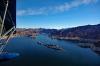
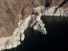
Following the channel out through Boulder Canyon.
Beacon Rock, Clark County, Lake Mead, NV
| | Attachments:
6-3b Channel Marker 0263
| | |
|
Nickens, Dan - Dec 21,2018
Viewers
| Reply
|
| |
Stop and explore? Not this day. I was looking for new places, and had all day to find them.
Auxiliary Point, Lake Mead, NV
| | Attachments:
6-4 Little Italy 0271
| | |
|
Nickens, Dan - Dec 21,2018
Viewers
| Reply
|
Nickens, Dan - Dec 21,2018
Viewers
| Reply
|
| |
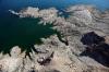
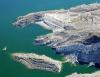
It's been a long time since the water was high enough to bleach up high on the exposed cliffs. The white is starting to get smudged up.
Boulder Canyon, NV
| | Attachments:
6-6 Smudging 0275
| | |
|
Carr, Frank - Dec 29,2018
Viewers
| Reply
|
| |
Dan, by a "long time" are you talking millions or decades?
| | |
|
Nickens, Dan - Jan 04,2019
Viewers
| Reply
|
| |
Decades.... repeated times however many times the question appears! 🤔
| | |
|
Carr, Frank - Dec 29,2018
Viewers
| Reply
|
| |
Dan, by a "long time" are you talking millions or decades?
| | |
|
Carr, Frank - Dec 29,2018
Viewers
| Reply
|
| |
Dan, by a "long time" are you talking millions or decades?
| | |
|
Carr, Frank - Dec 29,2018
Viewers
| Reply
|
| |
Dan, by a "long time" are you talking millions or decades?
| | |
|
Carr, Frank - Dec 29,2018
Viewers
| Reply
|
| |
Dan, by a "long time" are you talking millions or decades?
| | |
|
Carr, Frank - Dec 29,2018
Viewers
| Reply
|
| |
Dan, by a "long time" are you talking millions or decades?
| | |
|
Carr, Frank - Dec 29,2018
Viewers
| Reply
|
| |
Dan, by a "long time" are you talking millions or decades?
| | |
|
Carr, Frank - Dec 29,2018
Viewers
| Reply
|
| |
Dan, by a "long time" are you talking millions or decades?
| | |
|
Wayne Nagy - Dec 29,2018
Viewers
| Reply
|
| |
Wow, Frank! You REALLY want an answer to this.... :-)
| | |
|
Carr, Frank - Dec 30,2018
Viewers
| Reply
|
| |
How do I even do that????
| | |
|
Don Maxwell - Dec 30,2018
Viewers
| Reply
|
| |
Frank, it can happen if you post something and immediately hit the Back button and then do anything except Cancel or Back. But I think you've just set an all-time world record for it.
| | |
|
Carr, Frank - Dec 31,2018
Viewers
| Reply
|
| |
Further more, I've been "DELETING" for several minutes with no progress.
| | |
|
Nickens, Dan - Dec 21,2018
Viewers
| Reply
|
| |
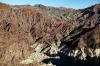
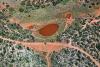
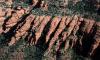
There's red, then there's bright red. There was a breakout of bright red in just enough places to keep it special.
Boulder Canyon, NV
| | Attachments:
6-7 Red Patches 0277
| | |
|
Nickens, Dan - Dec 21,2018
Viewers
| Reply
|
| |
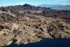
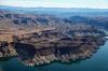
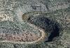
Beyond the hard walls of the canyon some softer hills provided more room to wander.
Black Mountains, Virgin Basin, Lake Mead, NV
| | Attachments:
6-8 Softer Side 0285
| | |
|
Nickens, Dan - Dec 21,2018
Viewers
| Reply
|
| |
Turn north? Not today. It would clearly be out of any reasonable looking path back to Phoenix, and there were plenty of other attractive options to investigate that wouldn't unduly disturb the airplane's rightful owner.
Overton Arm, Virgin Basin, Lake Mead, NV
| | Attachments:
6-9 North Option 0291
| | |
|
Nickens, Dan - Jan 24,2019
Viewers
| Reply
|
| |
The northern arm is where a B-29 rests. There is a National Park Service video showing the airplane in its final resting place.
| | Attachments:

Lake Mead B-29
| | |
|
Philip Mendelson - Jan 27,2019
Viewers
| Reply
|
| |
Awesome post!
| | |
|
Nickens, Dan - Dec 21,2018
Viewers
| Reply
|
| |
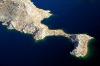
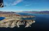
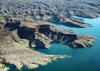
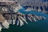
The shoreline of Lake Mead has some pretty intricate corners that would be worthy of exploration by SeaRey (but there were newer places to see just beyond the horizon).
The Jawbone (top), Lake Mead, NV
| | Attachments:
6-10 Ragged Shores 0297
| | |
|
Nickens, Dan - Dec 21,2018
Viewers
| Reply
|
| |
Most of the former lake bottom is still pretty rough, but there is an occasional soft patch of sand.
Temple Basin, Lake Mead, AZ
| | Attachments:
6-11 Formerly Lake Bottom 0299
| | |
|
Nickens, Dan - Dec 21,2018
Viewers
| Reply
|
| |
The most impressive thing about the lake is its stark wetness in contrast with the surrounding desert.
White Hills, Inshore Lake Mead, AZ
| | Attachments:
6-13 Dry Side 0300
| | |
|
Nickens, Dan - Dec 21,2018
Viewers
| Reply
|
| |
There were a few flat spots in surrounding hills; mesas that resisted erosion. Like a rocky aircraft carrier, it could be a fine place for a land plane in distress. For a seaplane, it wasn't much of a temptation.
Delmar Butte, Lake Mead, NV
| | Attachments:
6-14 Flat Spot 0305
| | |
|
Nickens, Dan - Dec 21,2018
Viewers
| Reply
|
| |
Instead of looking longingly at something flat, it was the steep sandy beach that got my attention. It looked absolutely fetching! How could I pass it up? Well, the day was just starting and I'd spent a fair amount of time on the lake. But, really, it was the prospect of places I hadn't been before that let me pass on with no sand on my feet.
Near Plane Crash Island, Lake Mead, AZ
| | Attachments:
6-14 Steep Beaches 0306
| | |
|
Don Maxwell - Dec 21,2018
Viewers
| Reply
|
| |
That beach does look inviting, Dan. But Plane Crash Island! Let's go there!
| | |
|
Nickens, Dan - Dec 21,2018
Viewers
| Reply
|
| |
Let's NOT!
| | |
|
Nickens, Dan - Dec 21,2018
Viewers
| Reply
|
| |
This temple might have been a stronger attraction except worshippers were already gathered below its majesty.
The Temple, Lake Mead, AZ
| | Attachments:
6-15 Big Butte 0308
| | |
|
Nickens, Dan - Dec 21,2018
Viewers
| Reply
|
| |
There was no interest in exploring this giant flat spot for potential landing opportunities. It was so expansive the challenge would be just be too minimal.
(Excuses, just lame excuses!)
Temple Mesa, Lake Mead, AZ
| | Attachments:
6-16 Temple Mesa 0309
| | |
|
Nickens, Dan - Dec 21,2018
Viewers
| Reply
|
| |
Burro Bay would have been unmissable except for the obvious lack of burros. Yes, the critters are difficult to spot, and blend in well with the rocks. Still, why risk disappointment on such a fine day!
Burro Bay, Lake Mead, AZ
| | Attachments:
6-17 Steep Shore 0310
| | |
|
Nickens, Dan - Dec 21,2018
Viewers
| Reply
|
| |
There was one last opportunity for an adrenaline rush on Lake Mead: Virgin Canyon. But, no! I had convinced myself there was something new and different and delightful waiting out there somewhere ahead. Instead I turned south up a dry wash.
Virgin Canyon, Lake Mead, NV & AZ
| | Attachments:
6-18 Manmade Canal 0314
| | |
|
Nickens, Dan - Dec 21,2018
Viewers
| Reply
|
| |
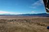
It was a big wash. Looking back, the view showed me abandoning one of the world's best SeaRey playgrounds, all for the prospect of something new and different. What was wrong with tried and true blue? Nothing. I was just getting greedy.
Hualapai Wash, AZ
| | Attachments:
6-19 Wash to Lake 0317
| | |
|
Nickens, Dan - Dec 21,2018
Viewers
| Reply
|
| |
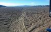
The immediate cost of greedily looking for new water was an intense dryness stretching to the far horizon.
South into Hualapai Wash, AZ
| | Attachments:
6-20 Trending Dry 0318
| | |
|
Nickens, Dan - Dec 21,2018
Viewers
| Reply
|
| |
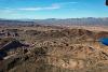
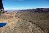
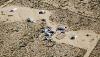
From the rare abode out on the vast wash it was clear that life was hard. The chart showed lots of mines nearby. Perhaps the residents had traded good opportunities elsewhere for the allure of hidden gems? A lesson for the greedy?
Near the old Bluebird Mine, Hualapai Wash, AZ
| | Attachments:
6-21 Hard Scrabble 0321
| | |
|
Nickens, Dan - Dec 21,2018
Viewers
| Reply
|
| |
There was a boat sitting forlornly outside the little shack. Abandoned? Left to rot? Maybe it was there in case of flash flooding. Whatever. It would have taken the owner an hour to get to the aquatic Elysium of Lake Mead. For me, it was just minutes behind.
Hualapai Wash, AZ
| | Attachments:

6-22 Dry Camp 0323
| | |
|
Nickens, Dan - Dec 21,2018
Viewers
| Reply
|
| |
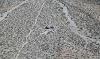
Someone had hopes of finding their real estate fortune out on the dry plain. Maybe next year.
Near Burnt Mill, AZ
| | Attachments:
6-24 Future Subdivision 0326
| | |
|
Nickens, Dan - Dec 21,2018
Viewers
| Reply
|
| |
Proof that relic examples of some folks' failures to find what they were looking for will not discourage others from seeking their fortunes in the same place?
Near Burnt Mill, AZ
| | Attachments:
6-25 RV Park 0327
| | |
|
Nickens, Dan - Dec 21,2018
Viewers
| Reply
|
| |
Did I really trade a day over a brilliant blue lake for a splash-less flight over the waterless wasteland of a bone dry lake?
Red Lake, AZ
| | Attachments:
6-26 Red Lake 0331
| | |
|
Nickens, Dan - Dec 21,2018
Viewers
| Reply
|
Nickens, Dan - Dec 21,2018
Viewers
| Reply
|
| |
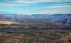
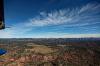
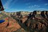
After climbing out of the wash with its big dry lake, the edges of the Grand Canyon were visible on the horizon. Too bad, so sad, that canyon and its river are off-limits to wandering SeaReys.
Meriwhitica Canyon, North of Truxton, AZ
| | Attachments:
6-28 South Rim 0357
| | |
|
Dave Edward - Dec 23,2018
Viewers
| Reply
|
| |
When we did the heli tour of the canyon a year ago, the pilot told me that whole Grand Canyon area was second only to Washington
and the White House area etc. for regulations regarding extra curricular flight. I twigged to something when we hovered for a minute
or so just off the rim. Asked him if we had a " slot time ". We did.
| | |
|
Nickens, Dan - Dec 21,2018
Viewers
| Reply
|
| |
A cinder cone stuck up like a sore thumb out of the plains. It looked out of place and tiny compared to the massive volcanoes further north.
Plain Tank Flat, Hualapai Indian Reservation
| | Attachments:
6-29 Lone Cone 0368
| | |
|
Nickens, Dan - Dec 21,2018
Viewers
| Reply
|
| |
The lone corral was a crossroads for cows in more ways than one.
Big Chino Wash NW of Picacho Butte, AZ
| | Attachments:
6-30 Lone Corral 0388
| | |
|
Nickens, Dan - Dec 21,2018
Viewers
| Reply
|
| |
There wasn't much evidence of fall out on the big butte, but it was there in the stream beds.
Big Chino Wash near Picacho Butte, Az
| | Attachments:
6-31 Wash Colors 0391
| | |
|
Nickens, Dan - Dec 21,2018
Viewers
| Reply
|
| |
One of the big volcanoes of the San Francisco Peaks could be seen on the horizon: Humphreys Peak. General Humphreys was a Union officer who went on to ignominy as Chief of the Corpse of Engineers. Figures they'd name a blown out volcano after him.
Humphreys Peak, AZ
| | Attachments:
6-32 Distant Snow 0395
| | |
|
Nickens, Dan - Dec 21,2018
Viewers
| Reply
|
| |
Red dirt and red water. Figures.
Big Chino Wash near Paulden, AZ
| | Attachments:
6-33 Red Spots 0397
| | |
|
Don Maxwell - Dec 21,2018
Viewers
| Reply
|
| |
Wow! That looks like Carolina red clay or West African laterite--but I've never seen those soils coloring water so red.
| | |
|
Nickens, Dan - Dec 21,2018
Viewers
| Reply
|
| |
It's probably the distinct process of cows stirring up hematite rich dust?
| | |
|
Nickens, Dan - Dec 21,2018
Viewers
| Reply
|
| |
The Hell Canyon bridge was part of US 89, a road that was abandoned after Interstate highways came through.
The nearby mine produces Arizona Flagstone, a red sandstone used in construction.
Near Drake, AZ
| | Attachments:
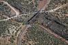
6-34 Busy Crossings 0402
| | |
|
Nickens, Dan - Dec 21,2018
Viewers
| Reply
|
| |
A pretty serious s-turn provided a good challenge to following the water's course from overhead (but with no risk of running into the rock wall if I didn't navigate the turn).
Near Perkinsville, AZ
| | Attachments:
6-35 Caution in Turns 0413
| | |
|
Nickens, Dan - Dec 21,2018
Viewers
| Reply
|
Nickens, Dan - Dec 21,2018
Viewers
| Reply
|
| |
The little puddle offered pretty meager prospects for SeaReying, particularly after leaving the vast water of Lake Mead behind. Sigh.
Verde River near Perkinsville, AZ
| | Attachments:
6-37 Puddle in River 0421
| | |
|
Nickens, Dan - Dec 21,2018
Viewers
| Reply
|
| |
It's foolish to complain about lack of water in a desert, particularly when the skies are blue, the winds are fair, and the scenery is spectacular.
Near Perkinsville, AZ
| | Attachments:
6-38 Fair Skies 0422
| | |
|
Nickens, Dan - Dec 21,2018
Viewers
| Reply
|
| |
It would be a heck of a scenic ride on the railway running through the Verde River valley. That'd be a poor second to flying over it in a SeaRey though.
Near Perkinsville, AZ
| | Attachments:
6-39 Scenic Rails 0431
| | |
|
Nickens, Dan - Dec 21,2018
Viewers
| Reply
|
| |
The edges of the river valley were definitively lined by rocky ledges.
Packard Mesa, Sycamore Canyon Wilderness Area, AZ
| | Attachments:
6-40 Rock Lines 0439
| | |
|
Nickens, Dan - Dec 21,2018
Viewers
| Reply
|
Nickens, Dan - Dec 21,2018
Viewers
| Reply
|
Nickens, Dan - Dec 21,2018
Viewers
| Reply
|
| |
The radical turn was a bit to sharp for leisurely SeaRey IFR ("I Follow Rivers" . .
Sycamore Canyon Wilderness Area, AZ
| | Attachments:
6-43 Sharp Turn 0469
| | |
|
Nickens, Dan - Dec 21,2018
Viewers
| Reply
|
| |
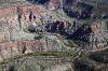
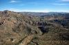
The red rock columns of Schnebly Hill Sandstone were formed when seas came and went through the area, leaving layers of limestone mixed with quartz beach sand, all colored by iron oxide (hematite). The cliffs are so steep because the softer sediments are overlain by a layer of basalt and hard limestone, exposed around the edges of Colorado Plateau (the Mogollon Rim). The southern edge of the plateau runs through central Arizona and marks the transition to the Basin and Range province to the south.
Sycamore Canyon Wilderness Area, AZ
| | Attachments:
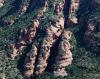
6-44 Canyon Columns 0485
| | |
|
Nickens, Dan - Dec 21,2018
Viewers
| Reply
|
| |
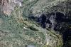
The canyon floors would be spectacular enough, but the yellows and rusty reds of the vegetation added nice accents to all the rocky splendor.
Sycamore Canyon Wilderness Area, AZ
| | Attachments:
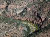
6-45 Canyon Floor 0488
| | |
|
Nickens, Dan - Dec 21,2018
Viewers
| Reply
|
| |
Classic "Layer Cake" geology.
Coconino National Forest, near Casner Mountain, AZ
| | Attachments:
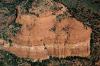
6-46 Band of Rocks 0507
| | |
|
Nickens, Dan - Dec 21,2018
Viewers
| Reply
|
| |
Big red rock fins sticking out from the plateau like the tail end of a 1959 Cadillac Eldorado.
Red Rock Secret Mountain Wilderness, AZ
| | Attachments:
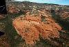
6-47 Rock Fins 0520
| | |
|
Nickens, Dan - Dec 21,2018
Viewers
| Reply
|
| |
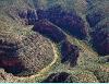
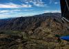
Lots of parallel joints and fractures make for thinly sliced rocks.
Red Rock Secret Mountain Wilderness, AZ
| | Attachments:
6-48 Finely Sliced 0529
| | |
|
Nickens, Dan - Dec 21,2018
Viewers
| Reply
|
| |
Some fractures were much bigger and more prominent.
Hart Well Canyon, AZ
| | Attachments:
6-49 Big Slice 0537
| | |
|
Nickens, Dan - Dec 21,2018
Viewers
| Reply
|
Nickens, Dan - Dec 21,2018
Viewers
| Reply
|
| |
After cruising through the rock wilderness I figured that I would land in the fabled town of Sedona for lunch and gas. Tuning in to the radio frequency, however, I found it was very busy. There was an undercurrent of stress in the transmissions. Who needs that? I turned to my alternate, the Cottonwood Airport (P52). Arriving there the clock showed 3.1 flight hours from Boulder City, all without a single splash. Though the scenery had been spectacular I was beginning to regret not spending more of my time playing at Lake Mead.
P52 Cottonwood Airport, AZ
| | Attachments:
6-51 Fuel Break 0551
| | |
|
Ken Leonard - Dec 21,2018
Viewers
| Reply
|
| |
Dan - my son just settled in Cottonwood! My wife and I visited him in Sedona, where he works, a couple of weeks ago and did some
hiking in those lovely hills. It's tough , and wonderful, country!
| | |
|
Nickens, Dan - Dec 21,2018
Viewers
| Reply
|
| |
It looks amazing from the air, Ken. And you have a great reaon to visit. There is so much to explore, and with local support, too!
Very cool.
| | |
|
Nickens, Dan - Dec 22,2018
Viewers
| Reply
|
| |
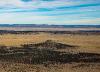
The Verde River was a bit bigger and wetter after Cottonwood, but there still wasn't enough water to play in.
Verde River Near Cornville, AZ
| | Attachments:
6-52 Tri-Colors 0558
| | |
|
Nickens, Dan - Dec 22,2018
Viewers
| Reply
|
| |
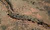
It was still fun to follow the water through all the dry rock.
Cedar Bench Wilderness Area, AZ
| | Attachments:
6-53 Winding Through 0585
| | |
|
Nickens, Dan - Dec 22,2018
Viewers
| Reply
|
| |
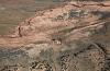
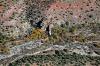
As with any time flying down wilderness canyons it pays to keep eyes outside. Not only is it pretty out there, but spotting the wire traps early is important to celebrating future birthdates. (What the heck are wires doing out in a wilderness?)
Near Pine Mountain, AZ
| | Attachments:
6-54 Low Hazard 0595
| | |
|
Nickens, Dan - Dec 22,2018
Viewers
| Reply
|
| |
Who named this "Pine Mountain"? "Cactus Mountain", sure. Or "Dry Rock" Mountain. Maybe there was a pine or two, but I didn't see any.
Pine Mountain, AZ
| | Attachments:
6-55 Pine Mountain 0608
| | |
|
Nickens, Dan - Dec 22,2018
Viewers
| Reply
|
| |
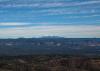
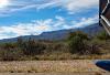
Blue skies, white clouds, fair winds. The only way it could get better is to find some lightly rippled SeaRey water.
Over Pine Mountain Wilderness Area, AZ
| | Attachments:

6-56 Fair Skies 0613
| | |
| | | | | | | | | | | | | | | | | | | | | | | | | | | | | | | | | | | | | | | | | | | | | | | | | | | | | | | | | | | | | | | | | | | | | | | | | | | | | | | |