|
|
 |
|
|
|
|
|
|
|
|
Posted By:
Nickens, Dan
Date Posted:
Dec 7, 2018
Description:
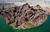
One little photo sent by text changed the course of the day, and indeed, a season. Like the butterfly and the cyclone, it was a tipping point.
The day got off to inauspicious start. The airport loaner truck wouldn't start and I had to summon an Uber driver. When I later talked to the airport manager to explain where I had left his truck he said he knew exactly what was wrong (a loose battery wire).
Finding a route to Seattle was beginning to look more problematic. Though the forecast for present day routing looked marvelous, if a bit windy, Seattle was stuck in the miasma of Aleutian Lows.
Well, that would be a problem for another day. My plan was to get to Las Vegas, then check weather in the Sierra Nevada Mountains before going further north. Early word was winds of 30+ knots would make for an ugly day getting out of Nevada.
Meanwhile, though, clear skies beckoned. Got to fly!
Date Taken:
October 31, 2018
Place Taken:
Lake Havasu, Arizona
Owner:
Nickens, Dan
File Name:
- Photo HTML
Full size - <img src="/show.php?splash=7PgZ1XV0ah">
Medium - <img src="/show.php?splash=7PgZ1XV0am">
Thumbnail - <img src="/show.php?splash=7PgZ1XV0as">
Category:
Flexible Flight Plans
|
|
|
|
|

Click on photo to view the original size. |
| Viewers
|
|
|
|
|
|
|
|
|
|
|
Read what others had to say:
|
|
|
|
|
|
|
 |
Nickens, Dan - Dec 03,2018
Viewers
| Reply
|
| |
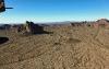
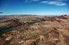
Not far from the Chandler airport was a massive recreational park. It had a drag strip, on and off-road race courses, and, strange for a desert area, a one mile long motorboat racing lake. Adding a seaplane base would be a big plus.
Wild Horse Pass Motorsports Park, Chandler, AZ
| | Attachments:
5-2 Not for Seaplanes 9776
| | |
|
Nickens, Dan - Dec 03,2018
Viewers
| Reply
|
| |
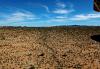
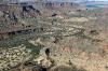
Close to town but not often frequented by visitors is a wilderness area. Perhaps the reason it's rarely visited is because the closer portion of the area is part of the Gila River reservation. Non-natives aren't welcomed.
Sierra Estrella Mountains, AZ
| | Attachments:
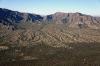
5-3 Urban Mountains 9784
| | |
|
Nickens, Dan - Dec 03,2018
Viewers
| Reply
|
| |
Lush agricultural land is a strange sight in a desert. Thanks to underground resources, aqueducts, and a warm climate, the desert has been transformed. Unfortunately these days the Phoenix aquifer is not replenished as quickly as the water is withdrawn, resulting in dropping water levels and cracking surfaces ("earth fissures" ). But, that was before the fall rains came. Maybe it's gonna get better. (Right.)
West of Phoenix, AZ
| | Attachments:
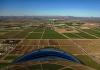
5-4 Phoenix Farms 9796
| | |
|
Nickens, Dan - Dec 03,2018
Viewers
| Reply
|
| |
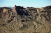
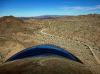
What's a volcano doing at nuclear power plant?
Palo Verde is the largest net generation plant in the U.S. It's nuclear furnaces power Phoenix, Tucson, Los Angeles and San Diego. It is the only nuclear plant not located by a large body of water. Instead the plant uses treated sewage water as coolant.
Fortunately the volcano, sitting right next to sewage ponds, has been cold for 25 million years.
Palo Verde Nuclear Power Plant, near Tonopah, AZ
| | Attachments:
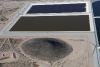
5-5 Powerful Residues 9800
| | |
|
Nickens, Dan - Dec 03,2018
Viewers
| Reply
|
| |
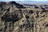
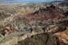
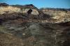
The outbreak of volcanism about 25 millions years back was occasioned by the earth's crust being stretched thin. In some places it just broke open and hot rocks spilled out.
Near Tonopah, AZ
| | Attachments:
5-6a Small Cones 9804
| | |
|
Nickens, Dan - Dec 03,2018
Viewers
| Reply
|
| |
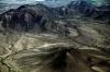
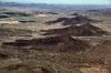
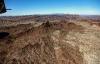
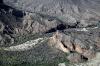
Saddle Mountain is made up of volcanic vents and lava flows. It sits on the western edge of the Tonopah Desert, surrounded by a flat valley. It's elevated topography was a nice break from the wide flat sameness of its surroundings.
Saddle Mountain, AZ
| | Attachments:
5-6b Rough Spot 9813
| | |
|
Nickens, Dan - Dec 03,2018
Viewers
| Reply
|
| |
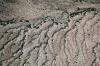
Green Sonoran desert scrub growing along the rarely used drainage was a sure sign of recent rains.
Harquahala Plain, AZ
| | Attachments:
5-7 Desert Drains 9816
| | |
|
Nickens, Dan - Dec 03,2018
Viewers
| Reply
|
| |
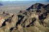
There was more greenery growing in the talus of desert mountains. It had been a very wet season.
Eagle Mountain Wilderness Area, AZ
| | Attachments:
5-8 Western Wilderness 9817
| | |
|
Nickens, Dan - Dec 03,2018
Viewers
| Reply
|
| |
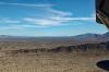
There was a measure of reassurance to be flying by mountains surrounded by broad, gently sloping washes. It would make for a less rocky landing in an emergency.
Eagle Mountain Wilderness Area, AZ
| | Attachments:
5-9 Mountain Meltdown 9826
| | |
|
Nickens, Dan - Dec 03,2018
Viewers
| Reply
|
| |
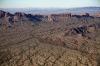
Looks the mountain tops have taken quite a beating in the last 25 million.
Eagle Mountain Wilderness Area, AZ
| | Attachments:
5-10 Ravaged Ridge 9830
| | |
|
Nickens, Dan - Dec 03,2018
Viewers
| Reply
|
| |
The adjoining open spaces allowed for a comfortable up-close tour of the ragged ridges.
Eagle Mountain Wilderness Area, AZ
| | Attachments:
5-11 Hard to Port 9834
| | |
|
Nickens, Dan - Dec 03,2018
Viewers
| Reply
|
Nickens, Dan - Dec 03,2018
Viewers
| Reply
|
| |
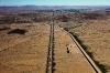
Emergency landing options abound where an interstate highway follows a canal across a flat desert floor.
South of Hope, AZ
| | Attachments:
5-13 Desert Crossing 9837
| | |
|
Nickens, Dan - Dec 03,2018
Viewers
| Reply
|
| |
Lining them up: volcanic vents, including Pyramid Peak.
Southwest of the Little Harquahala Mountains, AZ
| | Attachments:
5-14 Vent Line 9843
| | |
|
Nickens, Dan - Dec 03,2018
Viewers
| Reply
|
Nickens, Dan - Dec 03,2018
Viewers
| Reply
|
| |
Wide open spaces. Interrupted by high walls.
Western end of Granite Wash Mountains and Butler Valley, AZ
| | Attachments:
5-16 Plain Interruption 9853
| | |
|
Nickens, Dan - Dec 03,2018
Viewers
| Reply
|
| |
What to do with your canal when there is a desert wash to cross? Go underground.
Cunningham Wash, near Utting, AZ
| | Attachments:

5-17 Underdrain 9855
| | |
|
Nickens, Dan - Dec 03,2018
Viewers
| Reply
|
| |
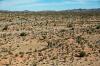
My flat, open emergency field was getting a bit thick with mesquite. I suppose a wet fall could be to blame. But, green mesquite is more limber than dry, right? One can hope.
Cunningham Wash, near Bouse, AZ
| | Attachments:
5-18 Wash Floor 9867
| | |
|
Nickens, Dan - Dec 03,2018
Viewers
| Reply
|
| |
Despite the increasing density of vegetation, a gear up landing didn't look too scary.
Cunningham Wash, near Bouse, AZ
| | Attachments:

5-19 Upclose Floor 9869
| | |
|
Nickens, Dan - Dec 03,2018
Viewers
| Reply
|
| |
Upon closer examination, though, there were lots of unlit towers that could make for a sticky situation.
Cunningham Wash, near Bouse, AZ
| | Attachments:
5-20 Unlit Tower 9872
| | |
|
Nickens, Dan - Dec 03,2018
Viewers
| Reply
|
| |
The cactus towers did seem to be widely dispersed and reasonably spaced for anything other than a blind descent. And, bonus, they would provide emergency water if the airplane engine decided to quit nearby (or so I'm told, or maybe seen in cowboy movies).
Cactus Plain, near Bouse, AZ
| | Attachments:
5-21 Open Desert 9875
| | |
|
Nickens, Dan - Dec 03,2018
Viewers
| Reply
|
| |
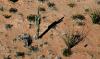
When the washes and flatlands dry up, a wandering seaplane can follow dirt roads through the mountains. (Well, technically I suppose the road runs down a dry wash, but either way it's an easier path through the big rocks.)
Through the Buckskin Mountains, AZ
| | Attachments:
5-22 Running Down Road 9882
| | |
|
Nickens, Dan - Dec 03,2018
Viewers
| Reply
|
| |
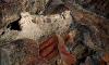
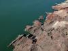
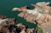
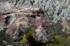
The mountains were mixed up with colors. Colors are indicative of minerals. More clues: the nearby ghost town of Swansea was a mining camp (copper) in the early 1900's.
Mineral Hill near Swansea, AZ
| | Attachments:
5-23 Mixing Colors 9888
| | |
|
Nickens, Dan - Dec 03,2018
Viewers
| Reply
|
| |
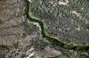
Flowing water with the greenness to prove it.
Bill Williams River near Swansea Wilderness Area, AZ
| | Attachments:
5-24 Green Break 9894
| | |
|
Nickens, Dan - Dec 03,2018
Viewers
| Reply
|
| |
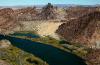
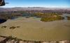
A little stream of water led to a big lake at the intersection of The Mesa Mountains, Bill Williams Mountains, and Bill Williams River, AZ.
Who the heck was Bill Williams that he gets such cool stuff named for him? He was quite the mountain man and explorer. He was a Protestant preacher who translated the Bible to the Osage language. He married a Ute, A-Ci'n-Ga, "Wind Blossum" and had two children. After his wife's death, he worked as an independent tracker and guide. Fremont hired him to do a survey for the trans-continental railway. When Bill told him that it was too late and winter was coming, Fremont went on...to failure. When Bill went in to try and rescue them, he was attacked and killed by Ute warriors.
Now, that's how you get rivers and mountains and towns named after you.
Bill Williams National Wildlife Refuge, AZ
| | Attachments:
5-25 Drain to Lake 9900
| | |
|
Nickens, Dan - Dec 03,2018
Viewers
| Reply
|
| |
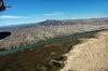
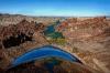
The desert river wandered over a pretty broad plan until it had to get through the mountains. That's when things got tight.
Bill Williams National Wildlife Refuge, AZ
| | Attachments:
5-26 Narrow Outlet 9906
| | |
|
Nickens, Dan - Dec 03,2018
Viewers
| Reply
|
| |
There are mines in them there hills! Someone has to get the minerals to make all the colors of our paints and coppers for our pans.
Mineral Wash, AZ
| | Attachments:
5-27 Painted Place 9909
| | |
|
Nickens, Dan - Dec 03,2018
Viewers
| Reply
|
| |
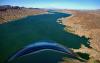
Now this was the picture the seaplane had been searching for since Texas!
Havasu National Wildlife Refuge, near Havasu Springs, AZ
| | Attachments:

5-28 Big Water Ahead 9910
| | |
|
Nickens, Dan - Dec 03,2018
Viewers
| Reply
|
| |
The water at the river mouth looked a bit convoluted and shallow for comfortable SeaRey operations (at least those in someone else's 'Rey).
Bill Williams River mouth at Lake Havasu, AZ
| | Attachments:
5-29 River Mouth 9915
| | |
|
Nickens, Dan - Dec 03,2018
Viewers
| Reply
|
| |
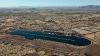
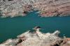
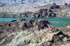
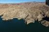
Parker Dam backed up plenty of water for seaplanes to play in Lake Havasu.
Lake Havasu, Parker Dam, on the Colorado River, AZ
| | Attachments:
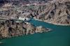
5-30 Water Brakes 9916
| | |
|
Nickens, Dan - Dec 03,2018
Viewers
| Reply
|
| |
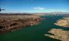
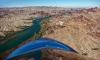
Just look at all those splashing opportunities! The only limiting factor was the strong wind blowing right down the middle of the lake. That, and my plan to get the plane to Seattle sometime during the a timeframe the owner would allow.
Lake Havasu, AZ and CA
| | Attachments:
5-31 Running Upstream 9918
| | |
|
Nickens, Dan - Dec 07,2018
Viewers
| Reply
|
| |
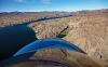
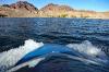
Both the land and water were strongly rippled. Fortunately there were plenty of protected coves to chose from minimizing ripples ashore and afloat.
Lake Havasu, AZ
| | Attachments:
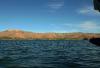
5-32 Rippled 9923
| | |
|
Nickens, Dan - Dec 03,2018
Viewers
| Reply
|
| |
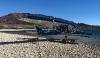
A simple lunch stop provided the opportunity to share the pleasures of SeaReys by text with the new owner.
(Who could guess the consequences of such a mundane gesture! I surely didn't.)
Lake Havasu, AZ
| | Attachments:
5-33 Stepping Out 9925
| | |
|
Nickens, Dan - Dec 03,2018
Viewers
| Reply
|
| |
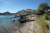
The Bureau of Land Management graciously provided facilities for vagrant seaplanes for a ten dollar fee.
Lake Havasu, AZ
| | Attachments:
5-34 Dining Facilities 9930
| | |
|
Nickens, Dan - Dec 03,2018
Viewers
| Reply
|
| |
Who wouldn't pay $10 to park here? It was quite the bargain! (But maybe more than I had bargained for...as Kenny sang, "You never count your money When you're sittin' at the table." )
Lake Havasu, AZ
| | Attachments:
5-35 Scenic Parking 9938
| | |
|
Nickens, Dan - Dec 03,2018
Viewers
| Reply
|
| |
After a fine time splashing and open air dining, civilization loomed on the horizon. It was an opportunity to feed the airplane.
Lake Havasu State Park, AZ
| | Attachments:
5-36 Edge of Civilization 9949
| | |
|
Nickens, Dan - Dec 03,2018
Viewers
| Reply
|
| |
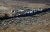
These folks must be good neighbors. They are too densely packed to be bad.
Whipple Point, Havasu Palms, CA
| | Attachments:
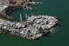
5-37 Circling Wagons 9950
| | |
|
Nickens, Dan - Dec 03,2018
Viewers
| Reply
|
| |
Where the rocks come right down to the water it was a bit too tight for comfortable SeaRey parking.
Lake Havasu State Park, AZ
| | Attachments:
5-38 Sharp Shore 9952
| | |
|
Nickens, Dan - Dec 03,2018
Viewers
| Reply
|
| |
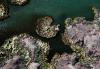
A jig saw puzzle waiting to be solved? The pieces were all in place.
Narrows, Pilot Rock, Lake Havasu, AZ and CA
| | Attachments:
5-39 Narrows 9956
| | |
|
Nickens, Dan - Dec 03,2018
Viewers
| Reply
|
| |
A calm haven from the wind-whipped waves, but a bit too tricky to try in not-my-SeaRey.
Lake Havasu State Park, AZ
| | Attachments:
5-40 Green Coves 9961
| | |
|
Nickens, Dan - Dec 03,2018
Viewers
| Reply
|
| |
There were much bigger coves available. With so much opportunity does it become too common? Nope, but I decided to hold out for optimum situations before squandering my limited time on merely great places.
Lake Havasu, CA and AZ
| | Attachments:
5-41 All Lake Long 9963
| | |
|
Nickens, Dan - Dec 03,2018
Viewers
| Reply
|
| |
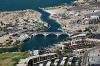
After miles of wilderness there was a sudden explosion of civilization. How did that happen?
Lake Havasu, AZ
| | Attachments:

5-42 Urban Encroachment 9962
| | |
|
Nickens, Dan - Dec 03,2018
Viewers
| Reply
|
| |
It happened because of clever marketing.
In 1962 the British sold the London Bridge to an American oil man. (Obviously he hadn't heard that the much closer Brooklyn bridge was available for a very reasonable price from a lot of sellers.) He shipped the bridge from London to Arizona to promote development of a peninsula (Pittsburgh Point) in Lake Havasu.
Previously the peninsula had been owned by the U.S. government and used as an emergency airfield in WWII. It was given to the state who gave it to the developer. Unfortunately no one wanted to buy property in a hot, arid environment. To attract people the bridge was reconstructed here in 1971. A channel was dredged to give the bridge some functionality, and to make the peninsula into an island. Apparently the prospect of living on an island in an artificially old English-themed community served by a reconstituted London Bridge was just the ticket for a successful development.
Unbelievably, the bridge is currently touted as the second most popular tourist attraction in Arizona after the Grand Canyon. With all the things to see, coming to Arizona to see an old, relocated, bridge is the surest indication of societal degeneration I can imagine.
T.S. Elliot wrote about the bridge falling down in The Waste Land, perhaps referencing its desert fate:
Here is no water but only rock
Rock and no water and the sandy road
The road winding above among the mountains
Which are mountains of rock without water
If there were water we should stop and drink
Amongst the rock one cannot stop or think
Sweat is dry and feet are in the sand
If there were only water amongst the rock
Dead mountain mouth of carious teeth that cannot spit
Here one can neither stand nor lie nor sit
There is not even silence in the mountains
But dry sterile thunder without rain
There is not even solitude in the mountains
But red sullen faces sneer and snarl
From doors of mudcracked houses
If there were water
And no rock
If there were rock
And also water
And water
A spring
A pool among the rock
If there were the sound of water only
Not the cicada
And dry grass singing
But sound of water over a rock
Where the hermit-thrush sings in the pine trees
Drip drop drip drop drop drop drop
But there is no water
......................
I sat upon the shore
Fishing, with the arid plain behind me
Shall I at least set my lands in order?
London Bridge is falling down falling down falling down
Jerry Jeff Walker sang about being in London without the bridge in "London Homesick Blues".
Well, when you're down on your luck
and you ain't got a buck,
in London you're a goner.
Even London Bridge has fallen down
and moved to Arizona;
now I know why.
And I'll substantiate the rumor
that the English sense of humor
is drier than the Texas sand.
You can put up your dukes,
and you can bet your boots,
that I'm leavin' just as fast as I can.
London Bridge, Lake Havasu, AZ
| | Attachments:
5-43 Outta Place 9965
| | |
|
Nickens, Dan - Dec 03,2018
Viewers
| Reply
|
| |
The automated weather told of wind at 18 gusting to 24. It made for a short landing. Flight time covered 2.7 extremely excellent hours from Phoenix (not counting downtime wading in the lake). Though there was some turbulence, I didn't complain about the wind slowing me down. It just gave me more time to appreciated the scenery. Now, if the forecast increase in wind speed proved true, I'd have to avoid the high mountains and deviate west into California before turning north. But, that decision could wait. There was still more lake-like river to fly.
Lake Havasu Airport (KHII), AZ
| | Attachments:
5-44 Lake Wind 9972
| | |
|
Nickens, Dan - Dec 04,2018
Viewers
| Reply
|
| |
A marsh in the desert? Apparently so. Migrating birds certainly could make good use of it when navigating across the dry country.
Approaching Blankenship Bend, Colorado River, AZ
| | Attachments:
5-45 Marshy End 9976
| | |
|
Nickens, Dan - Dec 04,2018
Viewers
| Reply
|
| |
A nice sandbar showed up just past a river bend. On other trips I've found it was packed with boats as I flew by. I was tempted to stop and enjoy the solitude, but the wind was a bit brisk for wading.
Blankenship Bend, Colorado River, AS
| | Attachments:

5-46 Sharp Turn 9985
| | |
|
Nickens, Dan - Dec 04,2018
Viewers
| Reply
|
| |
Eventually the lake narrowed back into a river running through the desert. There were several interesting rocks below, including the Mohave rock, and Picture Rock (with petroglyphs). They would have been worthy of investigation except for the windy water around them.
Colorado River, South of Toprock, AZ
| | Attachments:
5-47 Back to River 9986
| | |
|
Nickens, Dan - Dec 04,2018
Viewers
| Reply
|
| |
The terrain seemed to changed color with every peak and slope.
Colorado River, South of Toprock, AZ
| | Attachments:
5-48 Multi-hued Desert 9991
| | |
|
Nickens, Dan - Dec 04,2018
Viewers
| Reply
|
| |
A strong wind blowing opposite to the current and accelerating through the constriction discouraged any thought of stopping to gawk at the gorge.
Topock Gorge, Mohave Canyon, Colorado River, AZ
| | Attachments:
5-49 Topock Gorge 9996
| | |
|
Nickens, Dan - Dec 04,2018
Viewers
| Reply
|
| |
The sand is actually in a dry river channel that makes an island when water rises.
South of Topock, AZ
| | Attachments:
5-50 Future Beach 0002
| | |
|
Nickens, Dan - Dec 04,2018
Viewers
| Reply
|
| |
Ahead was open country. Fortunately the wind was slowing my departure from the canyon country.
South of Topock, AZ
| | Attachments:
5-51 Canyon Exit 0013
| | |
|
Nickens, Dan - Dec 04,2018
Viewers
| Reply
|
| |
The little beach in the bend would have been a great place to stop on a calmer, less hurried day. (With the increasing headwind I figured I needed to get to Las Vegas sooner rather than later and make a decision on what route north to pursue.)
Chemehuevi Mountains, CA
| | Attachments:
5-52 Around the Bend 0018
| | |
|
Nickens, Dan - Dec 04,2018
Viewers
| Reply
|
| |
Splotches of color were spectacular to see, even in a quick flyby.
Colorado River south of Topock, AZ
| | Attachments:
5-53 Riverside Painting 0020
| | |
|
Nickens, Dan - Dec 04,2018
Viewers
| Reply
|
| |
It takes a master artist to dabble in earth art. This looked to be one of her better works.
Chemehuevi Mountains, CA
| | Attachments:
5-54 Shades of Earth 0021
| | |
|
Nickens, Dan - Dec 04,2018
Viewers
| Reply
|
| |
Crossing the river at Topock is a PG&E gas line connecting fields in west Texas to California and Oregon. Back in the day a solution containing hexavalent chromium was added to reduce corrosion in compressor cooling towers at Topock. After rinsing the towers with the Cr+6 solution it was "disposed of adjacent to the towers" (translation: it was dumped on the ground). The current EPA allowable level for this potent carcinogen is 100 parts per billion (California says the goal should be 0.2 ppb, but some Californians are hypersensitive to that kind of stuff). When the Cr+6 was detected in groundwater in 1997, EPA jumped right on the problem and initiated studies. All that studying has finally come to a tentative conclusion that remediation is needed. Construction of the selected remediation technology started earlier this year and is expected to be completed by 2020. So, 23 years after identifying a problem, cleanup can start in the next few years (unless it is delayed by litigation or technical issues or government shutdown). Your tax dollars at work. Meanwhile, don't drink the water.
Topock, AZ
| | Attachments:
5-55 Crossings 0025
| | |
|
Nickens, Dan - Dec 04,2018
Viewers
| Reply
|
| |
There were huge marshlands just north of Topock. It's big for birds and birders, though I only spotted birds on the weekday fly over.
Topock Marsh, AZ
| | Attachments:
5-56 Marshlands 0030
| | |
|
Nickens, Dan - Dec 04,2018
Viewers
| Reply
|
| |
Though the grade was shallow around the marsh's edges, there was evidence of recent water erosion.
Topock Marsh, Near Catfish Paradise, AZ
| | Attachments:

5-57 Marsh Wash 0028
| | |
|
Nickens, Dan - Dec 04,2018
Viewers
| Reply
|
| |
Laughlin airport has a control tower and I was dutifully in contact with them for my transition up the river. Normally my phone vibrating wouldn't have gotten my attention until I was clear of the zone. The controller was quiet, however, and I took a brief glance to find a text: "Urgent. Call me as soon as possible."
It was from the aircraft owner. My mind raced to figure what could be so urgent. Was he upset by my earlier text picture of the airplane parked on a beautiful beach? It was the last communication with him. Maybe he thought I was having too much fun, using up all the airplane's fun quotient? That may be true but he was forewarned before he handed me the keys.
Well, it was his airplane and if he considered it urgent, I could stop and find out why. I called the tower to let them know I was maneuvering to return for landing.
"Do you have a problem?" the controller asked.
How should I know? Could be, but I doubted the controller would be interested in whatever issue I had with the owner. I told him "No" and requested to "land short". I was pretty sure that would be no issue since the wind was 23 gusting to 35. It wasn't. An issue.
The next concern was that there was only one FBO on the field, and it was a Signature brand. I didn't need fuel and I didn't want to pay any usage fees, so I just parked the airplane as far away as possible. When the lineman approached, I simply pointed at the phone. He sat there watching, but didn't bother me.
The call was urgent. "I saw your picture," the owner said. "It has been raining here for weeks and the forecast is the same for the next ten days. I went through this last year. I don't want to do it again. Can you take the airplane back to Phoenix? I've decided I'm moving."
I wasn't sure he was serious, though he said he was. I told him there was hangar space at P19 where I had stayed overnight and gave him the name of the nice airport manager. I suggested that I proceed to Las Vegas and check in with him again. If he still wanted to move, I'd take the airplane back the next day.
Laughlin, NV, Bullhead City, AZ (KIFP) critical stop after 1.1 hours flying.
| | Attachments:
5-58 Change of Fortune 0039
| | |
|
Nickens, Dan - Dec 04,2018
Viewers
| Reply
|
| |
Just outside the gambling town was a river boat stuck high and dry on a sand bank. I'll bet there was some kind of change of plans for its captain too.
I was conflicted about the possibility of a major change to my plans. On one hand I was disappointed about not making it to Seattle. On the other hand, I wasn't unhappy about trying to navigate the ugly northwest weather. On the best hand, however, I had some time now to play, and an easy trip back to Phoenix in good weather (if that was the final decision).
Near Bullhead City, AZ
| | Attachments:
5-59 Tides Out 0046
| | |
|
Nickens, Dan - Dec 04,2018
Viewers
| Reply
|
| |
When offered a reprieve from schedule, I took it. I stopped in to check out some of the more interesting rocks along the way.
Near Davis Dam (camp) AZ
| | Attachments:
5-60 Hole in Rough 0066
| | |
|
Nickens, Dan - Dec 04,2018
Viewers
| Reply
|
| |
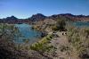
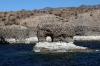
There was time to explore some hard rock beaches.
Lake Mohave near Mt. Davis (Bradshaw Mountains), AZ
| | Attachments:
5-61 Hard Parking 3635
| | |
|
Nickens, Dan - Dec 04,2018
Viewers
| Reply
|
| |
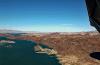
The problem was that there were too many places to stop and explore. Moreover, I knew there were more ahead on Lake Mead. I'd have to get a little pickier or I wouldn't make it to Las Vegas.
Lake Mohave, AZ
| | Attachments:
5-62 Ragged Shore 0088
| | |
|
Nickens, Dan - Dec 04,2018
Viewers
| Reply
|
Nickens, Dan - Dec 04,2018
Viewers
| Reply
|
Nickens, Dan - Dec 04,2018
Viewers
| Reply
|
| |
The appearance of a high wire tempered ideas of frivolous splashing on this stretch. I moved on to open waters ahead.
Lake Mohave, South of Nelson Landings, NV
| | Attachments:
5-65 Wire Trap 0098
| | |
|
Nickens, Dan - Dec 04,2018
Viewers
| Reply
|
| |
In Florida the rocks are layered. That seemed to be the exception out here.
El Dorado Mountains, NV
| | Attachments:
5-66 Mixedup Mountains 0100
| | |
|
Nickens, Dan - Dec 04,2018
Viewers
| Reply
|
| |
So much opportunity! So much time! What to do, what to do. Well, the wind was unpleasant here. I decided to move on up to Lake Mead and see what that was like.
Lake Mead National Recreational Area, Colorado River, NV and AZ
| | Attachments:

5-67 Recreational Opportunities 0103
| | |
|
Nickens, Dan - Dec 04,2018
Viewers
| Reply
|
| |
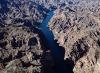
Between the Eldorado Mountains on the west and the Black Mountains of Arizona on the east side, the river was squeezed in the middle. So was the wind, like a wind funnel. It was too much for fun splashing.
Black Canyon, NV and AZ
| | Attachments:

5-68 Canyon Run 0114
| | |
|
Nickens, Dan - Dec 04,2018
Viewers
| Reply
|
| |
The topo map showed multiple hot springs on either side of the river. If it wasn't for the wind, I'd have been looking for one.
Black Canyon, NV and AZ
| | Attachments:
5-70 Thread of Water 0123
| | |
|
Nickens, Dan - Dec 04,2018
Viewers
| Reply
|
| |
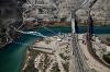
The bridge built in 2010 replaced the old road crossing Hoover dam, bypassing hairpin turns and keeping potential terrorists from messing with the dam.
Near Boulder City, NV
| | Attachments:
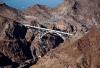
5-71 Secure Crossing 0134
| | |
|
Nickens, Dan - Dec 04,2018
Viewers
| Reply
|
| |
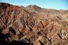
The red spots are known as "Paint Pots"(or "Devil's Paint Pots" to the overly dramatic). Looked more like red ripples to me. They came along with lava flows and plutons that injected mineral rich fluids into Fortification Hill.
Fortification Hill, AZ
| | Attachments:

5-72 Paint Pots 0144
| | |
|
Nickens, Dan - Dec 04,2018
Viewers
| Reply
|
| |
Almost as if someone hit a switch, the wind calmed down as I passed over the dam. All thoughts of waiting for a perfect spot flew away. I took the first available parking sport at the base of Fortification Hill. Turns out the bank was a bit steep for my tastes, so I just sorta parallel parked.
Fortification Hill, AZ
| | Attachments:
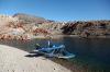
5-73 Backed In 0153
| | |
|
Nickens, Dan - Dec 07,2018
Viewers
| Reply
|
| |
After a short time ashore, I was ready to launch for higher explorations. The pilot-side entry was a bit on the deep side, so I spun the airplane around for easy entry. This plane is so easy its spoils its pilots! "They are just ruined!" as my grandma would say.
Fortification Hill, AZ
| | Attachments:
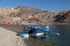
5-74 Launch Position 0160
| | |
|
Nickens, Dan - Dec 04,2018
Viewers
| Reply
|
| |
It wasn't more than a few miles before there was another opportunity for splashing and beaching.
Hamblin Bay, Lake Mead, NV
| | Attachments:
5-75 On Approach 0168
| | |
|
Nickens, Dan - Dec 04,2018
Viewers
| Reply
|
| |
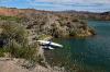
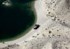
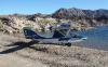
This beach was plenty solid for going completely dry.
Hamblin Bay, Lake Mead, NV
| | Attachments:
5-76 Feet Dry 0170
| | |
|
Nickens, Dan - Dec 04,2018
Viewers
| Reply
|
| |
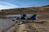
Even with a firm footing, it doesn't hurt to be headed in the right direction. When working at hazardous sites we were always instructed to park our vehicles facing out so that there would be no delay in an expeditious departure. It applies to fun sites too. There shouldn't be a delay when there are so many other opportunities for play.
Hamblin Bay, Lake Mead, NV
| | Attachments:
5-77 Ready Position 0172
| | |
|
Nickens, Dan - Dec 04,2018
Viewers
| Reply
|
| |
A picture of one canyon wall does not provide the adrenaline rush that flying through provides. So, to add another dimension, here's a video showing both sides.
Near Canyon Point, Boulder Canyon, NV
| | Attachments:

Canyon Run
| |
| Attachments:
5-78 Canyon Wall 0182
| | |
| | | | | | | | | | | | | | | | | | | | | | | | | | | | | | | | | | | | | | | | | | | | | | | | | | | | | | | | | | | | | | | | | | | | | | | | | | | | | | | |