|
|
 |
|
|
|
|
|
|
|
|
|
|
|
|
|

Click on photo to view the original size. |
| Viewers
|
|
|
|
|
|
|
|
|
|
|
Read what others had to say:
|
|
|
|
|
|
|
 |
Nickens, Dan - Nov 27,2018
Viewers
| Reply
|
| |
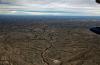
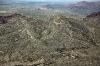
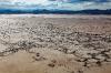
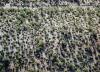
The land approaching the Guadalupe Mountains was highly eroded, exposing the layered rock underlying the Llano Estacado. There were lots of intricate squiggles.
West of Carlsbad, NM
| | Attachments:
4-2 Lined Land 9142
| | |
|
Nickens, Dan - Nov 27,2018
Viewers
| Reply
|
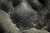
| |
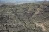
The ground seemed to be some kind of giant Rorshach test. All the determinants were there: form (wrinkled), color (mostly gray), movement (slow), and even shading (tan to gray) . I don't know what this means, but I was somewhat attracted to this form, but wished to remain a bit aloof, only not so much as to enter the gray mists overhead.
West of Carlsbad, NM
| | Attachments:

4-3 Layered Hills 9146
| | |
|
Nickens, Dan - Nov 27,2018
Viewers
| Reply
|
| |
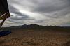
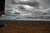
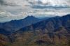
The closer I got to the clouds, the nastier they looked. And the clouds were squeezed by the top of the mountains at 7000'.
Guadalupe Mountains West of Carlsbad, NM
| | Attachments:

4-4 Closing on Clouds 9152
| | |
|
Nickens, Dan - Nov 27,2018
Viewers
| Reply
|
| |
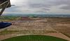
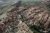
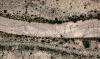
Approaching the crest there were some deep canyons.
Guadalupe Mountains West of Carlsbad, NM
| | Attachments:

4-5 Canyon Cuts 9156
| | |
|
Nickens, Dan - Nov 27,2018
Viewers
| Reply
|
| |
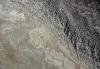
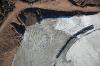
Inside the rough, steep gray canyons were flashes of orange, red and green.
Guadalupe Mountains West of Carlsbad, NM
| | Attachments:

4-6 Rough Places 9165
| | |
|
Don Maxwell - Nov 27,2018
Viewers
| Reply
|
| |
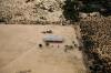
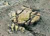
Hm. Not an inviting place to land and have a picnic in that grove.
| | |
|
Nickens, Dan - Nov 27,2018
Viewers
| Reply
|
| |
Flying over massive old Permian reefs, lifted 2 miles above sea level where they formed, was a good reminder that change happens, sometimes slow, sometimes fast, and sometimes so slow that no one will ever notice because extinction or evolution will intervene.
Guadalupe Mountains, NM
| | Attachments:

4-7 Over the Top 9175
| | |
|
Nickens, Dan - Nov 27,2018
Viewers
| Reply
|
| |
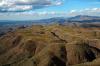
The contours on the west side of the mountains were much steeper. That's because the west side of the mountains are "Brokeoff". (Whoever came up with that name must have been standing at the edge of a cliff when the rock broke off and they bumped their head falling down.)
Brokeoff Mountains, NM
| | Attachments:

4-8 Steep Contours 9178
| | |
|
Nickens, Dan - Nov 27,2018
Viewers
| Reply
|
| |
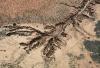
There's no easy path for water running down these hills.
Brokeoff Mountains, NM
| | Attachments:

4-9 Dry Cuts 9180
| | |
|
Nickens, Dan - Nov 27,2018
Viewers
| Reply
|
| |
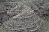
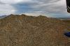
The contours reminded me of hills in middle Tennessee or New Zealand that had been trampled by sheep and cattle, only these were much more pronounced paths, perhaps made by gigantic pre-historic buffalo herds?
Brokeoff Mountains, NM
| | Attachments:
4-10 One Lobe 9183
| | |
|
Don Maxwell - Nov 27,2018
Viewers
| Reply
|
| |
Contour shepherding?
| | |
|
Nickens, Dan - Nov 27,2018
Viewers
| Reply
|
| |
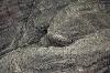
There was an excellent plane path downhill courtesy of erosion.
Brokeoff Mountains, NM
| | Attachments:

4-11 Going Downhill 9186
| | |
|
Nickens, Dan - Nov 27,2018
Viewers
| Reply
|
Nickens, Dan - Nov 27,2018
Viewers
| Reply
|
| |
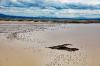
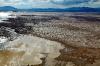
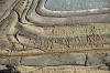
The untrammeled salt had interesting patterns evidencing flat surface evaporation and deposition.
Linda Lake, near Dell City, TX
| | Attachments:
4-13 Lake Bed 9194
| | |
|
Nickens, Dan - Nov 27,2018
Viewers
| Reply
|
| |
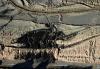
Green agriculture in the Chichuahaun Desert? Sure. An underground source of fresh water was found by oil wildcatters. Unfortunately for the greenery, it's a limited resource. Many formerly green circles have been left to the harsh dryness of the desert.
Near Dell City, TX
| | Attachments:
4-14 Desert Ag 9204
| | |
|
Nickens, Dan - Nov 27,2018
Viewers
| Reply
|
| |
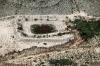
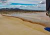
An impoundment meant to capture the occasional trickle of water from rainfall failed spectacularly in recent downpours. You can kinda see the design problem. It was made with the assumption that there would only be a little rain, occasionally. It's a desert, right? But then there's a monsoon and the impoundment overflows and there is no concrete spillway and so.....
West of Dell City, TX, and east of the Cornudas Mountains
| | Attachments:
4-15 Bad Spill 9210
| | |
|
Nickens, Dan - Nov 27,2018
Viewers
| Reply
|
| |
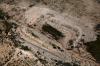
Apparently there's a re-occurring design defect.
West of Dell City, TX, and east of the Cornudas Mountains
| | Attachments:
4-16 Another Overflow 9216
| | |
|
Nickens, Dan - Nov 27,2018
Viewers
| Reply
|
| |
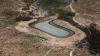
This one withstood the deluge. It's advantage appears to be having a lateral inlet. Or maybe it was just closer to the headwaters of the wash and so there would have been less water?
West of Dell City, TX, and east of the Cornudas Mountains
| | Attachments:
4-17 Good Design 9222
| | |
|
Nickens, Dan - Nov 27,2018
Viewers
| Reply
|
| |
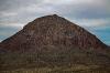
Sticking up out of the vast grasslands of the desert like a sore thumb was a volcanic cone. It really stuck out too, because the Otera Mesa is almost million acre of pretty flat grassland on the northern edge of the Chihuahuan desert.
Wind Mountain, NM
| | Attachments:
4-18 Wind Mountain 9218
| | |
|
Nickens, Dan - Nov 27,2018
Viewers
| Reply
|
| |
When volcanoes start erupting regular sedimentary contour lines get twisted and funky. They could have gone all bluesy from faulting too.
Hueco Mountains, TX
| | Attachments:
4-19 Messed Up Lines 9227
| | |
|
Nickens, Dan - Nov 27,2018
Viewers
| Reply
|
| |
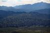
Getting up close to the mountains some of the untwisted bands became more prominent.
Hueco Mountains, TX
| | Attachments:
4-20 Banded Mountains 9234
| | |
|
Nickens, Dan - Nov 27,2018
Viewers
| Reply
|
| |
A few prominent bands indicate longer periods of depositional sameness. The critters living in those times must have thought that climates never change. Then, bam!..... their descendants are in a different layer.
Hueco Mountains, TX
| | Attachments:
4-21 Thick Bands 9239
| | |
|
Nickens, Dan - Nov 27,2018
Viewers
| Reply
|
| |
It would be pretty awesome to be camping in the wash and looking up at the massive cliffs...unless a big rock come loose.
Hueco Mountains, TX
| | Attachments:
4-22 Crusty Canyon 9244
| | |
|
Nickens, Dan - Nov 27,2018
Viewers
| Reply
|
| |
Beyond the banded mountains, things got a lot more messed up. Could be the fault of the fault that pushed up the mountains.
Beside the Hueco Mountains, TX
| | Attachments:
4-23 Crevices 9253
| | |
|
Nickens, Dan - Nov 27,2018
Viewers
| Reply
|
| |
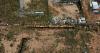
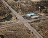
This homeowner has the low maintenance yard thing down to an art.
East of Newman, TX
| | Attachments:
4-24 No Mowing 9262
| | |
|
Nickens, Dan - Nov 27,2018
Viewers
| Reply
|
| |
The Hueco Bolson is a collection of unconsolidated sediments up to 9000' thick that provide the drinking water for El Paso, Ciudad Juarez, the Fort Bliss military facility and multiple small settlements in far west Texas and southern NM. Because of the arid environment of the Chihuahuan desert, it is only slowly recharged. Use of the heavily pumped resource has drastically dropped the water level. The Rio Grande used to be recharged by the aquifer, but no more, and now it leaks into the dry strata below unless lined with concrete.
East of Newman, TX
| | Attachments:

4-25 Pink Plains 9269
| | |
|
Nickens, Dan - Nov 27,2018
Viewers
| Reply
|
| |
The sediments of Hueco Bolson are mostly silts and clays, which is why the recent rains were still in evidence in the road and its bypasses.
East of Newman, TX
| | Attachments:
4-26 Serious Potholes 9275
| | |
|
Nickens, Dan - Nov 27,2018
Viewers
| Reply
|
| |
North was looking ugly, and it was ugly a lot closer to my flight path than the weatherman had predicted. There was no going south. That would mean an international border crossing. No so good these days.
East of Newman, TX
| | Attachments:
4-27 No Go North 9278
| | |
|
Nickens, Dan - Nov 27,2018
Viewers
| Reply
|
| |
A protest against school busing? Or just a different kind of barrier? Could be a cheap border wall. The bonus would be the kids would have to walk two miles to school, making for a tougher, more fit generation?
Newman, TX
| | Attachments:
4-28 No School Zone 9283
| | |
|
Don Maxwell - Nov 27,2018
Viewers
| Reply
|
| |
That's bizarre! Why? How?
| | |
|
Nickens, Dan - Nov 28,2018
Viewers
| Reply
|
| |
One possibility is that it was an accident. All the buses left school at the same time and were following each other down hill. Unfortunately the road was flooded and they had to go off road behind some houses. Suddenly a wild burro broke out of his corral and ran in front of them. The first bus was driven by a nearly blind horse lover who threw on brakes causing a massive six bus pileup. Now the buses were stuck and the flash flooding was getting worse. The drivers evacuated, captured the burro, and rode him back to the school house. Unfortunately the ditch on the right side of the buses was rapidly eroding. When the right side washed away, the buses fell over on their side. As the flood subsided the washed out ditch filled back up with silt and clay, locking the wrecked buses where they fell. There is ongoing litigation between the owner of the allegedly defective corral and the school district that employed a nearly blind driver as to who is responsible for the mess. The buses are being left in place for the jury to see the improbable result of the rampaging water and burros. A verdict is expected in 2024.
| | |
|
Don Maxwell - Nov 28,2018
Viewers
| Reply
|
| |
Well, that sounds plausible. Must be so!
| | |
|
Nickens, Dan - Nov 27,2018
Viewers
| Reply
|
| |
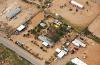
Most yards in the desert were just dirt. This one was a bit more elaborate. The matching green of the swimming pool is a nice touch.
Is it unduly prying to observe private spaces when flying low and slow in a SeaRey? Legally I suppose that if the observer is maintaining a legal altitude above backyards there should be no expectation of privacy. Morally I suppose there is some risk of being rude. I didn't circle, but I didn't yell down apologies as I flew over either.
Newman, TX
| | Attachments:
4-29 Garden Spot 9285
| | |
|
Nickens, Dan - Nov 27,2018
Viewers
| Reply
|
| |
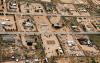
Residents of Newman tended to place value in rectangular spaces, but not necessarily neatness.
Newman, TX
| | Attachments:
4-30 Regular Places 9286
| | |
|
Nickens, Dan - Nov 27,2018
Viewers
| Reply
|
| |
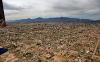
A desert town has a look all its own. It looks like tough living.
I'm pretty sure a distant look isn't rude. Maybe clicking on the picture view and zooming in might negate that premise. Sorry.
Newman, TX
| | Attachments:
4-31 Desert Town 9289
| | |
|
Nickens, Dan - Nov 27,2018
Viewers
| Reply
|
| |
Staring isn't rude if you're just envious of all possibilities of transportation.
Newman, TX
| | Attachments:

4-32 Limited Parking 9290
| | |
|
Nickens, Dan - Nov 27,2018
Viewers
| Reply
|
| |
Not a junkyard! Just an eclectic collection of trucks, tractors, cars, boats and even a helicopter. Too bad they didn't have any place for me to land and check it out.
Newman, TX
| | Attachments:

4-34 Vehicular Variety 9319
| | |
|
Don Maxwell - Nov 27,2018
Viewers
| Reply
|
| |
Not a junkyard, eh? That doesn't say much for that part of Texas, then, Dan.
| | |
|
Nickens, Dan - Nov 28,2018
Viewers
| Reply
|
| |
How can it be a junkyard, Don? It has a helicopter. And lots of cool trucks and other things. That says a lot!
| | |
|
Nickens, Dan - Nov 27,2018
Viewers
| Reply
|
| |
Talus surrounding the high hills is an obvious source for the Hueco Bolson in the twisted fault block mountains.
Franklin Mountains, Texas
| | Attachments:
4-35 Shedding 9323
| | |
|
Nickens, Dan - Nov 27,2018
Viewers
| Reply
|
| |
Faulting deformed the sedimentary rocks in Anthony's nose (somebody named the mountain that...probably Anthony's brother...and I bet he still laughs about it).
North Anthony's Nose, Franklin Mountains, NM
| | Attachments:
4-36 Sharply Wrinkled 9328
| | |
|
Nickens, Dan - Nov 27,2018
Viewers
| Reply
|
Nickens, Dan - Nov 27,2018
Viewers
| Reply
|
| |
For such a fabled river the Rio Grande was pretty much used up south of Las Cruces. Between water diversions and draining of the aquifer, there's not much excess water left to runoff with.
Near Las Cruces, NM
| | Attachments:

4-38 Mostly Dry 9344
| | |
|
Nickens, Dan - Nov 27,2018
Viewers
| Reply
|
| |
There's not much chance of mistaken the nearby closed airport for the active airport at Las Cruces. I arrived at the open airport (KLRU) after 2.7 hours flying from Carlsbad, just in time for lunch. The nice FBO had popcorn in a genuine movie theatre popper. Perfect.
They also had a TV tuned to the Weather Channel. I stopped chomping on my popcorn when I saw a "Winter Storm Warning" flash on screen for El Paso.
"That can't be right!" I asserted in front of the lady taking my credit card for fuel.
"Sadly, it is," she replied. "Looks like we'll get some snow tonight. Don't think it'll stick around long though."
I definitely wasn't sticking around to find out! I raced to the plane, ready to head west. Unfortunately the tail wheel was looking pretty threadbare on one side. Risk having a flat or preemptively rotate it was the question. Throw in the risk of snow, and it was tipping towards fly on. It wasn't my airplane, though. As quickly as I could do it, I rotated the tire and then flew on.
Stahmann Farms Airfield, Near San Miguel, NM (Not the Las Cruces airport)
| | Attachments:
4-39 Xed Airport 9348
| | |
|
Nickens, Dan - Nov 28,2018
Viewers
| Reply
|
| |
The Florida Mountains are nothing like the Florida I know. The skies weren't Florida blue either. There is a "Rockhound State Park" nearby that advertises great rock collecting. Given the sky condition, I didn't think it would be prudent to stop and see.
SE of Deming, NM
| | Attachments:
4-40 Not Like Florida 9368
| | |
|
Nickens, Dan - Nov 28,2018
Viewers
| Reply
|
| |
It's the middle of the desert. There was nothing of significance anywhere nearby. I have no idea why the roads have to be so complicated. Maybe it's another massive Rorshach test?
East of Deming, NM
| | Attachments:

4-41 Its Complicated 9377
| | |
|
Nickens, Dan - Nov 28,2018
Viewers
| Reply
|
| |
The clouds kept getting lower. Fortunately I was still over the Chichuahuan desert, so I could get lower too.
Near Gage, NM
| | Attachments:
4-42 Down with Gophers 9391
| | |
|
Nickens, Dan - Nov 28,2018
Viewers
| Reply
|
Nickens, Dan - Nov 28,2018
Viewers
| Reply
|
| |
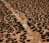
Widely spaced tracks crossing the wash indicated these cattle were an antisocial bunch. Or they didn't like being crowded. Wonder if the cows feel a bit like the cowboys:
Don't Fence Me In, as sung by the original singing cowboy, Gene Autry,
O give me land, lots of land, and the starry skies above
Don't fence me in
Let me ride through the wide open country that I love
Don't fence me in
Let me be by myself in the evening breeze
Listen to the murmur of the cottonwood trees
Send me off forever but I ask you please
Don't fence me in
Just turn me loose, let me straddle my on saddle
Underneath the western skies
On my cayuse, let me wander over yonder
Till I see the mountains rise
I want to ride to the ridge where the West commences
To many words, gaze at the moon till I lose my senses
Can't look at hobbles and I can't stand fences
Don't fence me in
O give me land, lots of land, and the starry skies above
Don't fence me in
Let me ride through the wide open country that I love
Don't fence me in
Let me be by myself in the evening breeze
Listen to the murmur of the cottonwood trees
Send me off forever but I ask you please
Don't fence me in
Just turn me loose, let me straddle my on saddle
Underneath the western skies
On my cayuse, let me wander over yonder
Till I see the mountains rise
I want to ride to the ridge where the West commences
Gaze at the moon till I lose my senses
Can't look at hobbles and I can't stand fences
Don't fence me in
Songwriter: COLE PORTER
| | Attachments:
4-44 Crossing Tracks 9405
| | |
|
Nickens, Dan - Nov 28,2018
Viewers
| Reply
|
| |
When this water didn't know which way to go, it just went down. Not east. Not west. Just down. (The Continental Divide passes on a north-south trend along the Pyramid Mountains.)
Near Lordsburg, NM
| | Attachments:
4-45 Change of Direction 9412
| | |
|
Nickens, Dan - Nov 28,2018
Viewers
| Reply
|
| |
You know there's been a lot of rain in the desert when even the rocks are turning green.
North of Pyramid Mountain, NM
| | Attachments:
4-46 Green Rocks 9427
| | |
|
Nickens, Dan - Nov 28,2018
Viewers
| Reply
|
| |
The water here doesn't go east or west. It just stays around until it evaporates. And, a bit of blue sky was breaking through the clouds. Maybe it wasn't going to get any wetter any time soon.
Kathrine Playa, NM
| | Attachments:
4-47 Almost Wet 9447
| | |
|
Nickens, Dan - Nov 28,2018
Viewers
| Reply
|
| |
Someone with local knowledge put a corral on the only dry spot around in a normal dry lake.
Kathrine Playa, NM
| | Attachments:
4-48 Dry Spot 9461
| | |
|
Nickens, Dan - Nov 28,2018
Viewers
| Reply
|
Nickens, Dan - Nov 28,2018
Viewers
| Reply
|
| |
Some of the salt blocks were getting fully saturated.
Kathrine Playa, NM
| | Attachments:

4-50 Salt Blocks 9472
| | |
|
Nickens, Dan - Nov 28,2018
Viewers
| Reply
|
Nickens, Dan - Nov 28,2018
Viewers
| Reply
|
| |
It was the edge of wetness on the ground and in the sky.
Kathrine Playa with Peloncillo Mountains Wilderness Area, NM & TX Border
| | Attachments:
4-52 Edge of Wet 9485
| | |
|
Nickens, Dan - Nov 28,2018
Viewers
| Reply
|
| |
It's hard to say that there is disappointment when looking out upon scenery like this, but there were supposed to be sky islands out there. Not just any old sky islands, Madrean Sky Islands: remnants of pine-oak woodlands from a pre-glacier climate. The theory is that these woodlands used to be widespread in the area until the climate started warming and drying after the last ice ages. Now they reportedly occur in patches on the slopes of mountains between the hot Chichuahuan desert and the cool mountain tops of the Peloncillo Mountains. Just another victim of climate change, only not associated with industrial man. (But maybe it was bison flatuation that killed the last ice age?) Anyway, there were no such islands visible. Just little bald mountains, reflecting the English translation of Peloncillo.
Near Steins, NM
| | Attachments:

4-53 No Sky Island 9493
| | |
|
Nickens, Dan - Nov 28,2018
Viewers
| Reply
|
| |
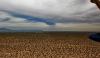
The water up and down was nothing but ephemeral. On the ground the San Simon River sometimes runs through the San Simon Valley. In the air the clouds that might have generated rain were definitely fading to blue.
Near San Simon, AZ
| | Attachments:
4-54 Ephemeral Water 9499
| | |
|
Nickens, Dan - Nov 28,2018
Viewers
| Reply
|
| |
Who can pass up Cochise Head and hoodoos in the Chiricahua National Monument? Reluctantly, I did. It looked like I was getting ahead of the weather and I'd rather be flying most any place as opposed to sitting in a hotel looking at the rain.
Near Dos Cabezas, AZ
| | Attachments:
4-55 Chiricahua Monument 9505
| | |
|
Nickens, Dan - Nov 28,2018
Viewers
| Reply
|
| |
It may not look like much of a lake these days, but back in the Pleistocene weather was different. The exposed flat spot was part of pluvial Lake Cochise. Cloudy, cool air from glaciers provided more precipitation than evaporation, and, presto chango, instant lakefront property.
Wilcox Playa, AZ
| | Attachments:
4-57 Lake Remnants 9530
| | |
|
Nickens, Dan - Nov 28,2018
Viewers
| Reply
|
| |
The playa is a wildlife area, home to sandhill cranes and tiger beetles. I didn't see either, and it's off-limits to people (civilians, anyway). It was once used as a bombing range. Why else would there be a bulls eye in the middle of it?
Wilcox Playa, AZ
| | Attachments:
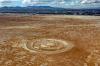
4-59 Bomb Here 9546
| | |
|
Nickens, Dan - Nov 28,2018
Viewers
| Reply
|
| |
Just north of the playa was P33, Cochise County airport. I stopped there after flying 2.7 hours since leaving Las Cruces for fuel.
It could have been a home coming for a prodigal son. The lady that ran the FBO was so friendly, and the place had the cozy feel of a private residence opened up to pilots passing through. All manner of paraphernalia adorned the walls. Soft, welcoming seats and snacks were waiting. Even more impressive was the huge assortment of aviation stuff stashed here and there in no discernible order. No matter, the airport mother knew where to find anything to do with airplanes stashed in her FBO.
"Have you looked at the weather, sweetie?" she asked.
"Yes, maim."
"Well, if those clouds get any lower you'll do better flying up the Gila River valley to get to Phoenix. Once you get over that rise to the northwest, the valley will take you there. That's how folks around here get through, anyway."
"Yes, maim."
The FBO is Walden Aviation. I didn't know they made them this good anymore. Drop in before it's gone.
Cochise Co. Airport (P33), Wilcox, AZ
| | Attachments:
4-60 Minor Deviation 9563
| | |
|
Nickens, Dan - Nov 28,2018
Viewers
| Reply
|
| |
This place is a fantasy for folks that like to go fast. A private race course with an associated airport and luxury cabins would make for a great escape from the mundane, with some great classic jets to inspire faster laps. (Have you raced here yet, Bruce? Can I tag along if you go back?)
West of Wilcox, AZ
| | Attachments:

Inde Motorsports Ranch
| |
| Attachments:
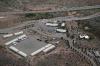
4-61 Big Boy Toys 9567
| | |
|
Nickens, Dan - Nov 28,2018
Viewers
| Reply
|
| |
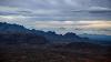
There was no worry about mountain obscuration. The weather was getting better making for a smooth crossing.
Winchester Mountains east of Redington, AZ
| | Attachments:
4-62 Smooth Crossing 9574
| | |
|
Nickens, Dan - Nov 28,2018
Viewers
| Reply
|
| |
Looking at rugged hills from the comfort of a river valley made me happy I followed the advice of my Cochise County flight advisor.
Galiuro Mountains and San Pedro River Valley near Redington, AZ
| | Attachments:
4-63 Side Walls 9583
| | |
|
Nickens, Dan - Nov 28,2018
Viewers
| Reply
|
| |
It's not a mortal wound, but it is a serious laceration.
Near San Manuel, AZ
| | Attachments:
4-64 Red Wound 9608
| | |
|
Nickens, Dan - Nov 28,2018
Viewers
| Reply
|
Nickens, Dan - Nov 28,2018
Viewers
| Reply
|
| |
In the late afternoon sun the bridge appeared a lot taller than it was (and, no, I didn't check to see by trying to fly under it).
Near Mammoth, AZ
| | Attachments:

4-66 Dry Crossing 9616
| | |
|
Nickens, Dan - Nov 28,2018
Viewers
| Reply
|
| |
Prospects for an unscratched off-road landing looked pretty suspect along the valley road.
San Pedro River Valley, North Mammoth, AZ
| | Attachments:
4-67 Prickly Situation 9633
| | |
|
Nickens, Dan - Nov 28,2018
Viewers
| Reply
|
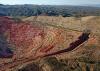
| |
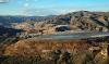
Arizona mines produce 65% of U.S. copper. The Christmas mine was up the hill and ore came down to Hayden for smelting. The leftovers were dumped in ponds along the river valley and left to dry out as best they could.
Near Winkelman, AZ
| | Attachments:
4-68 Fractured Tailings 9657
| | |
|
Nickens, Dan - Nov 28,2018
Viewers
| Reply
|
| |
Sides of the tailings pond had suffered some serious erosion in the recent wetness.
Near Hayden, AZ
| | Attachments:
4-69 Side Issues 9668
| | |
|
Nickens, Dan - Nov 28,2018
Viewers
| Reply
|
| |
The cover had been pierced and it was bleeding black. Not a good sign.
Near Hayden, AZ
| | Attachments:
4-70 Bleeding Black 9669
| | |
|
Nickens, Dan - Nov 28,2018
Viewers
| Reply
|
| |
The ponds down river were getting pretty full. Not much further north asbestos tailings at Globe, Arizona made for one of the most notorious Superfund site. The tailings were used to level out a wash so that a mobile home park could be put there. Turns out that was a really bad idea.
Near Kelvin, AZ
| | Attachments:
4-71 Brim Full 9682
| | |
| | | | | | | | | | | | | | | | | | | | | | | | | | | | | | | | | | | | | | | | | | | | | | | | | | | | | | | | | | | | | | | | | | | | | | | | | | | | |