|
|
 |
|
|
|
|
|
|
|
|
|
|
|
 Favorite option: If you want this item to be marked as a favorite, click on the black heart.
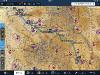
KJCT Departure (Reunion Flight Day 3 Run 1)
Favorite option: If you want this item to be marked as a favorite, click on the black heart.
KJCT Departure (Reunion Flight Day 3 Run 1) |
|
Make Cover Photo
Clear Cover Photo
|
|

Click on photo to view the original size. |
| Viewers
|
|
|
|
|
|
|
|
|
|
|
Read what others had to say:
|
|
|
|
|
|
|
 |
Nickens, Dan - Oct 14,2018
Viewers
| Reply
|
| |
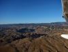
It took only minutes from downtown Grand Junction to get into the spectacular countryside.
Colorado River Valley, East of Grand Junction, CO 9/22
| | Attachments:
Grand Valley IMG 0435
| | |
|
Nickens, Dan - Oct 14,2018
Viewers
| Reply
|
| |
The red rocks and green of the river valley were resplendent under the cloudless sky.
Colorado River Valley, East of Grand Junction, CO 9/22
| | Attachments:
Water Colors IMG 0446
| | |
|
Nickens, Dan - Oct 14,2018
Viewers
| Reply
|
| |
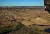
In such a big land the confined parcels along a little stream seemed out of place.
Near Delta, CO 9/22
| | Attachments:
Strange Pastures IMG 0450
| | |
|
Nickens, Dan - Oct 14,2018
Viewers
| Reply
|
| |
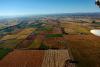
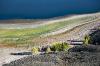
In between the river valley and canyons and mountains there was room for some flat fields
Farms east of Delta, CO 9/22
| | Attachments:

Different Fields IMG 0456
| | |
|
Nickens, Dan - Oct 14,2018
Viewers
| Reply
|
| |
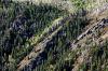
My memory of earlier flights recalled high, hard mountains to climb through. Crossing soft farmlands made the flying through Rockies seem too easy.
Farms east of Delta, CO 9/22
| | Attachments:
Valley Farms IMG 0462
| | |
|
Nickens, Dan - Oct 14,2018
Viewers
| Reply
|
| |
The wrinkled topography adjoining the farmland was a reminder that real mountains were still waiting to be crossed.
East of Delta, CO 9/22
| | Attachments:
Wrinkled Edges IMG 0473
| | |
|
Nickens, Dan - Oct 14,2018
Viewers
| Reply
|
| |
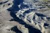
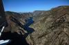
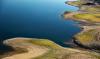
The easy, relaxing near flatness of the early flight was jarred into the past upon confronting the Black Canyon of the Gunnison River. From a casual glance at the chart I had thought it would be like the friendly canyons of Utah. No way. This canyon was a sinister black crevice.
Black Canyon of the Gunnison National Mon., CO 9/22
| | Attachments:
Shocking Crack IMG 0478
| | |
|
Nickens, Dan - Oct 14,2018
Viewers
| Reply
|
| |
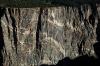
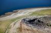
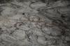
The sheer, sharp walls were granite gray. The water was shallow and rocky. The river course twisted torturously, with no freedom of movement. There was no safe harbor should the little seaplane become distressed.
Black Canyon of the Gunnison National Mon., CO 9/22
| | Attachments:
No Safe Haven IMG 0483
| | |
|
Nickens, Dan - Oct 14,2018
Viewers
| Reply
|
| |
It's called the Black Canyon because it's hard for sunlight to penetrate to the bottom. "Several canyons of the American West are longer and some are deeper, but none combines the depth, sheerness, narrowness, darkness, and dread of the Black Canyon."
From Images of America: The Black Canyon of the Gunnison by Duane Vandenbusche
It is said that the deep water of the canyon gets less than an hour of sunlight every day. Seemed likely true to me.
Black Canyon of the Gunnison National Mon., CO 9/22
| | Attachments:
Dark Shadows IMG 0485
| | |
|
Nickens, Dan - Oct 14,2018
Viewers
| Reply
|
| |
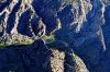
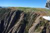
It's called the Painted Wall. A metamorphic rock of PreCambrian age with pegmatite dikes standing more than 2,000' tall. Why did the river cut so cleanly through such tough rock, instead of just going around it?
Because it's path was locked. For millions of easy years the river cut through soft volcanic rock. When the whole area was uplifted, it was forced to scour the hard gniess and schist, though at a slower rate of about an inch per 100 years. Working as hard as the river could, it took 2 million years to cut away this slab.
There were precautionary warnings posted on the park service web site: "Closure Due to Potential Rockfall! Part of South Chasm View Wall is closed due to a 300' x 40' slab of rock that shifted one inch in one week. The slab is estimated to weigh 6 million pounds or more." One of the routes closed was named "The Night is Dark & Full of Terrors". Who would want to take that route anyway!
Black Canyon of the Gunnison National Mon., CO 9/22
| | Attachments:
Sheer Tall Slab IMG 0502
| | |
|
Nickens, Dan - Oct 14,2018
Viewers
| Reply
|
| |
Instead of flying over the canyon, a slight shift to the side put the little airplane over less scary terrain.
Black Canyon of the Gunnison National Mon., CO 9/22
| | Attachments:

Edge of Fright IMG 0511
| | |
|
Nickens, Dan - Oct 14,2018
Viewers
| Reply
|
| |
The slightly less scary edges had a pretty side.
Black Canyon of the Gunnison National Mon., CO 9/22
| | Attachments:
Pretty Unfriendly IMG 0523
| | |
|
Nickens, Dan - Oct 14,2018
Viewers
| Reply
|
| |
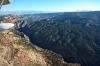
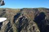
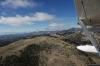
With the edges reaching an elevation of almost 10,000', getting on top was sometimes a stretch.
Black Canyon of the Gunnison National Mon., CO 9/22
| | Attachments:
Out of Reach IMG 0529
| | |
|
Nickens, Dan - Oct 14,2018
Viewers
| Reply
|
| |
Just when I thought I might relax being high enough for some gliding room, the edges went all knarly.
Black Canyon of the Gunnison National Mon., CO 9/22
| | Attachments:

Unflat IMG 0540
| | |
|
Nickens, Dan - Oct 14,2018
Viewers
| Reply
|
| |
The other side of the canyon was higher and too far for an emergency glide. Fortunately so far there was no indication of even the possibility for such a need from my old SeaRey friend.
Black Canyon of the Gunnison National Mon., CO 9/22
| | Attachments:
Outta Reach IMG 0553
| | |
|
Nickens, Dan - Oct 14,2018
Viewers
| Reply
|
| |
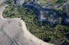
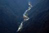
Finally! "Open" water suitable for SeaReys!
A good look convinced me otherwise. While there was room, the wind whipped surface told me that it would be no easy alighting, with a powerful channeled wind blowing ever which way.
Gunnison River near Cimarron, CO 9/22
| | Attachments:
Bad Water IMG 0557
| | |
|
Nickens, Dan - Oct 14,2018
Viewers
| Reply
|
| |
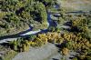
With more water below, the bluffs opened up to some high meadow. An easier escape if one were needed.
Near Cimarron, CO 9/22
| | Attachments:
Easier Crossing IMG 0571
| | |
|
Nickens, Dan - Oct 14,2018
Viewers
| Reply
|
| |
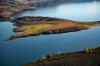
Finally! Beautiful water to splash! I was out of the park and into the national recreation area. There were boats recreating. A flying boat would look really good on the enticing water of the Blue Mesa Reservoir. Sure, it's high at 7000' msl (and higher in density altitude), but with a trusty, capable airplane, it should be good to go.
Wrong! It is closed to seaplanes (according to SPA's water directory). Arbitrary banning! Capricious closing! There is no justice!
Being civilly disobedient I got within an inch of the water but didn't touch (at least that's my testimony and that I didn't feel a thing, certainly no remorse).
Blue Mesa Reservoir, CO 9/22
| | Attachments:
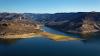
Not for Seaplanes IMG 0583
| | |
|
Nickens, Dan - Oct 14,2018
Viewers
| Reply
|
| |
Perfect SeaRey ramps, conveniently located. Probably just mud. Likely would just get stuck. Probably thick with mosquitoes too. Pppffftttt!
Blue Mesa Reservoir, CO 9/22
| | Attachments:
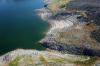
Nice Ramps IMG 0585
| | |
|
Nickens, Dan - Oct 14,2018
Viewers
| Reply
|
| |
See! Nobody on the island at all! Probably thick with poison ivy. It must suck to be down there.
Blue Mesa Reservoir, CO 9/22
| | Attachments:
Restricted Access IMG 0593
| | |
|
Nickens, Dan - Oct 14,2018
Viewers
| Reply
|
| |
Must be full of stinking muck covered by a thin veneer of pretty. Forget the ban. I wouldn't want to be stupid enough to get suckered into such a quagmire.
Blue Mesa Reservoir, CO 9/22
| | Attachments:

Full of Muck IMG 0596
| | |
|
Nickens, Dan - Oct 14,2018
Viewers
| Reply
|
| |
Such a disgusting sight. I had to get down low to confirm it, but see the white suds? Probably detergent from a park ranger's dirty laundry.
Blue Mesa Reservoir, CO 9/22
| | Attachments:
Disgusting Sight IMG 0600
| | |
|
Nickens, Dan - Oct 14,2018
Viewers
| Reply
|
Nickens, Dan - Oct 14,2018
Viewers
| Reply
|
| |
So, if the water is off limits, why did they put a nice runway right beside it?
Blue Mesa Reservoir, CO 9/22
| | Attachments:

Lakeside Runways IMG 0602
| | |
|
Nickens, Dan - Oct 14,2018
Viewers
| Reply
|
| |
What, they can't even make a straight runway? Of course the 'crats were probably drunk when they laid it out. Oh, wait. It's Colorado. They were probably high on weed.
Blue Mesa Reservoir, CO 9/22
| | Attachments:

Bad Alignment IMG 0604
| | |
|
Nickens, Dan - Oct 14,2018
Viewers
| Reply
|
| |
What happened to the 'crats work here? Run out of money for concrete bulkheads?
Blue Mesa Reservoir, CO 9/22
| | Attachments:
Nothing Straight IMG 0614
| | |
|
Nickens, Dan - Oct 14,2018
Viewers
| Reply
|
| |
Next year's budget will undoubtedly include removal of the unsightly pile of rocks.
Blue Mesa Reservoir, CO 9/22
| | Attachments:
Rock Dump IMG 0621
| | |
|
Nickens, Dan - Oct 14,2018
Viewers
| Reply
|
| |
What! No postings? "Warning. Off Limits to SeaReys (And Anyone Else Doing Something a Little Different.)"
Blue Mesa Reservoir, CO 9/22
| | Attachments:
No Postings IMG 0624
| | |
|
Nickens, Dan - Oct 14,2018
Viewers
| Reply
|
| |
So, it's open season for habitat-destroying Big Boy Toys, but not for eco-friendly SeaReys?
Blue Mesa Reservoir, CO 9/22
| | Attachments:
Open Season IMG 0629
| | |
|
Nickens, Dan - Oct 14,2018
Viewers
| Reply
|
| |
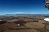
My vituperous harangue regarding the seaplane blockade quieted when the river shrank to a pretty (and unnavigable) stream.
Gunnison River near Gunnison, CO 9/22
| | Attachments:
Quiet Place IMG 0631
| | |
|
Nickens, Dan - Oct 14,2018
Viewers
| Reply
|
| |
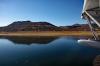
There was one last high mountain pass to cross in the morning flight plan. You know it's a good day when the 10000' pass looks so nice!
Cochetopa Pass, West of Saguache, CO 9/22
| | Attachments:
Pretty Pass IMG 0657
| | |
|
Nickens, Dan - Oct 14,2018
Viewers
| Reply
|
| |
The yellow cautionary signals were subdued against the clear green signals promising an easy crossing.
Cochetopa Pass, West of Saguache, CO 9/22
| | Attachments:

Mixed Signals IMG 0663
| | |
|
Nickens, Dan - Oct 14,2018
Viewers
| Reply
|
| |
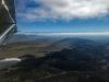
Open territory for stress free crossing of the great Rockies.
West of Saguache, CO 9/22
| | Attachments:

Smooth Crossing IMG 0673
| | |
|
Nickens, Dan - Oct 14,2018
Viewers
| Reply
|
| |
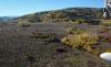
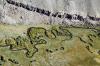
The pass wasn't all rocky. There was a bright little stream going my way.
West of Saguache, CO 9/22
| | Attachments:
Bright Water IMG 0675
| | |
|
Nickens, Dan - Oct 14,2018
Viewers
| Reply
|
| |
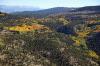
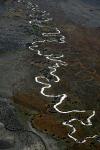
The little stream wandered all over the gentle mountain valley.
West of Saguache, CO 9/22
| | Attachments:
Wandering Way IMG 0678
| | |
|
Nickens, Dan - Oct 14,2018
Viewers
| Reply
|
| |
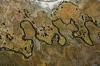
There were boundaries, however, to its easy wandering ways.
West of Saguache, CO 9/22
| | Attachments:
Hard Stop IMG 0688
| | |
|
Nickens, Dan - Oct 14,2018
Viewers
| Reply
|
| |
Clouds? Mountain Obscuration? Valley Obscuration too?
Oh, no! Not another tricky day!
Oh, sure, the weather prognostication included warning of low weather east of the Rockies. I did not recall, however, seeing anything about low clouds in the high valley.
Well, whether mentioned or not, the weather was there. Now I just needed to figure out how to avoid the unexpected white flight barrier.
West of Saguache, CO 9/22
| | Attachments:
Low Barrier IMG 3287
| | |
|
Nickens, Dan - Oct 14,2018
Viewers
| Reply
|
| |
The problem got closer. Perhaps I could duck under the white blanket? Flying around it over the spine of the Rockies was not an appetizing option.
West of Saguache, CO 9/22
| | Attachments:
Closing In IMG 0699
| | |
|
Nickens, Dan - Oct 14,2018
Viewers
| Reply
|
| |
As if the ocean parted for the little SeaRey, the skies opened up over the valley.
North of Monte Vista, CO 9/22
| | Attachments:
Open Valley IMG 0713
| | |
|
Nickens, Dan - Oct 14,2018
Viewers
| Reply
|
Nickens, Dan - Oct 14,2018
Viewers
| Reply
|
| |
With all obstacles overcome or bypassed, there was a clear and easy approach into the Monte Vista airport (KMVI). It was 2.8 mostly excellent flight hours, covering only 170 miles horizontally, but a lot more vertically. It was all downhill now.
Monte Vista, CO 9/22
| | Attachments:
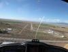
Clear Approach IMG 0715
| |
| Attachments:
Day 3 Run (1)
| | |
|
David Geers - Oct 15,2018
Viewers
| Reply
|
| |
Fantastic photos Dan thanks for sharing.
| | |
|
Don Maxwell - Oct 16,2018
Viewers
| Reply
|
| |
I'm glad the 'crats didn't notice you, Dan. Just knowing they've been there ahead of me usually turns my sky grey. Grey must be the color of bureaucracy. Even gray, with an a, seems to have an intimation of sunshine. Show your true colors, you 'crats! (Yes, yes, I know: bureaucracy keeps the trains running on time, the lights on, etc., etc.)
| | |
|
Nickens, Dan - Oct 16,2018
Viewers
| Reply
|
| |
The 'crats do cast a pall, Don, even when the train is on time. Having a snitch in the cockpit didn't help. This airplane had ADS-B installed. It was a definite distraction, as I kept looking for the Reply signal indicating I'd been pinged. Fortunately it wasn't receiving behind the walls of granite. Anyone who thinks we won't be tracked isn't sufficiently paranoid (and it's not paranoid if you ARE being followed!).
| | |
|
Eric Batterman - Oct 16,2018
Viewers
| Reply
|
| |
Best you get that faulty transponder circuit breaker looked at soon.
| | |
|
Don Maxwell - Oct 18,2018
Viewers
| Reply
|
| |
I suppose a faulty transponder circuit breaker could be a disadvantage if one were to get lost way out in the boonies, with no other position locator aboard to get help if it were needed. On the other hand, a breaker fault might go unnoticed out in the boonies and low, especially if one were to make a precautionary landing on a body of water or a pit stop on a public road. Technology is fickle: there may be an epidemic of faulty circuit breakers.
| | |
|
Nickens, Dan - Oct 16,2018
Viewers
| Reply
|
| |
Well, there are intermittent electrical issues with the airplane, Eric, likely associated wilth the saltwater baths I subjected it to. 😜
| | |
|
|
|
|
|
|
|
|
|
|
|
| |
- About Searey.us -
- Contact Searey.us -
|
- Privacy Statement -
- Terms of service -
|
Copyright © 2024 Searey.us & Brevard Web Pro, Inc. -
Copyrights may also be reserved
by posters and used by license on this site. See Terms of Service for more information.
|
| |
- Please visit our NEW
Chapter Place Website at: chapterplace.com or
Free Chapter Management Website at: ourchapter.org. Good for all chapters, groups or families. |
| | | | | | | | | | | | | | | | | | | | | | | | | | | | | | | | | | | | | | | | | | |