|
|
 |
|
|
|
|
|
|
|
|
Posted By:
Nickens, Dan
Date Posted:
Oct 12, 2018
Description:
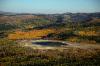
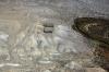
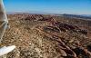
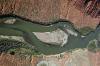
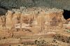
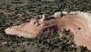
In 1942 the Tooele Army Depot was situated in a remote, inaccessible part of the interior. The Army set up an ammunition storage and testing area on 23,000 acres of desert. It was such a great location for operating out of sight, the government added to its facilities with the Deseret Chemical Depot and Test Center, and the Dugway Proving Ground. Lots of secret activities involving nasty bombs and chemicals took place.
Then highways and airplanes let civilians get around entirely too easily and they began encroaching on the secret, dangerous places. Eventually President Nixon decided to renounce chemical and biological weapons, throwing many billions of dollars to clean up the now not so remote outposts.
It brought unwanted attention to previously unnoticed activities. Even though the Tooele Army Depot's mission is now entirely conventional, skeptics are not convinced they are innocuous. New neighbors believe they have seen things, alien things. The local newspaper has quoted the local president of Utah UFO Hunters as saying UFO have been sighted and are stored in and around the facilities. He believes that the area is now the New Area 51, and likely a military spaceport too.
It all looked quiet when I flew over, but appearances can be deceiving. With my contacts all long retired now, I didn't bother to stop and ask about the alien eggs I spotted out on the lake. I was operating with a schedule, pushed by weather and my mission of getting SuRi's (not-so-)old SeaRey to its new owner.
Date Taken:
September 21, 2018
Place Taken:
Tooele Army Depot, UT
Owner:
Nickens, Dan
File Name:
- Photo HTML
Full size - <img src="/show.php?splash=7OKnyOgxzh">
Medium - <img src="/show.php?splash=7OKnyOgxzm">
Thumbnail - <img src="/show.php?splash=7OKnyOgxzs">
Category:
Cross Country Reunion
|
|
|
 Favorite option: If you want this item to be marked as a favorite, click on the black heart.
Remote Outpost (Reunion Flight Day 2 Part 3)
Favorite option: If you want this item to be marked as a favorite, click on the black heart.
Remote Outpost (Reunion Flight Day 2 Part 3) |
|
Make Cover Photo
Clear Cover Photo
|
|

Click on photo to view the original size. |
| Viewers
|
|
|
|
|
|
|
|
|
|
|
Read what others had to say:
|
|
|
|
|
|
|
 |
Nickens, Dan - Oct 11,2018
Viewers
| Reply
|
| |
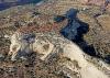
A military yard sale? There were several cool old trucks and a bunch of pressure vessels. It might be worth the risk of contamination to get a truck, but no way you could give me one of the vessels. (I hope it's not a yard sale and not a scrap yard. It would be a shame to see the old pickup trucks crushed, even if they are a little hot.)
Tooele Army Depot, UT
| | Attachments:
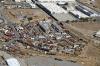
Yard Sale IMG 0073
| | |
|
Nickens, Dan - Oct 11,2018
Viewers
| Reply
|
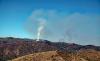
| |
Uh, oh. Mountains obscured in fire and smoke. That, and an associated TFR, mandated a change of routing plans. I could deviate south and just keep going, or I could slip a bit south around the fires then continue southwest. Doing the later meant going over mountains where there was no pass. Going south meant flying over and through a lot of desert. I really didn't want to miss the Green River and Colorado, but I'd just have to see how much a deviant I had to become before deciding.
West of Provo, UT
| | Attachments:
Mountain Obscuration IMG 0076
| | |
|
Nickens, Dan - Oct 11,2018
Viewers
| Reply
|
| |
Even though the pass was covered with smoke, south looked passable. There was no named pass, just a low 9,777' hill to climb. In an area of peaks over 11,000' that qualifies as passable.
West of Fairview, UT
| | Attachments:
No Pass IMG 0079
| | |
|
Nickens, Dan - Oct 11,2018
Viewers
| Reply
|
| |
Uh, oh (again). Small smoke? It was south of the TFR, but it was sure to be trouble before too long. Too bad I had finished off most of my water, or I could have done some fire bombing. I knew the bilge was dry. I just flew on.
South of Scofield, UT in the Mt. Nebo Wilderness Area
| | Attachments:
Trouble Simmering IMG 0086
| | |
|
Nickens, Dan - Oct 11,2018
Viewers
| Reply
|
| |
Wait! Water! I could land, fill the bilge, and attack the fire.
But was the pond suitable as a SeaRey firebombing resource? It looked a little depleted, judging by the wide uncovered shore. It was also located at 10,000' msl. With the outside temperature up above 70 the density altitude was probably pushing 13,000'. Maybe it was a little short for getting off with a bilge full of water. Well, maybe it's just as well to leave firebombing to the professionals.
West of Fairview, UT
| | Attachments:
Bombing Resource IMG 0089
| | |
|
Nickens, Dan - Oct 11,2018
Viewers
| Reply
|
| |
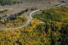
When they weren't burning the trees looked great in their fall colors. Finding the road was nice too.....nice to have a place to go if the engine went bad.
West of Fairview, UT
| | Attachments:
Golden Treess IMG 0093
| | |
|
Nickens, Dan - Oct 11,2018
Viewers
| Reply
|
| |
A scenic mountain retreat looked like a great place to take a break. It was too civilized for me though, so I flew on.
West of Fairview, UT
| | Attachments:
High Campgrounds IMG 0096
| | |
|
Nickens, Dan - Oct 11,2018
Viewers
| Reply
|
| |
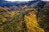
Shimmering in the fall afternoon some of the hills were absolutely golden. I can confirm it: "Thars gold in them thar hills!"
West of Fairview, UT
| | Attachments:
Golden Slopes IMG 0109
| | |
|
Nickens, Dan - Oct 12,2018
Viewers
| Reply
|
| |
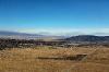
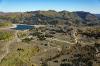
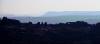
Castle Valley is just an outskirt of the more visited attractions of Moab, UT. It has plenty of fine views, but less tourists. As I left the mountains I stopped to find fuel at Huntington Municipal (69V). That's a mighty fine sounding airport name for a ghostly quiet little strip serving a spot on the road. It had many of the advantages of a big airport, though, with self service fuel, a pilot shack with cold water, and best of all, multiple long runways making it easy to deal with strong, tumultuous winds.
That reminded me about the prior owner's wild tale of flying from Florida to Seattle with a fully castoring tail wheel (due to a broken pin). Without knowing better he assumed the SeaRey was a wicked tail dragger. Fortunately his experience in a Christian Eagle served him well and he succeeded in making the harrowing journey intact.
Near Hiawatha, UT
| | Attachments:
Down to Valley IMG 0114
| | |
|
Nickens, Dan - Oct 11,2018
Viewers
| Reply
|
| |
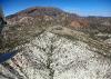
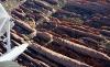
The Green River was on my flight path for a quick crossing. A minor jog, however, would put me along its path for fine flying in its canyon lands. And, there was a way to get into the canyons through the Patmos Mountains via the Price River. I was well ahead of the weather behind me and catching up to weather in Texas, so, let's go!
Near Woodside, UT
| | Attachments:
Into Canyonlands IMG 0128
| | |
|
Nickens, Dan - Oct 11,2018
Viewers
| Reply
|
| |
The entrance to the Price River Canyon looked inviting, almost soft.
Near Woodside, UT
| | Attachments:
Canyonsides IMG 0139
| | |
|
Nickens, Dan - Oct 11,2018
Viewers
| Reply
|
Nickens, Dan - Oct 11,2018
Viewers
| Reply
|
| |
The big river was a nice relief from the rocky landing places along the smaller stream. I shot a short, bad, unedited iphone video with no music other than that of the reassuring monotones of the Rotax engine because I didn't want to wear out my camera's shutter!
Green River North of Green River, UT
| | Attachments:

Canyon Video
| |
| Attachments:
Down River IMG 0171
| | |
|
Don Maxwell - Oct 12,2018
Viewers
| Reply
|
| |
Aw, man, that would test one's determination to make distance that day.
| | |
|
Nickens, Dan - Oct 11,2018
Viewers
| Reply
|
| |
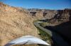
The canyon walls were impressively sheer. Fortunately there was plenty of room between them to maneuver comfortably.
Green River Canyon north of Green River, UT
| | Attachments:
Hardwalls IMG 0179
| | |
|
Nickens, Dan - Oct 11,2018
Viewers
| Reply
|
| |
Sadly, the walls opened up too soon. Sigh.
Green River Canyon north of Green River, UT
| | Attachments:
Opening Out IMG 0184
| | |
|
Nickens, Dan - Oct 11,2018
Viewers
| Reply
|
| |
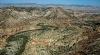
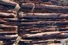
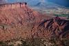
Even though one side was gone, I turned east and kept the big cliffs close by. Classic stratigraphy was on grand display in the Book Cliffs.
Book Cliffs south of Roan Peaks, near Crescent Junction, UT
| | Attachments:
Wrinkled Edge IMG 0201
| | |
|
Nickens, Dan - Oct 11,2018
Viewers
| Reply
|
| |
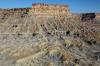
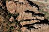
As impressive as the cliffs are, the talus skirting them was just as beautiful.
Book Cliffs south of Roan Peaks, near Crescent Junction, UT
| | Attachments:

Sharp Relief IMG 0203
| | |
|
Nickens, Dan - Oct 11,2018
Viewers
| Reply
|
| |
When flying graphic evidence of the power of gravity is humbling.
Book Cliffs south of Roan Peaks, near Crescent Junction, UT
| | Attachments:
Rocky Skirts IMG 0217
| | |
|
Nickens, Dan - Oct 11,2018
Viewers
| Reply
|
| |
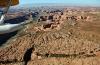
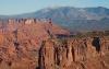
Off to the south of the cliffs I spotted an assortment of geological oddities: Arches National Park. A short deviation would allow me a better view, skirting the park to the north.
North of Moab, Edge of Arches National Park, UT
| | Attachments:
Edge of Arches IMG 0227
| | |
|
Nickens, Dan - Oct 11,2018
Viewers
| Reply
|
Nickens, Dan - Oct 11,2018
Viewers
| Reply
|
| |
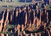
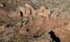
Almost hoodoos! Well, they would be called hoodoos if they were in Bryce Canyon. These are better named earth pyramids. Fairy Chimney just sounds too hokey.
North of Moab, Edge of Arches National Park, UT
| | Attachments:
Rock Rows IMG 0238
| | |
|
Nickens, Dan - Oct 11,2018
Viewers
| Reply
|
| |
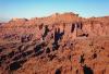
Finely spaced sandstone fins would make for an interesting emergency landing. The gaps were big enough to squeeze the hull into. The wings would float on top holding the plane up, just like a swamped 'Rey. Right.
North of Moab, Edge of Arches National Park, UT
| | Attachments:
Line Break IMG 0263
| | |
|
Nickens, Dan - Oct 11,2018
Viewers
| Reply
|
| |
A perpendicular line through the fins made me turn quickly to see if I could figure out why it was there. Erosion takes advantage of fractures and faults. Most of them were predominantly parallel. This one crossed paths with normality.
North of Moab, Edge of Arches National Park, UT
| | Attachments:
Shape Left IMG 0266
| | |
|
Nickens, Dan - Oct 11,2018
Viewers
| Reply
|
| |
A veritable forest of fairy chimneys. Okay, so I can see the name sticking here.
North of Moab, Edge of Arches National Park, UT
| | Attachments:
More Pointed IMG 0272
| | |
|
Nickens, Dan - Oct 11,2018
Viewers
| Reply
|
| |
A few of the fins were fatter, more rounded. More curvy.
North of Moab, Edge of Arches National Park, UT
| | Attachments:
More Rounded IMG 0275
| | |
|
Nickens, Dan - Oct 11,2018
Viewers
| Reply
|
| |
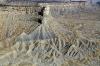
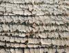
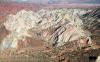
Rocks at higher elevations were covered in white. Not snow. White sandstone. Not yet completely eroded away.
North of Moab, Edge of Arches National Park, UT
| | Attachments:

White Caps IMG 0280
| | |
|
Nickens, Dan - Oct 11,2018
Viewers
| Reply
|
| |
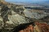
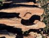
Some of the white sandstone completely covered the red beneath. It was already broken up into blocks that will allow the red fins to grow as erosion continues to do its work. The work is aided and abetted by thick salt beds underlying the Navajo and Entrada Sandstones, pushing them upward and emphasizing their faults.
North of Moab, Edge of Arches National Park, UT
| | Attachments:
Sloppy Pavers IMG 0286
| | |
|
Nickens, Dan - Oct 11,2018
Viewers
| Reply
|
| |
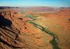
The primary cutting tool of erosion is still hard at work in the Colorado River valley.
Colorado River, Northeast of Moab, UT
| | Attachments:
Cutting Tool IMG 0293
| | |
|
Nickens, Dan - Oct 11,2018
Viewers
| Reply
|
| |
It must be a spectacular swimming pool when the river floods!
Colorado River Valley, Northeast of Moab, UT
| | Attachments:
Eroded Tub IMG 0297
| | |
|
Nickens, Dan - Oct 11,2018
Viewers
| Reply
|
| |
It looked like a great movie set to the south.
Looking South along CO River, Northeast of Moab, UT
| | Attachments:
Distant Peaks IMG 0304
| | |
|
Nickens, Dan - Oct 11,2018
Viewers
| Reply
|
| |
The sun was getting low on the western horizon, bringing out deep color from the old rocks.
CO River Valley, Northeast of Moab, UT
| | Attachments:
Red Relief IMG 0308
| | |
|
Nickens, Dan - Oct 11,2018
Viewers
| Reply
|
| |
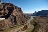
Heading up river towards Grand Junction I could just follow the river.
CO River Valley, Northeast of Moab, UT
| | Attachments:
Going UpRiver IMG 0311
| | |
|
Nickens, Dan - Oct 11,2018
Viewers
| Reply
|
| |
Oh, I was sorely tempted. It was, however, late in the day. My adrenaline was expended. I decided it was prudent to save enough energy to do one more landing at an airport, not in shallow water beneath steep cliffs.
CO River Valley, Northeast of Moab, UT
| | Attachments:
Too Late to Land IMG 0315
| | |
|
Nickens, Dan - Oct 11,2018
Viewers
| Reply
|
| |
There have to be a whole bunch of Hollywood cowboys and Indians somewhere down there!
CO River Valley, Northeast of Moab, UT
| | Attachments:
Classic Western IMG 0317
| | |
|
Nickens, Dan - Oct 11,2018
Viewers
| Reply
|
| |
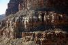
Great pillars are peeling off the walls of the canyon.
CO River Valley, Northeast of Moab, UT
| | Attachments:
Red Wall IMG 0336
| | |
|
Nickens, Dan - Oct 11,2018
Viewers
| Reply
|
| |
Sometimes the colors get all jumbled up. Some geologist probably could explain how it happened. Something about anticlines, synclines, graubens, faults, or maybe fairies.
CO River Valley, Northeast of Moab, UT
| | Attachments:
Spilled White IMG 0340
| | |
|
Nickens, Dan - Oct 11,2018
Viewers
| Reply
|
| |
This would make a fantastic temple with very little work. Or no work at all.
CO River Valley, Northeast of Moab, UT
| | Attachments:

Columnar Side IMG 0349
| | |
|
Nickens, Dan - Oct 11,2018
Viewers
| Reply
|
| |
Now this is a classic hoodoo in the making, with the white hard hat preventing underlying red from eroding. Come back in 10,000 years and you'll see.
CO River Valley, Northeast of Moab, UT
| | Attachments:
Capped Slab IMG 0382
| | |
|
Nickens, Dan - Oct 11,2018
Viewers
| Reply
|
| |
With rising sea level (or river level), this would make one fine waterfront property.
CO River Valley, Northeast of Moab, UT
| | Attachments:
Isthmus in Flood IMG 0405
| | |
|
Nickens, Dan - Oct 11,2018
Viewers
| Reply
|
| |
With the valley getting broader, the scenery was getting slightly more subdued. Subdued in a spectacular kind of way.
CO River Valley, Northeast of Moab, UT
| | Attachments:
Last Point IMG 0417
| | |
|
|
|
|
| |
- About Searey.us -
- Contact Searey.us -
|
- Privacy Statement -
- Terms of service -
|
Copyright © 2024 Searey.us & Brevard Web Pro, Inc. -
Copyrights may also be reserved
by posters and used by license on this site. See Terms of Service for more information.
|
| |
- Please visit our NEW
Chapter Place Website at: chapterplace.com or
Free Chapter Management Website at: ourchapter.org. Good for all chapters, groups or families. |
| | | | | | | | | | | | | | | | | | | | | | | | | | | | | | | | | | | | | | | |