|
|
 |
|
|
|
|
|
|
|
|
Posted By:
Nickens, Dan
Date Posted:
Jul 2, 2018
Description:
"Can you fly this airplane to the AOPA show in Montana? It needs to be there Thursday."
Right. I've heard this story off and on now for months.
"No, seriously. The new owner will let us display it there. It's all set up."
Yeah, it's all set up except that the show starts in four days. The
southern quarter of the country is covered with tropical moisture and thunderstorms, the western part has a slow moving cold front with low IFR weather, and there are some big mountains along the 2,000 mile way.
So, yeah. I'm in.
Date Taken:
June 15, 2018
Place Taken:
Missoula, MT
Owner:
Nickens, Dan
File Name:
- Photo HTML
Full size - <img src="/show.php?splash=7LcTDK7Pah">
Medium - <img src="/show.php?splash=7LcTDK7Pam">
Thumbnail - <img src="/show.php?splash=7LcTDK7Pas">
Category:
SeaRey Shows
|
|
|
|
|

Click on photo to view the original size. |
| Viewers
|
|
|
|
|
|
|
|
|
|
|
Read what others had to say:
|
|
|
|
|
|
|
 |
Nickens, Dan - Jun 29,2018
Viewers
| Reply
|
| |
Of course the way west out of Florida was blocked in the early morning hours on the date of
departure. A big line of storms erupted all along the panhandle and began to spread eastward from Tallahassee. I had to head north, up to central Georgia get around it. At Valdosta I squeezed between control zones and restricted areas.
The storms were growing much faster than their depiction on the ADS-B display. The controller at Moody AFB advised there was lightning within 10 miles of the airport. Looking up from the iPad turned out to be the best way to avoid colliding with the walls of water. "Roger. I can see that."
The mass of storms oozed north too. They hung out off the left wing all the way through Georgia
and Alabama before leaving them on the horizon to land at West Memphis, Arkansas.
Skirting Storms Monday, June 11, Tavares to Tifton to Pell City to West Memphis, AK (overnight)
| | Attachments:
2 Skirting Storms
| | |
|
Nickens, Dan - Jun 29,2018
Viewers
| Reply
|
| |
An early departure was necessary for the schedule. Not too early, though, because scattered rain,
clouds, and some low ceilings were already in the briefing for southern Mo. The clouds did get low,
but not SeaRey low.
There was one time, however, that they bumped up against SeaRey minimums. Figures that it would
all get down to personal minimums at Devils Backbone Wilderness. Fortunately a brief jink to the
north brought back some breathing air (altitude), with a nice improvement heading my way to
northwest.
Somewhere over Kansas it hit me: this was like work! I needed a duty break. Pomona Lake offered
the perfect respite.
Water Break, June 13, 2018
| | Attachments:
3 Water Break
| | |
|
Nickens, Dan - Jun 29,2018
Viewers
| Reply
|
| |
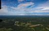
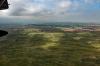
Amazing what a break from the routine can do! Suddenly there was a bright, beautiful world spinning
under the airplane. The Great Plains are, well, GREAT!
| | Attachments:
4 Totos Field
| | |
|
Nickens, Dan - Jun 29,2018
Viewers
| Reply
|
| |
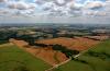
Out among the expansive fields a small corner was set aside for a graveyard. Nothing raises
greater awareness of spiritual matters than a crop of graves.
| | Attachments:
5 Spiritual Revial
| | |
|
Nickens, Dan - Jun 29,2018
Viewers
| Reply
|
| |
Near Blosser there was a railroad bridge...without rails. The steel rails were replaced with wood.
Trains may not come here anymore, but the bridge still lives out a purpose, allowing the rare resident
to cross the river.
| | Attachments:

6 New Purposes
| | |
|
Nickens, Dan - Jun 29,2018
Viewers
| Reply
|
| |
The little water out on the plains might not float a SeaRey. Would the sandbars support one?
Hmmm.....well, play has to be balanced with responsibility. It wasn't my airplane and I was
responsible for getting it to the show. Being stuck on a sandbar in the North Platte River might
jeopardize the balance. (Near Quinn KGTE)
| | Attachments:
7 Too Shallow for SeaReys
| | |
|
Nickens, Dan - Jun 29,2018
Viewers
| Reply
|
| |
Need parts for your 1976 Buick? Or 1966 Model 88 Queen Air? There's a junkyard a 15 miles east of
North Platte, Nebraska that might have what you need.
| | Attachments:
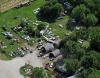
8 Parts is Parts
| | |
|
Ken Leonard - Jun 28,2018
Viewers
| Reply
|
| |
Cool trip Dan. Aerial America has got nothing on the Searey!
| | |
|
Dennis Scearce - Jun 28,2018
Viewers
| Reply
|
| |
Thanks for another adventure, Dan. Do you "have to" hang around to fly it back?
| | |
|
Nickens, Dan - Jun 28,2018
Viewers
| Reply
|
| |
This is already over but the tale hasn't been all told yet, Dennis. Standby.
| | |
|
Dennis Scearce - Jun 28,2018
Viewers
| Reply
|
| |
I'm on the edge of my seat!!
| | |
|
Nickens, Dan - Jun 30,2018
Viewers
| Reply
|
| |
In theory I had punched through the cold front the day before. So what's this behind it: rain
showers, low visibility and ceilings. But that's okay. There looked to be a narrow path to the west.
ADS-B showed scattered airports with marginal ceilings. Those that were too low were close, but not
in line with the magenta line taking me to the show.
As I was flying along the ceiling began to drop. I watched the altimeter shrink lower and the ground
came up. Over my shoulder to the northeast, however, I could see a brighter horizon. That was my
ace-in-the hole. No worries anyway, because I was out over the plains with lots of open space and
no trees.
Trouble was that the plains were no longer flat. They were lumpy. It would make a damage free
landing difficult. Fortunately there were some unpaved roads that looked promising if I got cut off
from my escape.
My brighter horizon faded as I pushed on into the increasing gloom. When I got down to 500' it was
time to do something different. Or not. The airport 30 miles west was reporting 1800' ceiling.
Good, right, except that was not where I was.
Still, if it got really bad, I could set the plane down. Possibly without damage. And there was
nothing, not even cows, out on the great plains.
Possibly without damage? Well, that's not good enough when it's not your airplane. So, what now?
Backtrack? Climb and confess? Try to find the brighter horizon to the northeast?
Oh, wait! The map showed a bunch of little ponds to the north. That's where I could go without
backtracking. And an airport up there was reporting 800', 300+ over what I was in.
Water is reassuring when flying an amphibian. Unfortunately the ponds looked like they could be
really shallow. Who knew, though, because they were the slate-gray color of limestone. At least the
wind was blasting hard enough that it would only take about 10' to land.
The thing is, 500' is not only my limit, it's the FAA's. In the end, that was the deciding factor. When
the altimeter showed me 499' agl, I turned north. After about 3 miles I was back with a 100' margin
over the limit. I inched back towards the west. It got better and better until I found the airport that
was in fact beautiful under a scattered to broken 1800' ceiling.
There was a lot of temptation to duck under. The old animal brain was telling me, what the heck, it's
an open plain! You'd be safely above even the cows at 50' agl. The rational brain said yeah, but if
something went wrong, there would be no good excuse. Limits, if you're going to have them, need
to be real.
| | Attachments:
9 Plain Diversion
| | |
|
Don Maxwell - Jun 29,2018
Viewers
| Reply
|
| |
Now, Dan, this photo--I'm sorry to say it--makes the sky look quite inviting. Or is that what you wanted us to think, as a way of tricking us into flying our armchairs into danger? Here's a companion piece of sorts, taken in the flatland of Virginia. It says, "Don't go there."
| | Attachments:
IMG 4097
| | |
|
Nickens, Dan - Jun 30,2018
Viewers
| Reply
|
| |
No tricks, Don, as the photo was taken after emerging from the dank gray blanket. Before that moment in time I was too
preoccupied to think of the camera.
Your photo clearly says “No Trespassâ€. I’d hope you weren’t tempted.
I remember a bold pilot once telling me that he flew his C210 so low out in Oklahoma that “the gophers had to duck!†He said it was
to avoid a strong headwind. I met him on one of the worst hazardous waste sites EPA ever found. Makes me wonder where he is
now.
| | |
|
Don Maxwell - Jun 30,2018
Viewers
| Reply
|
| |
Oh, I was tempted, Dan. But that time I didn't succumb--because I had succumbed on an earlier occasion and remembered it.
| | |
|
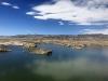
Nickens, Dan - Jun 30,2018
Viewers
| Reply
|
| |
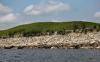
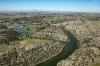
See that nice little beach to the right side of the photo. On the North Platte River just outside the
Gurnesey Control Zone, inside a cold restricted area. Just the perfect place to stretch out the stresses
of the morning.
| | Attachments:
10 Respite Beach
| | |
|
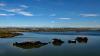
Nickens, Dan - Jun 30,2018
Viewers
| Reply
|
| |
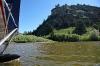
The beach was nicely protected by a shallow bar, with a SeaRey deep entrance from down river. Nice.
| | Attachments:
11 One Bar Over
| | |
|
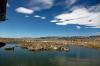
Nickens, Dan - Jun 30,2018
Viewers
| Reply
|
| |
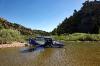
Protected by a sand bar from river currents and by the Army from enemies foreign and domestic.
| | Attachments:
12 Protected Parking
| | |
|
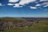
Nickens, Dan - Jun 30,2018
Viewers
| Reply
|
| |
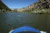
It should have been a quiet, restful place. Instead I could hear the army guys gunning for targets
somewhere over the hill.
Wait! Wasn't the restricted area supposed to be cold? That's what the military controller said. Maybe
no one told the troops. Just in case, the airplane was positioned for launch if the shooting got any
closer.
| | Attachments:

13 Departure Position
| | |
|
Nickens, Dan - Jun 30,2018
Viewers
| Reply
|
| |
With natural sounds getting drowned out by fake war, the beach wasn't perfect. It also wasn't getting
me any closer to Missoula. Back to work. Sigh.
| | Attachments:
14 Back to Work
| | |
|
Nickens, Dan - Jun 29,2018
Viewers
| Reply
|
| |
Pictures not doing it for seeing the big picture? There's a video for that. Too dizzy for my tastes.
| | Attachments:

Going UpRiver
| | |
|
Nickens, Dan - Jun 29,2018
Viewers
| Reply
|
| |
There's also a video for flying back through the canyon. One handed flying while holding the iPhone in
the other hand turned out to be just a bit too much for scooting between the rocks in a windy canyon.
| | Attachments:
Canyon Flying
| | |
|
Nickens, Dan - Jun 30,2018
Viewers
| Reply
|
| |
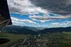
The big climb really got serious after Cody, WY. There was, however, an occasional dip in the road.
| | Attachments:
17 Big Ditch
| | |
|
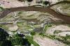
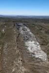
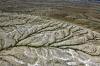
Nickens, Dan - Jun 30,2018
Viewers
| Reply
|
| |
Seriously rumpled ground might help one imagine that there is some pretty extreme geology going on
in these here parts.
| | Attachments:

18 Rumpled Ground
| | |
|
Nickens, Dan - Jun 30,2018
Viewers
| Reply
|
| |
Not much water to work with out this high. Not enough for the SeaRey. Too much for the trains.
| | Attachments:
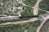
19 Railroad Crossing
| | |
|
Nickens, Dan - Jun 30,2018
Viewers
| Reply
|
| |
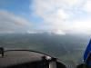
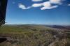
I had to start thinking about finding the best way through and around the mountains. Breaks in the
scenery were a gentle
reminder.
| | Attachments:
20 Mountain Preview
| | |
|
Nickens, Dan - Jun 30,2018
Viewers
| Reply
|
| |
Just when I was deciding which way to wage travel against the big mountain a text from friend
suggested a small diversion would pay big dividends in seen-ery. With no great options because of the
hot midday winds tumbling over the rocks, why not?
| | Attachments:

21 Pathways
| | |
|
Nickens, Dan - Jun 30,2018
Viewers
| Reply
|
| |
The path I had planned was mostly dry. The path suggested by my friend had some big water. That's
a good reason to
change paths.
| | Attachments:
21b Mostly Dry
| | |
|
Nickens, Dan - Jul 01,2018
Viewers
| Reply
|
| |
Winds were gusting up to 25 knots to the east and west of the valley. In the middle on the Boysen Reservoir it was calm to lightly rippled.
| | Attachments:
22 Calm in the Middle
| | |
|
Nickens, Dan - Jul 01,2018
Viewers
| Reply
|
| |
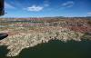
Snowmelt? There was plenty still up there on the high peaks visible on the western horizon.
| | Attachments:
23 Boysen Reservoir
| | |
|
Nickens, Dan - Jun 30,2018
Viewers
| Reply
|
| |
So, if pictures are worth a thousand words, how many a video? The argument is a bit shaky when the video is a handheld iPhone. Anyway, it's an experiment. Since I'm too lazy to edit it, likely not a successful one.
| | Attachments:
Skimming Boysen
| | |
|
Nickens, Dan - Jun 30,2018
Viewers
| Reply
|
| |
Maybe a flying video would be smoother? Or maybe not. The iPhone screen seems to shimmy in the wind. I think I'll leave the video to others. It's way too much work to do it right!
| | Attachments:
Flying Boysen
| | |
|
Nickens, Dan - Jul 01,2018
Viewers
| Reply
|
| |
Blue skies, white clouds, smooth water. A SeaRey kinda place.
| | Attachments:
26 Northern Boysen
| | |
|
Nickens, Dan - Jul 01,2018
Viewers
| Reply
|
| |
How do you get a big pond in a dry place? Dam the river, then let just a trickle out through the canyon.
| | Attachments:
27 Canyon Runs Through
| | |
|
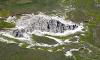
Nickens, Dan - Jul 01,2018
Viewers
| Reply
|
| |
Where the river goes, so goes the road. And rail road. Following the white water line was good enough for the SeaRey too.
| | Attachments:
28 Down Canyon
| | |
|
Nickens, Dan - Jul 01,2018
Viewers
| Reply
|
| |
If the canyon wasn't spectacular enough, the colors around it were great accents.
| | Attachments:
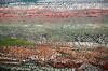
29 Colored Ground
| | |
|
Nickens, Dan - Jul 01,2018
Viewers
| Reply
|
Nickens, Dan - Jul 01,2018
Viewers
| Reply
|
| |
Who says nature doesn't have clear lines of delineation?
| | Attachments:

31 Dividing Lines
| | |
|
Nickens, Dan - Jul 01,2018
Viewers
| Reply
|
Nickens, Dan - Jul 01,2018
Viewers
| Reply
|
| |
A geologist's heaven, where earth has been dissected away to reveal its inner nature.
| | Attachments:

32 Cutaway
| | |
|
Nickens, Dan - Jul 01,2018
Viewers
| Reply
|
| |
A small reservoir offered a minor diversion from a direct path, but there weren't any really pretty beaches, so just a splash and go was all that was justified.
| | Attachments:
33 Water Color
| | |
|
Nickens, Dan - Jul 01,2018
Viewers
| Reply
|
| |
Could this be the Thermopolis, Greek for "Hot City"? It was certainly warm. And there are reported hot springs in the area. I didn't stop, though. I wanted to get to Missoula, but was willing to settle for Helena before dark.
I had been in the air for 10 hours according to the Hobbs meter. I've been known to leave credit cards in Mexican restaurants after very long days of flying. (Oh, no. Nothing to do with margaritas.) Anyway, Ann told me that I had to quit flying long days if I was going to keep losing credit cards. I stopped for the night in Helena to avoid that fate.
| | Attachments:
34 Thermopolis
| | |
|
Nickens, Dan - Jul 01,2018
Viewers
| Reply
|
| |
The forecast warned of mountain obscuration. The radar showed showers in the vicinity. Winds in the mountains were already on the increase under cloudy morning skies. The forecast was for worsening conditions in the afternoon. To make it to the show on time, it was time to have a go at it. Or not. Maybe just a quick look at actual conditions?
| | |
|
Nickens, Dan - Jul 01,2018
Viewers
| Reply
|
| |
Mountain obscuration. Check. But, I'm in the valley. Onward.
| | |
|
Nickens, Dan - Jul 01,2018
Viewers
| Reply
|
| |
Turbulence. Check. Onward.
| | |
|
Nickens, Dan - Jul 01,2018
Viewers
| Reply
|
| |
Between a rock and a hard place. Turn around? Squeeze through? Either way, there are viable options if things get worse. Just a dip towards 500' agl at the peak, then, Onward.
| | |
|
Nickens, Dan - Jul 01,2018
Viewers
| Reply
|
| |
Rain, check. Hopeful Rainbow, counter check. Onward, then.
| | |
|
Nickens, Dan - Jul 01,2018
Viewers
| Reply
|
| |
Finally some blue sky. Definitely onward!
| | |
|
Nickens, Dan - Jul 01,2018
Viewers
| Reply
|
| |
Someone lower? It's not often I get passed by an airplane flying lower than I do. This guy was definitely low IFR ("I Follow Roads" . The road led right to Missoula. And I got there before the show Notams took effect. "Approved for straight in Runway 29." The wind was gusting just a little less than the designated runway, but who cares when it's right down the middle of the runway. After 30 hours in the air, covering 2000 miles of ground at speeds ranging from 50 to 105, the airplane was delivered as requested with nothing more than a bunch of bugs to show for it. . The road led right to Missoula. And I got there before the show Notams took effect. "Approved for straight in Runway 29." The wind was gusting just a little less than the designated runway, but who cares when it's right down the middle of the runway. After 30 hours in the air, covering 2000 miles of ground at speeds ranging from 50 to 105, the airplane was delivered as requested with nothing more than a bunch of bugs to show for it.
| | |
|
Nickens, Dan - Jul 01,2018
Viewers
| Reply
|
| |
Weather for the first day of the show was spectacular. There was lot to learn. For one thing, who knew Hans Solo lives in Missoula!
| | |
|
Nickens, Dan - Jul 01,2018
Viewers
| Reply
|
| |
After the show there was one more chance for flight. I hitched a ride with the new owner, Shawn, to his home airport in Spokane. We took the scenic route along the Flathead River to Lake Pend Oreille, then southwest. The airplane found a new home at Felts Field (KSFF). That's Shawn in the left seat, with his friend and hangar mate Shelton, in the right. Shawn is planning an open house in September. With beautiful scenery, water and grass runways, and a restaurant on the field it will be the place to be for SeaRey friends.
| | |
|
|
|
|
|
|
|
|
|
| |
- About Searey.us -
- Contact Searey.us -
|
- Privacy Statement -
- Terms of service -
|
Copyright © 2024 Searey.us & Brevard Web Pro, Inc. -
Copyrights may also be reserved
by posters and used by license on this site. See Terms of Service for more information.
|
| |
- Please visit our NEW
Chapter Place Website at: chapterplace.com or
Free Chapter Management Website at: ourchapter.org. Good for all chapters, groups or families. |
| | | | | | | | | | | | | | | | | | | | | | | | | | | | | | | | | | | | | | | | | | | | | | | | |