|
|
 |
|
|
|
|
|
|
|
|
|
|
|
 Favorite option: If you want this item to be marked as a favorite, click on the black heart.
The new tappanzee bridge under construction
Favorite option: If you want this item to be marked as a favorite, click on the black heart.
The new tappanzee bridge under construction |
|
Make Cover Photo
Clear Cover Photo
|
|

Click on photo to view the original size. |
| Viewers
|
|
|
|
|
|
|
|
|
|
|
Read what others had to say:
|
|
|
|
|
|
|
 |
Mark MacKinnon - Sep 17,2016
Viewers
| Reply
|
| |
Been over the old one many times. Very doubtful I will ever go over the new one, as I don't go that way anymore when going south. Too many expensive tolls and too much traffic.
| | |
|
Brian Furnell - Sep 19,2016
Viewers
| Reply
|
| |
Forgive the quality of the story, I was a below average student... it may be a though read, buts its
factual at least.
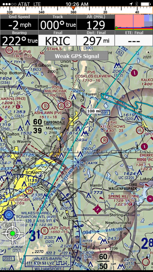
My trip from Republic Airport Long Island to Seaplane Homecoming, Hammondsport NY in the Finger Lakes, well...almost. The night before my trip, weather was reporting VFR with ceilings floating around 3 to 4 thousand at time of departure (7am) with showers and thunderstorms approaching from the west later in the evening. Surface wind at destination forecasted at 15 gusting 22knots, this concerned me and was the first time I considered not going. Got to bed early and woke up as fresh as you can be at 5:30am and checked weather. After an hour of back and forth of go or no go, I decided it didn*t look great but was going to be VFR all the way, and the winds weren*t as bad as forecasted, so I head to the airport. Wheels were up at about 8:00, a full 1hr after my intended departure time but it was smooth air and good visibility for the first hour of flying, so far so good. Following the Delaware River was comforting because I felt like I always had a landing spot, was I wrong!! There is whitewater in that river!! No worries, some fields, roads, and lakes large enough to save my bacon if it got ugly, did I mention most of this flight would be over mostly uninhabited forest. I begin to see gloomy skies off in the distance, I*m at 3000msl/1500agl ft. skimming the bottom of a 3200ft ceiling and doing my best to keep up on listening to weather at nearby airports. Some of them are reporting scattered 1200, yea I see those, plenty of huge holes below me, and manageable winds, I fly on. Here is where things start to get interesting, I am approaching Scranton PA, well.. 20 miles to the north east and there is a ridge line that I will need to cross in order to get to much better weather on the other side. At least that is what the IPhone weather was telling me, and I couldn*t get an update on the radio, just wasn*t high or close enough to a reporting airport to receive. As I approach the ridge, forward visibility is getting worse, and I started to feel like I was flying into IMC so I start to make an about face. During the turn I also descend a little, and visibility improves greatly. Lets have another look at this ridge, ok..looks manageable because there is a small pass that I should be able to get through. Now the reality check.. I*m now at 2500ft, scattered at 1200 and thickening, winds are out of the south at over 20knots, and the Iphone/Ipad are lit up screaming...terrain, terrain. This ridge is lined with Searey pulverizing devices (wind farm) and there are so many antennas, this mountain is starting to look more like a porcupine. Not 100% sure I can see all the way through this pass was the nail in the coffin. Its time!! I*m done with this abuse. ABOUT FACE!! Time and fuel check... I can make it back non stop and still be drinking a beer with lunch. Geeze, weather is getting worse all around me, not having much fun at this point. By the time I get to the Hudson River weather clears up but I am still getting bumped around, only 35 more minutes of this crap, hooray. I finally reach long island sound and see a sailing race starting to get underway, except for the fact there is no wind. This is good for me, finally things starting to go my way. Get the atis back at home base and there reporting 2500 broken, wind 10@190, runway 19. I get cleared to land for a straight in and make one of the smoothest I have ever made. As I am doing my post flight the field is going in/out MVFR and it looks to be getting worse. I continued to look at the weather for the rest of the day, and turning around when I did was the best decision I could have made because I think I would still be stuck in Hammondsport if I did make it. My mother was glad, I was able to make her 70th birthday yesterday. Wife was glad, because she didn*t have to go without me. And I*m glad, to be breathing air.
IMG_1043
| | |
|
Philip Mendelson - Sep 20,2016
Viewers
| Reply
|
| |
Good job! Been there many times!
| | |
|
Carr, Frank - Sep 19,2016
Viewers
| Reply
|
| |
Story is good Brian, decision-making better, ending perfect.
| | |
|
Nickens, Dan - Sep 19,2016
Viewers
| Reply
|
| |
I just love happy endings! That's some mighty fine piloting, Brian.
| | |
|
Don Maxwell - Sep 19,2016
Viewers
| Reply
|
| |
Good story, Brian, and a happy ending. The terrain gets really interesting just past where you turned around, so it's good you turned around where you did. For your next trip to Hammondsport, just southeast of your 180 is a big lake, Wallenpaupak, (technically closed to seaplanes now) where I once had to declare an emergency, but not for weather. And there's a Searey based nearby.
| | |
|
Chuck Cavanaugh - Sep 19,2016
Viewers
| Reply
|
| |
BT,DT. Good job.
| | |
|
Mark MacKinnon - Sep 19,2016
Viewers
| Reply
|
| |
Those wind generators are popping up everywhere up here. Hardly a ridgeline that doesn't have them.
Seen many of these huge blades being transported on the roads, an interesting sight.
They are killing birds and bats, and I'm sure they would love to eat a nice crunchy Searey.
| | |
|
Randy Williams - Sep 20,2016
Viewers
| Reply
|
| |
WE have some in Texas.
Now these are huge blades - lots of them - https://drive.google.com/open?id=0BwAx65ooa8SbRWprYzVlS0dSb1U
| | |
|
Don Maxwell - Sep 20,2016
Viewers
| Reply
|
| |
An unnamed Canadian took me flying in his Searey among some turbines a few years ago, after a couple of landings on Lake Erie: https://youtu.be/wxR044LmOHo
| | |
|
Ken Leonard - Sep 21,2016
Viewers
| Reply
|
| |
Good call. Made some of those calls myself and failed to make a couple in a timely way and regretted it.
| | |
|
Brian Furnell - Sep 17,2018
Viewers
| Reply
|
Don Maxwell - Sep 17,2018
Viewers
| Reply
|
| |
Out with the old!
I'm sorry to see that the Peekskill SPB at Cortland, a few miles north of the bridge, is no longer on the chart and looks dead and gone in the GoogleMaps satellite view.
41°14'52.2"N 73°57'37.2"W
41.247827, -73.960337
| | Attachments:

Dead SPB
| | |
|
|
|
|
|
|
|
|
|
|
|
| |
- About Searey.us -
- Contact Searey.us -
|
- Privacy Statement -
- Terms of service -
|
Copyright © 2024 Searey.us & Brevard Web Pro, Inc. -
Copyrights may also be reserved
by posters and used by license on this site. See Terms of Service for more information.
|
| |
- Please visit our NEW
Chapter Place Website at: chapterplace.com or
Free Chapter Management Website at: ourchapter.org. Good for all chapters, groups or families. |
| | | | | | | | |