|
|
 |
|
|
|
|
|
|
|
|
Posted By:
Nickens, Dan
Date Posted:
Jan 8, 2016
Description:
How is it that another SeaRey cross-continent trip is greeted with shrugging ambivalence? Had making dozens of crossings converted the extraordinary to merely mundane? Or was it because of mixed feelings about delivering the yacht's old (but rehabilitated) SeaRey to its new home and new pilot?
Whatever. There was no time for such reflective musings. The airplane had to be moved. It was behind schedule and over budget. Relocation from Florida to California was a task to be completed, not for fun.
Take my camera? Why? Been there done that seen it and have millions of pictures to show for it.
Still, you never know what new might show up even in a routine job. So, I packed the heavy camera. ""It will be good exercise just carrying it.""
Okay, so I was on the clock. Even a factory worker gets an occasional break. Maybe just a quick stop. And, this break was particularly photogenic, so......maybe just a quick shot or two.
Date Taken:
July 10, 2015
Place Taken:
Chocktow River near McIntosh, Alabama
Owner:
Nickens, Dan
File Name:
Quick Break 4811.jpg - Photo HTML
Full size - <img src="/show.php?splash=6xv529ug9h">
Medium - <img src="/show.php?splash=6xv529ug9m">
Thumbnail - <img src="/show.php?splash=6xv529ug9s">
Category:
Yacht_Tending_USA
|
|
|
|
|

Click on photo to view the original size. |
| Viewers
|
|
|
|
|
|
|
|
|
|
|
Read what others had to say:
|
|
|
|
|
|
|
 |
Nickens, Dan - Jan 08,2016
Viewers
| Reply
|
| |
Some might think it an omen. I think it is definitely a sign of wonderment about the world. Oh, what the heck. Take a picture and send it to a friend who might appreciate the possible coincidences. It was not much of a delay or distraction. (Choctow River near McIntosh, AL)

Possible Omen
| | |
|
Nickens, Dan - Jan 08,2016
Viewers
| Reply
|
| |
Even a focused work environment provides for the occasional break from the effort. So what if it was early in the day. The Mississippi River was just too colorful to pass up. (Mississippi River near Port Gibson, Mississippi)

Mississippi Idling
| | |
|
Robert Loneragan - Jan 04,2016
Viewers
| Reply
|
| |
I bet ""that"" person would have really appreciated that feather photo. Funny, after your last visit to Rylstone for about a month my
hangar was full of beautiful feathers but that has died away now. I think it is time you came back to see if we can garner more hangar
feathers.
| | |
|
Nickens, Dan - Jan 08,2016
Viewers
| Reply
|
| |
The Mississippi River wasn't the only colorful river to cross. The aptly named Red River was particularly bright in the summertime sunshine. (Red River near Wichita Falls, Texas)

Painted Sand
| | |
|
Don Maxwell - Jan 08,2016
Viewers
| Reply
|
| |
Red, indeed!
| | |
|
Nickens, Dan - Jan 08,2016
Viewers
| Reply
|
| |
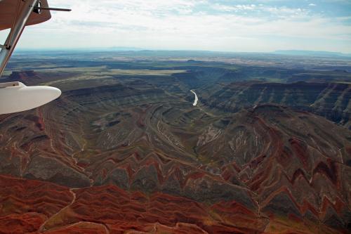
On the edge of the great plateau you can see the land crumbling under the relentless force of gravity. It looked like it was bleeding red. (Near Memphis, Texas)

Crumbling Edge
| | |
|
Nickens, Dan - Jan 08,2016
Viewers
| Reply
|
| |
Is the contrast between man-manicured farms and the wild ever so clearly seen as on the edge of the great plateau? (East of Amarillo, Texas)
Point of Man
| | |
|
Nickens, Dan - Jan 08,2016
Viewers
| Reply
|
| |
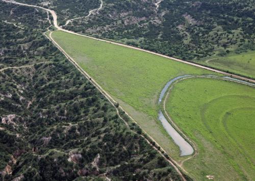
Out on the plateau there is little room frivolous greenery. Untamed green just tends to encircle water unless it is constantly beat back. (East of Amarillo, Texas)

High Oasis
| | |
|
Nickens, Dan - Jan 08,2016
Viewers
| Reply
|
| |
The plateau is so expansive it takes an above ground view to see how it fits spectacularly into a wide western vista. Down-close high views are the rare opportunities commonly available to SeaRey pilots, even if they don't always appreciate the privilege.
Okay, so the camera did come out of its case....on special occasion. Crossing half a continent and only capturing eight shareable shots is some kind of record low for me. (East of Amarillo, Texas)

Crossing Edges
| | |
|
Carr, Frank - Dec 20,2015
Viewers
| Reply
|
| |
Your 'quick shots or two' are alway welcome and informative Dan. Safe trip (or are you back already?).
| | |
|
Nickens, Dan - Dec 20,2015
Viewers
| Reply
|
| |
Back and gone again, Frank. Safe and unsound as always.
| | |
|
Bob Samson - Dec 20,2015
Viewers
| Reply
|
| |
Shame we didn't know your schedule for crossing Texas. We'd of sent out a chase Searey or two or three. Isn't that right y'all?
| | |
|
Nickens, Dan - Dec 20,2015
Viewers
| Reply
|
| |
It was a mission, Bob, with a deadline already well into Hades. Some day, though, it would be delightful to have a SeaRey convoy across the Great State of Texas.
| | |
|
Don Maxwell - Dec 20,2015
Viewers
| Reply
|
| |
Dan, was your fair omen from a fowl? I don't recall seeing that pattern before.
| | |
|
Nickens, Dan - Dec 20,2015
Viewers
| Reply
|
| |
Now, Don, you'll have to judge for yourself if the omen was fair or fowl as the story plays out.....it's a long one so don't expect any quick answers!
| | |
|
Dennis Scearce - Dec 20,2015
Viewers
| Reply
|
| |
I'd been missing your adventures, Dan. Glad you are back at it. Some of your camera shots are real keepers.
| | |
|
Robert Richardson IV - Dec 20,2015
Viewers
| Reply
|
| |
Remember what maybe mundane and old hat to you is exciting to read about to us who are not free to make the flights
that you have. We get to live the adventure through your postings and pictures. Please don't stop! And do thank your
billionaire benefactor for funding your (and our) flying adventures.
| | |
|
Nickens, Dan - Dec 21,2015
Viewers
| Reply
|
| |
I do make a point of thanking him often, Robert. I try not to forget that even the worst SeaRey flying day is still an amazing fortune.
| | |
|
Nickens, Dan - Jan 08,2016
Viewers
| Reply
|
| |
Missile launch? (Conchas Lake Airport, E89, New Mexico)

MISSILE LAUNCH!
| | |
|
Nickens, Dan - Dec 21,2015
Viewers
| Reply
|
| |
After a quick pit stop at the deserted Conchas Lake airport I turned west onto the runway for departure. A flash of light seared into my eyes making me blink and wish for my sunglasses that had fallen into the bilge. When I reopened one eye I saw a smoke trail rising up to where I''d seen the blinding flash.
"Duck and Cover! Duck and Cover!" What had been a silly grade school exercise suddenly seemed a deadly serious nightmare.
A nuclear flash? I squinted to where the vapor trail ended but anything there was invisible in the sun''s glare. A nuclear flare would have left some evidence, right? But what if it wasn''t a nuclear explosion? What if it were a missile intercept? Los Alamos was in a direct line from where the rising trail originated. Was there a missile defense system at Los Alamos? Would we know if there were?
Okay, so if there was a defensive missile launch, some serious crap had hit the fan! Now what? No way I''m going to continue west towards the launch site! Duck and cover? No way. I''ve got a SeaRey. I''m flying and skeedattling. Exiting stage left right now! I jammed the throttle to the limits and held it hard to the metal.
As soon as the wheels cleared the ground I sharply banked 180 degrees away. Away to where? Back to Amarillo? No way. I had to avoid cities.
Not north. Denver was that way and the fallout from the city would be blowing west.
Going east I had a tail wind. Being faster than the wind I was riding on would keep any airborne radiation particles behind me. The gamma rays had already come and gone, so no use crying about that.
What about south? Yeah, maybe that would be best. Head to Mexico. I''d have to pass downwind of Albuquerque. Would Albuquerque be a target? Probably not unless a lot a missiles had launched. The White Sands test range? Maybe, but maybe not.
Mexico sounded good because who would waste nukes on Mexico. I''d take my chances there. I turned south.
What about fuel? I didn''t have enough. I''d have to find some. At some small airport. Somewhere that wouldn''t have a control tower or airport police.
How to pay? Credit cards probably went out with the first atomic explosion. It''d have to be cash. If I landed soon maybe the FBO operator wouldn''t know that money was no good anymore. If anyone was even at FBOs now. Worst case is that I could just siphon gas from other planes or cars. Exigent circumstances make theft morally excusable. ? ! % >
Maybe a lot of other folks would be trying to get out by plane. Or maybe they would just be hunkering down at home. If they're smart they're staying home and don't need the gas, right?
Home? I urgently needed to get home. South wasn''t homeward. That''s okay. A circular bypass of the Caribbean would likely be the best shot at getting around a bombed out North America. It was a real long shot, but it was the best I could think of in all the raging madness of the end of the world.
Daring to look westward again all I saw was a benignly blazing sun under an expansive western blue sky.
What irony to have the ultimate ugliness on such a beautiful day!
Um, there are contrails up there in the big blue. Bombers?
Er, or maybe just commercial stuff?
The commercial flights should all be diverting and heading for the ground.
There! On the horizon! Another missile rising!
Ummm...slowly rising. Really slow.
That''s no missile. It''s just another contrail.
Like the one seen before running scared?
Maybe, but what about the flash? There was a bright flash.
A bright light like suddenly looking up into the sun without sunglasses.
Uh, no. Not like that. It was so sudden and flashy.
Like suddenly looking up into the sun from the dark bilge where the sunglasses had just disappeared?
Um, maybe. No nuclear holocaust?
No, just the usual natural nuclear fireball that circles over our heads every other non-apocalyptic day.
Fine. Okay. Never mind. Back on course.
| | |
|
Carr, Frank - Dec 21,2015
Viewers
| Reply
|
| |
Dan, It's been a while since we have been treated to a 'tale"" or in this case, perhaps not.
You reminded me of the book ""One Second After"". A downer if ever there was one, but plausible and something to think about.
| | |
|
Robert Richardson IV - Dec 21,2015
Viewers
| Reply
|
| |
As a former MMIII triggerman for nuclear Armageddon, I liked your flight back to the scary 1960-70s post nuclear world end.
Something only a baby boomer can really appreciate. None of that milk toast Terrorist threat"" stuff of today. Having seen MIII
launch your photo look just such a launch.
| | |
|
Nickens, Dan - Dec 21,2015
Viewers
| Reply
|
| |
That book was frightening, Frank. Even mainstream news guys are now writing about EMP (see Ted Koppel's book "Lights Out" . But what fun is an apocalypse without an airplane? Have you read "The Dog Stars" by Peter Heller? After a flu pandemic the protagonist lives in hangar with his dog and his C182. If the world is ending, I think it would be transcendent to see it from above with your best buddy. . But what fun is an apocalypse without an airplane? Have you read "The Dog Stars" by Peter Heller? After a flu pandemic the protagonist lives in hangar with his dog and his C182. If the world is ending, I think it would be transcendent to see it from above with your best buddy.
| | |
|
Carr, Frank - Dec 21,2015
Viewers
| Reply
|
| |
I'll have to look up ""Dog Stars"" Dan, but your summary of the plot reminds me of the recent TV series ""The Last Ship"".
The problem with an airburst EMP is that it's too damn plausible.
| | |
|
Dennis Scearce - Dec 21,2015
Viewers
| Reply
|
| |
That's the first time I've ever seen ""skeedattling"" spelled out...
| | |
|
Nickens, Dan - Dec 21,2015
Viewers
| Reply
|
| |
I've never seen it in writing either, Dennis, and I may have misspelled and misused the word. When I was a boy "skeedattling" was hurrying up to have fun. Mostly. I've also heard, "Y'all skeedattle outta here!" when being shooed urgently out of the adult's world.
Checking an "authoritative" Internet source, Your Dictionary, under "Redneck Slang Words", this is what I found: "skedaddle: to leave hurriedly".
| | Attachments:

Redneck Dictionary
| | |
|
Dennis Scearce - Dec 21,2015
Viewers
| Reply
|
| |
Well, my dirt farmer grandparents from Bachelors Hall, VA, didn't know anything about red necks. 'Cause everyone in the community used Red Neck slang and I still do. Wel-li-be.
| | |
|
Nickens, Dan - Jan 08,2016
Viewers
| Reply
|
| |
Alien in appearance, but mundane in purpose. A fine target for SeaRey over-flight even if it was slightly diverting from the straight flight plan path. (East of Las Vegas, New Mexico)

Crop Circle
| | |
|
Nickens, Dan - Jan 08,2016
Viewers
| Reply
|
| |
The life blood of a dry land with the color of a living thing. It's intricate movements, sandy skin, and promise of safe haven for seaplanes in distress make running water irresistible.
Yeah, safety. Flight safety. And protection of flight assets. So it really is prudent to deviate for rivers. That's all I'm saying.
(East of Los Alamos, New Mexico)

Blood Line
| | |
|
Nickens, Dan - Jan 08,2016
Viewers
| Reply
|
| |
Nap of the earth is fine flying when it is a choice. It gets less comfortable when clouds start closing in on higher options. They are a definite reason to change a direct course into a more circuitous one. (West of Espanola, New Mexico)

Squeezing Through
| | |
|
Nickens, Dan - Jan 08,2016
Viewers
| Reply
|
| |
Black clouds rising from a placid plateau may not signal a volcanic eruption (or nuclear fallout), but they inspire caution in flight. (They do not, however, inspire another crazy disaster tale.)
(West of Abiquiu, New Mexico)

Plateau Eruption
| | |
|
Nickens, Dan - Jan 08,2016
Viewers
| Reply
|
| |
Is it the thin air up high that brightens the earth's colors? It's the thin air that makes splashing problematic. Problematic is not a barrier, however, to the fantastically optimistic and seriously seaplane afflicted flyer with a maddening desire to wet his hull.
No barrier but it was another excuse to pull the camera out of its case.
(Abiquiu Reservoir, New Mexico)

High Water
| | |
|
Robert Richardson IV - Dec 21,2015
Viewers
| Reply
|
| |
Is there an altitude limit to splash&goes?
| | |
|
Nickens, Dan - Dec 31,2015
Viewers
| Reply
|
| |
Um, it depends? Practically or legally? You can find an unconfirmed report of a SeaRey splash and go at Turquoise Lake (elevation 11,925'' near Leadville, CO somewhere in the archives. It was the summer and as I recall the density altitude was significantly higher. The reporter (who chooses to remain nameless) refuses to provide authentication data (photographic evidence in his possession) because the lake is in Colorado and not legally open to seaplanes and the statute of limitations hasn''t run. Oh, sure you drive your 500 hp Mercruiser across the water at full throttle, but a seaplane, no way. Is that justice? NO! But it may be proof that the law is an ass. And that''s all I''m saying about that. Rant over.
| | |
|
Nickens, Dan - Dec 21,2015
Viewers
| Reply
|
| |
Defensive cameraman's note: Images inserted with text seem kind of fuzzy here. They really are just large thumbnails. Clicking on a picture, however, brings up a sharper image (if that's of interest to anyone other than the cameraman's chief critic).
| | |
|
Don Maxwell - Dec 21,2015
Viewers
| Reply
|
| |
MUCH sharper! And larger, too. Not quite large enough to tell what the white object in the bulls eye is, but large enough to see that the green landscape with the two slumped areas (4th from top) is really interesting and for a moment made me think of a ruined pueblo.
| | |
|
Nickens, Dan - Jan 08,2016
Viewers
| Reply
|
| |
Geometric rock structures following the water? Or are they partners moving in concert? Like seaplanes following rivers when a regular point-to-point course would be more workmanlike? Seaplanes and rivers, partners in crime for sure.
After avoiding nuclear disaster and thunderstorms with a chilling overnight at Taos, a more direct westerly course seemed less of a priority. So, shooting some future arches didn't seem such an unprofessional deviation from the mission.
(McElmo Creek near Aneth, Utah)

Marching Arches
| | |
|
Nickens, Dan - Jan 08,2016
Viewers
| Reply
|
| |
The sharp bite of rushing water cuts winding gashes into the land, a consequence of a more stable past with more sedate, meandering water suddenly being thrust upwards with the river valley, leaving the water to dig back down inside its old channel.
Why take a picture? Because the image of a seaplane pilot expertly navigating the curving course to effect a safe emergency landing below might seem less of a challenge if only words described!
(Chinle Creek near Mexican Hat, Utah)

Cutting Corners
| | |
|
Nickens, Dan - Jan 08,2016
Viewers
| Reply
|
| |
A chink in the land's armor lets the sword of cutting water into the wound of the Rooster Comb.
Why take a picture? A picture is so inadequate to represent the dramatic thrust of massive formations.
Because words describing it would be so unbelievable.
(Comb Ridge near Mexican Hat, Utah)

Crustal Rift
| | |
|
Philip Mendelson - Jan 01,2016
Viewers
| Reply
|
| |
Simply amazing! Thanks for sharing with us arm chair Seareyers!!!
| | |
|
Nickens, Dan - Jan 08,2016
Viewers
| Reply
|
| |
An infusion of green following recent rains softens the hard colors of the desert, presenting an impressionistic palate.
(Edge of Grand Gulch Plateau north of Mexican Hat, Utah)

Soft Hues
| | |
|
Nickens, Dan - Jan 08,2016
Viewers
| Reply
|
| |
Wrinkles accentuate the beauty of what lies below. It gives the impression of an imaginary alien planet in a high budget scifi movie. It couldn't possibly be real, could it?
(Comb Ridge near Mexican Hat, Utah)

Finely Wrinkled
| | |
|
Nickens, Dan - Jan 08,2016
Viewers
| Reply
|
| |
Paths through this country have twists and turns in wild ways through eons of layers.
(Comb Ridge near Mexican Hat, Utah)

Convoluted Ways
| | |
|
Don Maxwell - Dec 22,2015
Viewers
| Reply
|
| |
Gorgeous! And yes, there's a gorge in that word, even though the words aren't directly related. It's easy to see here how an ordinary hill differs from a mountain.
(Mulling over the difference between gorge and gorgeous--and between hills on the lowland where I live now and mountains, where the land is very definitely not low--eventually led me to a pair of odd websites called differencebetween.com and differencebetween.net .)
| | |
|
Nickens, Dan - Jan 08,2016
Viewers
| Reply
|
| |
Lines drawn in the hard sandstone of time are sometimes scribbled.
You just can't make up scenes like this....or at least I can't.
(Adjacent to Comb Ridge near Mexican Hat, Utah)

Lines in Sandstone
| | |
|
Nickens, Dan - Jan 08,2016
Viewers
| Reply
|
| |
Sharp transitions made for landscape drama just daring me to put the camera back into its case. As long as I was keeping a close watch on emergency landing sites it wasn't a hardship to capture a few on the camera.
(Goosenecks west of Mexican Hat, Utah)

Sharp Canyons
| | |
|
Nickens, Dan - Jan 08,2016
Viewers
| Reply
|
| |
It is a visual treat for a geomorphology lover when the land flows like water.
(San Juan River north of Monument Valley, Utah)

Land Flow
| | |
|
Nickens, Dan - Jan 08,2016
Viewers
| Reply
|
| |
Waves of sandstone spilling into wide open western spaces.
(San Juan River north of Monument Valley, Utah)

Spilling Loose
| | |
|
Nickens, Dan - Jan 08,2016
Viewers
| Reply
|
| |
Sharp edges reveal the fluidity of hard rock in the clutches of patient time.
(San Juan River north of Monument Valley, Utah)

Jagged Edges
| | |
|
John Dunlop - Dec 27,2015
Viewers
| Reply
|
| |
Absolutely wonderous photos Dan. Please never think your camera is only an exercise in weight lifting when, in your hands, it gives so much pleasure 
| | |
|
Nickens, Dan - Jan 08,2016
Viewers
| Reply
|
| |
Appreciation of the wide scale of rumpled ground requires some distance.
(North of Monument Valley, Utah)
Wide Scale
| | |
|
Bruce McGregor - Dec 25,2015
Viewers
| Reply
|
| |
And visibility. One of the tradeoffs in my moving from the west to Florida was going from 50+ mile visibility to 8 miles in haze. OTOH
a SeaRey pilot has a lot more water to land on in this state than in the arid west.
| | |
|
Nickens, Dan - Jan 08,2016
Viewers
| Reply
|
| |
Up closer is as fascinating as farther away. Down low some building blocks left over during deconstruction could be seen.
(Edge of San Juan River north of Monument Valley, Utah)

Stepping Stones
| | |
|
Nickens, Dan - Jan 08,2016
Viewers
| Reply
|
| |
How delicate the surgery of erosion can be. Oh if only I could be so finely balanced! Perhaps the experience of millions of years is all that is needed.
(Beside the San Juan River north of Monument Valley, Utah)

Finely Balanced
| | |
|
Nickens, Dan - Jan 08,2016
Viewers
| Reply
|
| |
Old meanderings now etched deeply in rock illustrate the true meaning of "being stuck in a rut".
(San Juan River north of Monument Valley, Utah)

Hard Bend
| | |
|
Nickens, Dan - Jan 08,2016
Viewers
| Reply
|
| |
When you can wander in any direction, why not? Well, because there is always a risk of getting set in your ways.
(San Juan River north of Monument Valley, Utah)

Doubling Back
| | |
|
Nickens, Dan - Jan 08,2016
Viewers
| Reply
|
| |
Stacking time into layers of rock compresses centuries into inches. Now, that's real perspective.
(San Juan River north of Monument Valley, Utah)

Finely Layered
| | |
|
Nickens, Dan - Jan 08,2016
Viewers
| Reply
|
| |
Swirls reflect a fluid origin born in the wind.
(Next to the San Juan River north of Monument Valley, Utah)

Rock Pudding
| | |
|
Nickens, Dan - Jan 08,2016
Viewers
| Reply
|
| |
What a maze ready-made for hiking! It's a lot easier to see by SeaRey.
(Next to the San Juan River north of Monument Valley, Utah)

Convoluted Curves
| | |
|
Nickens, Dan - Jan 08,2016
Viewers
| Reply
|
| |
Smoothly rounded rocks contrast with the sharp walls of the winding canyons.
(Stream next to the San Juan River north of Monument Valley, Utah)

Smooth Grooves
| | |
|
Nickens, Dan - Jan 08,2016
Viewers
| Reply
|
| |
When a sharp deep precision cut is required, there is nothing quite like a water laser, or a stream with time and a head of gravity behind it.
(Next to the San Juan River north of Monument Valley, Utah)

Sharply Cut
| | |
|
Nickens, Dan - Jan 08,2016
Viewers
| Reply
|
| |
It's rough and its red and it's a tongue of land sticking out into the river.
(San Juan River north of Monument Valley, Utah)

Rocky Tongue
| | |
|
Nickens, Dan - Jan 08,2016
Viewers
| Reply
|
| |
Stretching the curves into parallel straight runs is one way the rock resists the smoothing water.
(San Juan River north of Monument Valley, Utah)

Peninsular Resistance
| | |
|
Nickens, Dan - Jan 08,2016
Viewers
| Reply
|
| |
Stacking swirls of wind deposited sandstone makes for a water sculpting classic.
(Next to the San Juan River north of Monument Valley, Utah)

Swirled Stacks
| | |
|
Nickens, Dan - Jan 08,2016
Viewers
| Reply
|
| |
Boulders sitting on edge surely feel the irresistible call of gravity.
(Above the San Juan River north of Monument Valley, Utah)

On Edge
| | |
|
Nickens, Dan - Jan 08,2016
Viewers
| Reply
|
| |
Numerous potholes give a small hint of the big drop to come.
(On the edge of the San Juan River, Monument Valley, Utah)

Bumpy Ledge
| | |
|
Nickens, Dan - Jan 08,2016
Viewers
| Reply
|
| |
The river separates two distinct landscapes. Could it be an earthly fault
(San Juan River north of Monument Valley, Utah)

Liquid Rift
| | |
|
Nickens, Dan - Jan 08,2016
Viewers
| Reply
|
| |
Hard left is the way to go with the flow.
(Blocked by the Grand Flat on the San Juan River north of Monument Valley, Utah)

Exit Stage Left
| | |
|
Nickens, Dan - Jan 08,2016
Viewers
| Reply
|
| |
A persistent rainbow?
(San Juan River north of Monument Valley Utah)

Blue to Red Spectrum
| | |
|
Nickens, Dan - Jan 08,2016
Viewers
| Reply
|
| |
Zigging and zagging, giving no straightaway when rocks get in the way.
(San Juan River north of Monument Valley, Utah)
Right Nice Angle
| | |
|
Nickens, Dan - Jan 08,2016
Viewers
| Reply
|
| |
There may not be much water in the west, but what there is spectacular relief.
(San Juan River north of Monument Valley, Utah with Navajo Mountain on the horizon.)

Water Breaks
| | |
|
Nickens, Dan - Jan 08,2016
Viewers
| Reply
|
| |
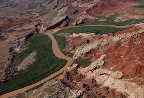
Suddenly the brown river turns to a green lake.
(San Juan River north of Monument Valley, Utah)

Quick Change
| | |
|
Don Maxwell - Jan 01,2016
Viewers
| Reply
|
| |
Bizarre! But which way is downhill? It seems more likely that the clearer water was running into the murky than the other way around.
| | |
|
Nickens, Dan - Jan 01,2016
Viewers
| Reply
|
| |
It's the other way down, Don. It was all downhill for the rock robbing water until it encountered the leveling stop of the still dam
water! I bet there is one heck of a sandbar growing down there.
| | |
|
Don Maxwell - Jan 01,2016
Viewers
| Reply
|
| |
Ah. Sort of like a tidal bore without a tide? I confess to not looking at the hi-res photo before--not that I would have been thinking any more clearly, but at least I would have seen that it's a more complicated situation than I originally thought. I hadn't paid attention to that narrow streak of brownish water (or whatever it is), either.
| | |
|
Nickens, Dan - Jan 08,2016
Viewers
| Reply
|
| |
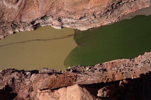
One moment the world is murky brown, the next it is crystal green.
(San Juan River bumping into Lake Powell north of Monument Valley, Utah)
Sudden Clarity
| | |
|
Nickens, Dan - Jan 08,2016
Viewers
| Reply
|
| |
A rock world laid bare under the weight of the river.
(San Juan River north of Monument Valley, Utah)

Clear Cut
| | |
| | | | | | | | | | | | | | | | | | | | | | | | | | | | | | | | | | | | | | | | | | | | | | | | | | | | | | | | | | | | | | | | | | | | | | | | | | | | | | | |