|
|
 |
|
|
|
|
|
|
|
|
Posted By:
Don Maxwell
Date Posted:
Oct 17, 2015
Description:
Didn’t it rain, children, didn’t it rain! https://www.youtube.com/watch?v=3NFywQdeKSo
Sister Rosetta Tharp had it right! Fortunately, hurricane Joaquin is apparently heading for Norway instead of the US east coast—and a good thing, too, because the Mid-Atlantic region has already had more than enough rain, and the storm surge has raised the high tide well beyond flood level along the coast.
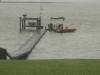
And here on the James River in eastern Virginia, too. This was the view an hour before high tide this evening.
The normal high water level is about three or four feet lower.
Date Taken:
2015-10-02
Place Taken:
The Taj Mahouse at Shangri-La-di-da on the James, in Virginia, USA
Owner:
Don Maxwell
File Name:
IMG_7689.jpg - Photo HTML
Full size - <img src="/show.php?splash=6vuCf9ESoh">
Medium - <img src="/show.php?splash=6vuCf9ESom">
Thumbnail - <img src="/show.php?splash=6vuCf9ESos">
Category:
Max_Pix
|
|
|
|
|

Click on photo to view the original size. |
| Viewers
|
|
|
|
|
|
|
|
|
|
|
Read what others had to say:
|
|
|
|
|
|
|
 |
Don Maxwell - Oct 02,2015
Viewers
| Reply
|
| |
Next door, Neal’s beach was awash, too. That's where we hope to taxi ashore next Saturday (the 10th).
Grrrrr. The site won't let me post a photo, neither with my Mac, nor the iPhone. Error 404 again.
Hm. I was able to save the photo (below) with the iPhone--but doing so deleted the text and I had to add it after uploading the photo.
| | |
|
Dennis Scearce - Oct 02,2015
Viewers
| Reply
|
| |
We're expecting 4"" - 7"" here on Lake Norman. Duke Energy is letting water from Lake James, Lake Hickory and Lookout Shoals lake into Lake Norman. But, a foot of water from Lake James equals only 1 inch of water in LKN. Plus we were about 5"" lower than the seasonal target and are glad to have the water.
| | |
|
Don Maxwell - Oct 02,2015
Viewers
| Reply
|
| |
Next door, Neal’s beach was awash, too. That's where we hope to taxi ashore next Saturday (the 10th).
The beach is well to the left of those trees.
| | Attachments:

image
| | |
|
Don Maxwell - Oct 03,2015
Viewers
| Reply
|
| |
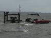
Whew! So far, so good. A few minutes after high tide this morning, and all's swell. The water is still about 3 feet higher than a normal high tide, though, because of four days of nor'easter, with another two days of it coming.
| | Attachments:
image
| | |
|
Don Maxwell - Oct 04,2015
Viewers
| Reply
|
| |
New Bay. This is Neal's beach next door. No worries about taxiing across the sand today.
| | Attachments:

IMG 7776
| | |
|
Don Maxwell - Oct 04,2015
Viewers
| Reply
|
| |
Party on the ospreys' pier--not even for seagulls today. (The ospreys left for the Bahamas late in
August.)
| | Attachments:
IMG 7774
| | |
|
Steve Kessinger - Oct 03,2015
Viewers
| Reply
|
| |
Ach. The Osprey nest is almost waterfront property.
| | |
|
John Dunlop - Oct 04,2015
Viewers
| Reply
|
| |
Yikes!
| | |
|
Dennis Scearce - Oct 04,2015
Viewers
| Reply
|
| |
One of the fun things about living on the lake is clearing the "runway" after a heavy rain / high wind. This was floating under ouir dock this morning so we had to retrieve it from the lake before it floated out in the main channel. This one is probably large enough to spot before touching down but many of the pieces are pieces of 2x6 about a foot long and are near invisible when floating. Barbara wants to re purpose it somehow. I'm voting for whacking it up with the chainsaw and hauling it to the land field.
| | Attachments:

washed up dock 1 10-04-15
| | |
|
Paulo Constantino - Oct 04,2015
Viewers
| Reply
|
| |
Gather a few more of those, and you'll have a Searey dock. I've had row boats and even paddle boats, show up on our beach. Lucky for their owners, it's
a small lake and easily retrieved.
| | |
|
Don Maxwell - Oct 04,2015
Viewers
| Reply
|
| |
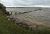
This was low tide this afternoon. Normally the water would be about 6 feet lower.
| | Attachments:
image
| | |
|
Don Maxwell - Oct 04,2015
Viewers
| Reply
|
| |
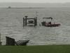
And this is 3.5 hours before high tide. The wind is still 20G30.
| | Attachments:
image
| | |
|
John Dunlop - Oct 05,2015
Viewers
| Reply
|
| |
Don, how come you felt it safe enough to leave the boats tables and chairs out there?
| | |
|
Don Maxwell - Oct 05,2015
Viewers
| Reply
|
| |
John, partly it's because the water rose so quickly that no one was ready for it. One tide was normal, and then next--about 6 hours later--was REALLY high. Hurricane Joaquin hadn't even reached the Bahamas yet when that happened. We had had several days of warm front rain at that point, but the wind was exactly right to push the whole damned river upstream.
Other than that, the waves have been normal for 20 knot whitecaps, and the barge just rides over them fairly smoothly. It's attached to the pier with two stainless steel chains and a 5/8 inch rope. The powerboat is up on the lift as far as it will go. The bottoms of the lift crosspieces were about 1.5 feet above the highest wave crests at the highest high tide, so that was okay, too. The table and chairs have been roped to the pilings for several years. I got tired of locating them underwater and hoisting 'em back up on the pier. I thought of bringing them to shore, but not until the water was high enough over the pier to make that seem like a dumb idea. We had a big plastic box out there to hold life jackets. It was tied to pilings at two points and seemed to be doing fine--until one of the tie-points broke off, so I did bring one that in.
I think the water is starting to go down now. Tonight's high tide (10:34 PM) will be the test of that. So far, my ""restoration"" of the river bank has worked well, and there was no damage visible as of low tide this afternoon. There's a lot of driftwood on the beach--including a 20 inch diameter tree trunk--but that's not a big deal. A big deal would be to have the pier decking wash away again, as it did three years ago.
(""Restore"" turned out to be the magic word when I was trying to work out permissions with the agencies that administer the Chesapeake Bay Act. All five of them had hoops ready for me to jump through, and erosion control was the most persnickety. Finally one day I just said off-handedly to the erosion control specialist, ""Well, maybe I'll just restore it [the river bank]."" ""Oh, fine,"" she said, closing her file folder. I never heard from her again. So I restored it by digging up 762 five-sided anchor blocks that had been in the original owner's wall that failed in 1991. Instead of stacking them vertically, as they originally were, I laid them flat on what had become a 45º slope, with the blocks staggered so that the five sides interlocked. But first I laid down a heavy, woven, porous plastic fabric designed for that purpose, and laid the blocks on top of it. Above the blocks I used a plastic mesh like heavy duty chickenwire and planted grass and switchgrass to grow through it. All of that stuff has survived the high water and waves.)
| | |
|
John Dunlop - Oct 08,2015
Viewers
| Reply
|
| |
I'm exhausted already! 
| | |
|
Don Maxwell - Oct 04,2015
Viewers
| Reply
|
| |
High tide this evening--you've been waiting for it, right? It's higher than ever. Here's the best shot I could get in the dark with light rain. The orange stripe is about 6 feet higher than normal high water. You can see it in the ""This was low tide..."" post above.
| | Attachments:

IMG 7862
| | |
|
Don Maxwell - Oct 05,2015
Viewers
| Reply
|
| |
This morning'so high tide was about a foot lower than last night's. The wind was still around 20G30, but is predicted to drop off later today--so I think we're past the highest water now, and there seems to have been no significant damage. (But it's good that I added 70 big kagscrews to the pier structure just before the water began to rise.)
I'm glad not to live in South Carolina. They really got rain this time. We mostly just got the wind--but for more days in a row than I've seen here before.
| | Attachments:

image
| | |
|
|
|
|
|
|
|
|
|
| |
- About Searey.us -
- Contact Searey.us -
|
- Privacy Statement -
- Terms of service -
|
Copyright © 2024 Searey.us & Brevard Web Pro, Inc. -
Copyrights may also be reserved
by posters and used by license on this site. See Terms of Service for more information.
|
| |
- Please visit our NEW
Chapter Place Website at: chapterplace.com or
Free Chapter Management Website at: ourchapter.org. Good for all chapters, groups or families. |
| | | | | | | | | | | | | | |