|
|
 |
|
|
|
|
|
|
|
|
|
|
|
|
|

Click on photo to view the original size. |
| Viewers
|
|
|
|
|
|
|
|
|
|
|
Read what others had to say:
|
|
|
|
|
|
|
 |
Don Maxwell - Aug 17,2015
Viewers
| Reply
|
| |
After tiring of flying around in circles I flew south to the James River and then headed downstream. Soon I came to the city's drinking water intake. The water is diverted into those impoundments, where most of the silt settles out. Richmond has excellent drinking water, by the way.
| | Attachments:

RichmondWaterIntake
| | |
|
Don Maxwell - Aug 17,2015
Viewers
| Reply
|
| |
A short distance farther downstream is Byrd Park--one of its lakes in the background--and the carillon, with the bell console at the top.
| | Attachments:

Carillon
| | |
|
Don Maxwell - Aug 17,2015
Viewers
| Reply
|
| |
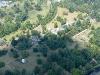
Just downstream of the carillon is Maymont Park, which used to be the private 100 acre estate of the Dooley family. The Doleys willed it to the city in 1925. You can see their house in this shot.
| | Attachments:
MaymontPark-DooleyMansion
| | |
|
Don Maxwell - Aug 17,2015
Viewers
| Reply
|
| |
Another view of Maymont Park, with the mansion at the left. The circles are the origin of a kind of fountain that cascades water about 100 vertical feet down a slope to the Japanese Garden and eventually into the old flatboat canal that parallels the James River, just below the railroad line, out of the frame.
| | Attachments:

MaymontPark-JapaneseGarden
| | |
|
Don Maxwell - Aug 17,2015
Viewers
| Reply
|
| |
Richmond is built on the fall line and has about five miles of whitewater rapids right downtown. Most of that part of the river is inside the inner ring of KRIC''s Class C airspace and, because I didn''t feel like calling up Potomac Approach that day, i just turned south and rejoined the river where it emerges from Class C into Class E airspace.
That location is easy to find because it''s where the relatively new Pocahontas Parkway crosses the river. The exhorbitant toll keeps bridge traffic to a minimum.
Too bad about skipping the downtown part of the river, though. It''s some 400 years old and brand new, as well. Another time for that.
| | Attachments:

PocahontasParkwayBridge
| | |
|
Don Maxwell - Aug 17,2015
Viewers
| Reply
|
| |
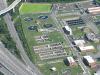
The Pocahontas Parkway connects with I-95 and VA 150 just west of the river (which flows due south there). We often drive along the road you see pointing to the upper left corner of this photo--south-ish in real life. From the road you're hardly aware of what's going on just to your right. Unless the wind is from the west, in which case your nose knows first.
The wastewater plant is said to be quite efficient; it gets enough of the waste out of it to satisfy the EPA. Except during heavy rains. The problem is, like many southern cities, Richmond's storm sewers empty into the sanitary sewers. That's nice for dilution, but not exactly <I>nice</I>.
| | Attachments:
WastewaterPlant
| | |
|
Don Maxwell - Aug 17,2015
Viewers
| Reply
|
| |
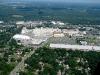
Just a little way downstream from the Pocahontas Parkway Bridge is where Richmond has long manufactured death. Oh, sorry! I mean, where the call for Phillip Morris was made. It's one of the larger cigarette manufacturing plants. I-95 passes by the front door, but the river keeps its distance.
| | Attachments:
CallForPhillipMorris
| | |
|
Don Maxwell - Aug 17,2015
Viewers
| Reply
|
| |
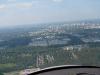
If you should decide to fly a wide 360 to the right just downstream from Phillip Morris, as I did that day, when you're heading north the city looks like this.
| | Attachments:
Richmond-South
| | |
|
Don Maxwell - Aug 17,2015
Viewers
| Reply
|
| |
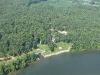
Continue your right 360 until you're flying south again, right over the river. You'll soon come to Jimmy "Big Bad John" Dean's estate. If you don't know his songs, you might know his sausages. He died a few years ago, and I heard that his widow, Donna, has remarried. Or not.
| | Attachments:
JimmyDean
| | |
|
Don Maxwell - Aug 17,2015
Viewers
| Reply
|
| |
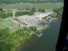
Below Jimmy Deans' place is the Osborne Marina. It has three fine, new concrete ramps leading up to the parking areas and a restaurant. Alas, the ramps are a great disappointment to me. I measured the width, and the widest ramp is approximately 32 feet wide. So in theory a Searey <I>ought</I> to fit between the high side walls. Barely. Tsk.
| | Attachments:
OsborneMarina
| | |
|
Don Maxwell - Aug 17,2015
Viewers
| Reply
|
| |
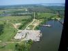
In an oxbow below the Osborne Marina is the Richmond Yacht Basin. (There are lots of other marinas and yacht clubs on the river, but these are the ones I happened to fly over yesterday.)
| | Attachments:

RichmondYachtBasin
| | |
|
Don Maxwell - Aug 17,2015
Viewers
| Reply
|
| |
And next I flew over a sand barge port, one of many in this area. This is the flatland, and there's a lot of sand hereabouts. Virginia sends many tons (and tonnes) of it to other parts of the US and to other countries, too. The James is navigable by ocean-size ships up to the fall line, so even though it's at least 100 miles by water from the Atlantic, Richmond has been a seaport for 400 years.
From the sand barge port I flew on downstream about 15 miles from where the Appomattox River joins the James at Hopewell, for a visit with my pal, Tommy Crump, who lives on a bluff near Fort Powhatan, at the last narrow part of the James before Gibraltar.
| | Attachments:
SandBargePort
| | |
|
|
|
|
|
|
|
|
|
| |
- About Searey.us -
- Contact Searey.us -
|
- Privacy Statement -
- Terms of service -
|
Copyright © 2024 Searey.us & Brevard Web Pro, Inc. -
Copyrights may also be reserved
by posters and used by license on this site. See Terms of Service for more information.
|
| |
- Please visit our NEW
Chapter Place Website at: chapterplace.com or
Free Chapter Management Website at: ourchapter.org. Good for all chapters, groups or families. |
| | | | | | | | | |