 |
|
News
View |
|
All News |
Add News |
Emoticons |
Mark Unread
|
|
|
|
|
|
|
|
|
 Previous Item - Chap from Down Under Previous Item - Chap from Down Under
This will go to the previous thread in this topic. |  Favorite option: If you want this item to be marked as a favorite, click on the black heart.
Sectionals in Google Earth
Favorite option: If you want this item to be marked as a favorite, click on the black heart.
Sectionals in Google Earth |
|  Next Item - $100 BBQ in North Carolina Next Item - $100 BBQ in North Carolina
This will go to the next thread in this topic. |
|
|
|
 |
Don Maxwell - Sep 12,2008
Viewers
| Reply
|
| |
The October issue of Plane & Pilot magazine contains an article describing how to get sectional, terminal, and other aviation charts in Google Earth. It's really cool because you get all of the usual features, such as terrain and 3D buildings and the satellite maps, AND aviation charts that you can make more or less transparent with a slider. There's lots more, as well.<br /><br />If you can't wait for a copy of the magazine, try this address: <br /><br /> <a href="http://www.wikihow.com/Overlay-Sectional-Aeronautical-Charts-in-Google-Earth">http://www.wikihow.com/Overlay-Sectional-Aeronautical-Charts<br>-in-Google-Earth</a><br /><br />and scroll down to 'Sectional data download', in the 'Sources and Citations' section. Click on that link and in a few minutes you'll have a new section in the Places section of Google Earth. But DO buy the magazine--support the guys who did the work.<br /><br />(Note: you have to have Google Earth installed on your Windows computer for this to work. If you're dial-up only--well, never mind.)
| | |
|
Don Maxwell - Sep 13,2008
Viewers
| Reply
|
| |
It's also possible to use a browser instead of Google Earth, although you won't have nearly as much control over what you see. Try this link, that's on the (above) WikiHow page: <a href="http://www.gelib.com/maps/Sectionals/Aero-Charts-GEPlugin.html">http://www.gelib.com/maps/Sectionals/Aero-Charts-GEPlugin.ht<br>ml</a><br /><br />There you can download and install an add-on that will enable you to display the complete set of US charts in your browser. (In Firefox--I don't know about IE.) With that add-on installed you can:<br /><br />Zoom the view with Left Arrow (or Left mousebutton+move mouse or Scrollwheel)<br /><br />You can tilt and rotate the view with Ctrl (or Shift) + Left Arrow (or left mousebutton). A scrollwheel works, too.
| | |
|
Don Maxwell - Sep 13,2008
Viewers
| Reply
|
| |
Here are two screenshots from my browser--the overview of all contiguous US sectional charts (Alaska is a separate view) and a 3D view of New York City from the south and inside the Hudson River VFR flyway (or helicopter route). The same views are available in Google Earth, but with lots more control over everything.<P><img src="/show.php?splash=TZTBJ6001h&zinlinez" alt="SectionalCharts"><P><img src="inline/10092-HudsonFlyway.jpg" alt="HudsonFlyway"><P>In the Hudson River view, you're at maybe 600 feet AGL, just past the Verrazano Narrows Bridge, and looking north. The Hudson River is straight ahead. In Google Earth you can turn 3D buildings on and "fly" up (or down) the river, looking at them.<!-- >'"><br><font color=red size=6>' or > missing in user HTML. Please fix the HTML.</font> -->
| | Attachments:
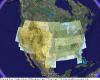
SectionalCharts
| | |
|
Kenneth Leonard - Sep 13,2008
Viewers
| Reply
|
| |
So Don - is that the floor of the class B airspace in grey over your head? Or just a haze layer?
| | |
| | |
|
|
|
|
|
|
|
| |
- About Searey.us -
- Contact Searey.us -
|
- Privacy Statement -
- Terms of service -
|
Copyright © 2024 Searey.us & Brevard Web Pro, Inc. -
Copyrights may also be reserved
by posters and used by license on this site. See Terms of Service for more information.
|
| |
- Please visit our NEW
Chapter Place Website at: chapterplace.com or
Free Chapter Management Website at: ourchapter.org. Good for all chapters, groups or families. |
| | |