|
|
 |
|
|
|
|
|
|
|
|
|
|
|
|
|

Click on photo to view the original size. |
| Viewers
|
|
|
|
|
|
|
|
|
|
|
Read what others had to say:
|
|
|
|
|
|
|
 |
Philip Mendelson - Sep 20,2007
Viewers
| Reply
|
| |
Hey Don, reminds me of a cross country I made a number of years ago in a 172.<br />The batteries died in my hand held GPS. The Orlando VOR was down for repairs.<br />The weather was marginal, I flew IFR, I followed I-4 home! I follow roads!
| | |
|
Dennis Scearce - Sep 20,2007
Viewers
| Reply
|
| |
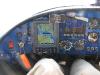
Where's the little wind direction arrow on your D10A. Installing my EDC and buying the OAT probe are on my short list because I liked that feature. Do you not use it now?
| | |
|
Don Maxwell - Sep 20,2007
Viewers
| Reply
|
| |
Aha! That's a neat little gotcha, Dennis. To compute the wind direction and velocity, Dynon needs the GPS to tell it the track and ground speed. And my friends at PAX River had put the kibosh on that. The arrow came back as soon as I got out of range.
| | |
|
Charles Pickett - Sep 21,2007
Viewers
| Reply
|
| |
I did not know they could do that.
| | |
|
Eric Batterman - Sep 21,2007
Viewers
| Reply
|
| |
They can and do. See link. You can get GPS notams, but they do not usually show up unless specifically asked for (click the button for view all GPS notams)
| | Attachments:

GPS denial
| |
| Attachments:
GPS NOTAMS
| | |
|
Don Maxwell - Sep 21,2007
Viewers
| Reply
|
| |
Thanks for posting the links, Eric. I looked for GPS NOTAMS the next day, but didn't find anything for the DC area, and wasn't able to turn up any that had expired. I haven't received a reply from the navy yet, but they'll probably just ream me out for not talking to a briefer immediately before crossing the Bay, the ######s.
| | |
|
Kenneth Leonard - Sep 21,2007
Viewers
| Reply
|
| |
So Don - is this sort of like WAAS in reverse? They put out a signal that decreases accuracy? Or do they just locally jam the satelite freqs?
| | |
|
Don Maxwell - Sep 21,2007
Viewers
| Reply
|
| |
Ken, I don't know specifically how they do it, and my GPS didn't have a take on it, either. But I imagine that there are at least two methods, one is to control the satellites' transmitters and the other, to jam signals with local transmissions. <br /><br />The scary possibility is that they can probably cause a GPS to display incorrect position and velocity, without any indication showing up on the GPS display.
| | |
|
Chris Vernon-Jarvis - Sep 21,2007
Viewers
| Reply
|
| |
I can't see how controlling or changing the GPS satellites is effective or possible in this case. The satellites, as I understand it, put out a 'blind' signal, ie. they don't actually identify each area or aircraft. Each satellite broadcasts a signal that idents it and gives a time and position stamp. The calculation of position is done in each GPS unit.<br /><br />Local jamming, on the other hand, is easy. Any signal on the right frequncy can jam another one, sometimes it does not even have to be as strong, just enough to corrupt it , and the GPS signals are very, very weak at the earth's surface.
| | |
|
Don Maxwell - Sep 21,2007
Viewers
| Reply
|
| |
I think it was probably local jamming, too, Chris. But I'll bet a lot more control of the satellites is possible than we'll ever know about. When the system first came online, the position error was something like 100 meters on civilian GPSs. Now it's more like 30 m, even without WAAS, and we know that all they did was flip a software switch to give us the improvement. For military GPS, it's probably measured in mm. Or--who knows!--maybe even nm. After all, a light nano-second is only about 30 cm--roughly one foot.<br /><br />Here's an interesting page on the subject: <a href="http://www.exn.ca/FlightDeck/News/story.cfm?ID=20000502-53">http://www.exn.ca/FlightDeck/News/story.cfm?ID=20000502-53</a><br /><br />And Wikipedia has more: <a href="http://en.wikipedia.org/wiki/Global_Positioning_System">http://en.wikipedia.org/wiki/Global_Positioning_System</a>
| | |
|
P.C. Russell - Sep 21,2007
Viewers
| Reply
|
| |
I didn't see the race track in your pictures. I'm OK with the gov. controlling things.
| | |
|
Dennis Scearce - Sep 21,2007
Viewers
| Reply
|
| |
WOW. They can even make a race track invisible??
| | |
|
Kenneth Leonard - Sep 21,2007
Viewers
| Reply
|
| |
The gov can certainly make money disappear!
| | |
|
Don Maxwell - Sep 22,2007
Viewers
| Reply
|
| |
PC, we flew directly over the RIR track at 1000 feet, both going and coming, staying below KRIC's Class C airspace, but I was too busy gawking at the relatively new top deck of the grandstand to grab the camera. That deck sits up <I>really</I> high, and the seats are several colors in a random pattern that makes them look full on tv. It's bizarre.<!-- >'"><br><font color=red size=6>' or > missing in user HTML. Please fix the HTML.</font> -->
| | |
|
Don Maxwell - Sep 22,2007
Viewers
| Reply
|
| |
Here's what that area looks like on the Washington sectional (thanks to Skyvector).<P><img src="inline/20113-PAX_R.jpg" alt="PAX-R"><P>There isn't a lot of wiggle room between the ADIZ and R-4007, and the Bay is a big place to get lost in, too.<!-- >'"><br><font color=red size=6>' or > missing in user HTML. Please fix the HTML.</font> -->
| | Attachments:
PAX R
| | |
|
Frank A. Carr - Sep 22,2007
Viewers
| Reply
|
| |
Don, this was home to me for many years, and often ATC would clear us PXT direct without any need for <br />'wiggle;-- always if IFR, sometimes even VFR. And if you're into boats, the Bay is unbeatable.
| | |
|
Don Maxwell - Sep 27,2007
Viewers
| Reply
|
| |
'POSITION LOST' Update:<br /><br />I sent an email to PAX River last week and received a reply today. Here they are (with my message at the bottom):<br /><br />===========================================<br /><br />Don,<br />Just got your message this morning. While we do periodically coordinate & conduct various benign GPS tests we had nothing going on at the time. We've called the PAX GPS Integration Lab, Air Operations, the Atlantic Test Range Control Room, the V-22 & Global Hawk Program Offices, etc. and they all profess innocence of any culpability in this incident. They also said they had not experienced or heard of any recent GPS reliability problems, and I believe them: if any rogue element at PAX River was jamming L1/2/3 all of PAX would have seen it/been impacted before you, and my phone would have been ringing off the hook. PAX River, a premier flight RDT&E facility, is dependent on access to GPS for almost all of its crucial functions (like tracking, timing, safety, surveying, guidance, airfield landings, etc.) to perform its mission.<br /><br />As for the NOTAMS, those are issued by the FAA and the most current ones should be available at check-in at any of your departure airports. If you see or hear of any GPS disruption in the future please contact my office directly; we have equipment/personnel that can possible track down the source. Of course, alerting us ASAP is crucial to catching the miscreant in the act. Also enclosed for your reading is a short, pertinent article I wrote almost eight years ago.<br /><br /><<APPENDIXS2004.doc>><br />Very Respectfully,<br />Mr. Mikel R. Ryan<br />Mid-Atlantic Area Frequency Coordination Office<br />Code 5.2.2.2, Unit 4, Bldg. 2118<br />23013 Cedar Point Road<br />NAVAIRWARCENACDIV Patuxent River MD 20670-1183<br />301-342-1532/1194 FAX X1200<br />mikel.ryan@navy.mil<br />'You can accomplish anything when you have vision, determination, and an endless supply of expendable labor.' -- Ramses II<br /><br /><br />-----Original Message-----<br />From: Don Maxwell [<a href="mailto:DonMaxwell?AbstractConcreteWorks.com">mailto:DonMaxwell@AbstractConcreteWorks.com</a>]<br />Sent: Friday, September 21, 2007 11:20<br />To: PAXR_Business Development Team<br />Cc: pilotassist@aopa.org<br />Subject: GPS Anomaly<br /><br />NAVAIR:<br /><br />This is to report a disruption of GPS reception that I experienced between about 2100Z and 2130Z on 18 September 2007, while flying a heading of 230 degrees at about 2,000 feet and passing north of Patuxent River NAS and R-4007, and over St. Mary's County Regional Airport (2W6). I lost GPS data completely for about 10-15 nm on each side of St. Mary's, and it was intermittent for about 10 nm on each side of that area. There was nothing wrong with my GPS. I suspect that someone at your installation was responsible.<br /><br />Perhaps there was a NOTAM that warned pilots of disruption of GPS signals in that area on that day, but I haven't located one. <br /><br />Fortunately, the weather was excellent for flying, and I knew my heading. Also, my GPS did not report falsely; it merely reported 'Position lost' and 'WAAS lost.' <br /><br />However, if the conditions had been less favorable, flight through that area could have been made difficult by the loss of the GPS signal. The Bay is large, and the distance between R-4007 and the DC ADIZ is small.<br /><br />I fly through there fairly often and would like to be confident that GPS will not be disrupted without plenty of advance warning. Furthermore, such warnings should be clear and proactive--pilots should not have to dig for it in obscure places or interpret arcane language in order to fly safely.<br /><br />So I'll be grateful for any information you can give me about what disrupted GPS reception on the 18th, and I hope that you will let me and other pilots know well in advance of any future disruptions that you might be aware of. You may find it convenient to notify me of future disruptions at this email address.<br /><br />=Don Maxwell<br />
| | |
|
Don Maxwell - Sep 27,2007
Viewers
| Reply
|
| |
Here's Mikel Ryan's article, in .doc format:<br /><br />And here's my reply to him:<br /><br />=======================================<br /><br />Mikel,<br /><br />Thanks for your reply and for your interesting article about GPS jamming. <br /><br />Thank you also for trying to find out who or what might have been responsible for the loss of GPS signal I experienced.<br /><br />If your innocents weren't disrupting the GPS, then I have no idea what might have caused my receiver to lose the signals--although I'm reasonably confident that the GPS itself wasn't at fault. Except for that one stretch between R-4007 and the ADIZ that one day, it had worked flawlessly for several hundred hours, including a number of trips to Florida, Iowa, northern Ontario, and Boston, and has continued to do so for another 3+ flying hours since then. It has an external amplified antenna, by the way, and is able to get good locks on satellite and WAAS signals. Except for right then and right there.<br /><br />Maybe it's just one of those Great Mysteries that can never be understood. (I'll say in that regard, however, that I was an aircraft radio repairman in the US Army, back in The Dim Ages, and although I'm not at all up on modern military technology, I may yet have some inkling of how that stuff works and how it might be employed.)<br /><br />In case you or anyone else is curious, I'll send you a composite of four photos that I took while The Mystery was in progress. They probably won't tell you much, other than the time and general location, but I don't know what else to do with them. I'll attach them to a separate message, in case your email filters are set to intercept messages containing attachments.<br /><br />And thanks again for your interest.<br /><br />=Don<br />
| | Attachments:
APPENDIXS2004
| |
| Attachments:

APPENDIXS2004
| | |
|
Don Maxwell - Sep 27,2007
Viewers
| Reply
|
| |
And one further thing that interested me--Ryan's mailing list. Here's a portion of the header of his message, with the list at the bottom, in the To: and Cc: lines:<br /><br /><br />X-MimeOLE: Produced By Microsoft Exchange V6.5<br />Content-class: urn:content-classes:message<br />MIME-Version: 1.0<br />Content-Type: multipart/mixed;<br /> boundary='----_=_NextPart_001_01C80119.3866438F'<br />Subject: GPS Anomaly<br />Date: Thu, 27 Sep 2007 11:15:20 -0400<br />Message-ID: <BF464C4C4AB4DF488E9051CF6B4D816C070E16C5@naeanrfkez02><br />X-MS-Has-Attach: yes<br />X-MS-TNEF-Correlator: <br />Thread-Topic: GPS Anomaly<br />Thread-Index: AcgBGTg7xxt3YkzeRy2pdyiCk/7/Kw==<br />From: 'Ryan, Mikel R. USNUNK NAVAIR 5.2.3.3' <mikel.ryan@navy.mil><br />To: 'Craft, Robert CIV NAVAIR 5.2.2.2' <robert.craft@navy.mil>,<br /> <DonMaxwell@AbstractConcreteWorks.com><br />Cc: 'Tarr, Rick CTR NAVAIR AD5.0 B304' <richard.tarr@navy.mil>,<br /> 'Hill, Larry D. CIV NAVAIR' <larry.hill@navy.mil>,<br /> 'Robert Goddard' <robert.n.goddard@navy.mil>
| | |
|
Don Maxwell - Sep 27,2007
Viewers
| Reply
|
| |
No, not THE Robert Goddard. That one, Robert H., is long dead and apparently had no children.
| | |
|
Dan Nickens - Sep 27,2007
Viewers
| Reply
|
| |
On or about the same date, Don, I was flying a SeaRey out over the high plains. The morning weather briefer included a warning of possible GPS outages during the day. It was a possibility turned reality for much of the day's flight, stretching from Arizona into New Mexico.
| | |
|
Dennis Scearce - Sep 27,2007
Viewers
| Reply
|
| |
It's 'em dang sunspots again...
| | |
|
Dave Lima - Sep 27,2007
Viewers
| Reply
|
| |
Wow! Quite the explanation Don, however I would expect nothing less from a professor.
| | |
|
Kenneth Leonard - Sep 27,2007
Viewers
| Reply
|
| |
Personally Don, I think it's all the static coming from D.C. ...
| | |
|
Don Maxwell - Oct 02,2007
Viewers
| Reply
|
| |
Oh, my. Is there no end to The Mystery? I received this response from my PAX River correspondent. (His message is below my reply to it.)<br /><br />===================================================<br /><br />Interesting idea, Mike. I hadn't thought seriously that it might have been a re-radiator--because it didn't seem likely that any have been marketed commercially with enough transmit power to jam the satellite signals for ten miles horizontally, which is about half the distance over which I lost the signal. But I suppose anything is possible. And it could have just been a coincidence that it occurred for ten miles on either side of PAX River. Maybe I should look for UFO reports on that day--ya think?. =Don<br /><br /><br />Ryan, Mikel R. USNUNK NAVAIR 5.2.3.3 wrote:<br />> Don,<br />> Thanks for the dandy photos. I too have no doubt this incident was not the result of a faulty GPS Receiver. One possible villain is an illegally-installed/amplified GPS re-radiator (see: <a href="http://www.gpssource.com/upload/GPS_Source_IRAC_Presentation.pdf">http://www.gpssource.com/upload/GPS_Source_IRAC_Presentation<br>.pdf</a> ). Too many people think that if you can buy an emitter then you can turn it on and use it as you please. The DoD is permitted to use these under very strict conditions (formal frequency assignments, no antenna/transmitter mods, fixed & interior locations only) but I doubt if all the commercial world has gotten the word. A few years ago Lowes, Home Depot & WalMart were fined big-time by the FCC for selling these things off-the-shelf.<br />> V/R<br />> Mike Ryan <br />
| | |
|
|
|
|
|
|
|
|
|
|
|
| |
- About Searey.us -
- Contact Searey.us -
|
- Privacy Statement -
- Terms of service -
|
Copyright © 2024 Searey.us & Brevard Web Pro, Inc. -
Copyrights may also be reserved
by posters and used by license on this site. See Terms of Service for more information.
|
| |
- Please visit our NEW
Chapter Place Website at: chapterplace.com or
Free Chapter Management Website at: ourchapter.org. Good for all chapters, groups or families. |
| | | | | | | | | | | | | | | | | | | | |