|
|
 |
|
|
|
|
|
|
|
|
|
|
|
|
|

Click on photo to view the original size. |
| Viewers
|
|
|
|
|
|
|
|
|
|
|
Read what others had to say:
|
|
|
|
|
|
|
 |
Don Maxwell - Jun 14,2009
Viewers
| Reply
|
| |
Oh, that is a cool shot, Dan! <br /><br />I've been trying to figure out what time it was and what direction you were flying. Orlando is about 28.5 degrees north, and it's almost the summer solstice, which would put the sun about 6 degrees south of straight up at solar noon. So it must have been pretty close to midday and maybe you were heading southish. The shadow of the prop on Gary's turtledeck is almost perfectly centered, too. Your slightly fuzzy shadow on the ground gives away that your altitude wasn't too much greater than his--a few hundred feet maybe? Or should I have stuck to interpreting poems?
| | |
|
Dan Nickens - Jun 14,2009
Viewers
| Reply
|
| |
As with poems, Don, photographic interpretation can be an art form. To aid in your interpretation, here are more data. The picture was taken after a leisurely lunch at Gator Joe's (about 1400 local?). The actual location is 28deg54'43.61'N, 81deg47'50.04'W (by Googling Earth), or between Buck and Cabbage Hamocks over reclaimed marsh (formerly a muck farm). Since Catherders rarely bother with compass direction, the more accurate indication is the direction of the canal Gary had just flown over. It lies in an east-west orientation and he was headed to Lake Yale from Lake Griffin, or eastbound. My fuzzy shadow is hopefully a function of height (I was several hundred feet above Gary) and not airframe vibration. So, what do you think motivated Gary to hydroaviate instead of mow his grass?
| | |
|
Don Maxwell - Jun 14,2009
Viewers
| Reply
|
| |
Gary was headed straight into the sun, Dan: the shadows fall directly behind him and the shadow of his prop falls on the turtledeck. Florida is close to the western edge of the Eastern time zone so in that area 1400 DST is probably somewhere around 1230 sun time. So the sun should have been a little east of south. Therefore, it seems that he was heading mostly south just then. Of course, I wasn't there and you were, so that's probably all just hooey.<br /><br />But what really interests me now is that just a bit west of Cabbage Hummock is an area that reminds me of the fuselage of a Cessna  that was tied down on a ramp after the prop of a passing Cherokee ate it up. (Probably was different airplanes, but the image of slices is indelible in my memory.) that was tied down on a ramp after the prop of a passing Cherokee ate it up. (Probably was different airplanes, but the image of slices is indelible in my memory.)
| | Attachments:
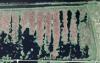
Picture 52
| | |
|
Dan Nickens - Jun 15,2009
Viewers
| Reply
|
| |
Did you also notice a lot of greenish water in photos from this area, Don? That is because the Harris chain of lakes emptying into the Ocklawaha River are eutrophic. And that is largely because of an agricultural practice dating back to WWII where the farmers took marshlands and lake bottoms, built dikes around them, and then pumped the water out. The soil was very rich and the area was famous for its vegetables and corn. The constant pumping of water from the marshy farmlands full of fertilizer (and pesticides) went on for decades. During the 1970's the clear water of the lakes hit a tipping point: they died. In the 1980's the environmental agencies began negotiating with the farmers to clean up their act. Finally, in the 1990's, the taxpayers simply paid for the former marshlands that never really belonged to the farmers anyway. The strange marshes you see are part of the reclamation of this marshland.<br /><br />And, if you know Catherders, you know that direction is largely unpredictable, random and irrelevant.<br />
| | Attachments:

Upper Oklawaha River Restoration
| | |
|
Don Maxwell - Jun 15,2009
Viewers
| Reply
|
| |
Oh, is that green stuff water? I thought it was croquet fields and shuffleboard courts.
| | |
|
|
| |
- About Searey.us -
- Contact Searey.us -
|
- Privacy Statement -
- Terms of service -
|
Copyright © 2024 Searey.us & Brevard Web Pro, Inc. -
Copyrights may also be reserved
by posters and used by license on this site. See Terms of Service for more information.
|
| |
- Please visit our NEW
Chapter Place Website at: chapterplace.com or
Free Chapter Management Website at: ourchapter.org. Good for all chapters, groups or families. |
| | | | | |