|
|
 |
|
|
|
|
|
|
|
|
Posted By:
Hal Brown
Date Posted:
Nov 5, 2011
Description:
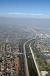
“The boat was delayed. Now it won’t make the show on time. Can you go back and get the SeaRey?” Adam asked.
There are probably a lot of questions I should have asked. I didn’t. The only important answers were that Pia Romeo was coming back to Florida and I was going to get her.
Well, there was one more important point: “You’ve been gone more than you’ve been home,” Ann said right flatly.
True. Answer: “Come with me.”
Her Answer: “And ride for hours and hours in a cramped little airplane? I don’t think so.”
Hmmm……okay, well….”Let’s meet somewhere fun.”
That worked. Now the problem was that I had a schedule. I had to put the airplane back together and fly to Taos, New Mexico arriving when she did.
Like all plans, they are just concepts of the future. Reality always gets in the way. Like the reality of making arrangements with the shipping company, the airport, a towing company, the airport and some local help. None of them bought in to my plan. Consequently it was a jam getting the plan stuffed in to the allotted time. It was late afternoon before I left LA.
At least I wasn’t delayed by rush hour traffic.
Date Taken:
Nov 5, 2011
Place Taken:
East LA, CA
Owner:
Dan Nickens
File Name:
Leaving_LA.jpg - Photo HTML
Full size - <img src="/show.php?splash=SZOPI0000h">
Medium - <img src="/show.php?splash=SZOPI0000m">
Thumbnail - <img src="/show.php?splash=SZOPI0000s">
Category:
493, Travails of Pia Romeo
|
|
|
|
|

Click on photo to view the original size. |
| Viewers
|
|
|
|
|
|
|
|
|
|
|
Read what others had to say:
|
|
|
|
|
|
|
 |
Dan Nickens - Nov 05,2011
Viewers
| Reply
|
| |
“You can go west across the city, but follow the rivers,” I was advised by the local sport pilot guru.<br /><br />“The rivers? What rivers?”<br /><br />“Well, the drainage ways. Most of the guys with light airplanes try to stay close to them in case of an emergency landing. There’s no other place else to go.”<br /><br />How about landing on top of a tractor trailer? That’s what they’d do at an air show.<br />
| | Attachments:
Urban Seaplane Routing
| | |
|
Dan Nickens - Nov 05,2011
Viewers
| Reply
|
| |
Landing on a semi trailer as it cruised the freeway might be a bit challenging on the curves.
| | Attachments:

SeaRey Carriers
| | |
|
Dan Nickens - Nov 05,2011
Viewers
| Reply
|
| |
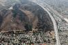
It’s great to be in the clear, even if it’s a bit murky down below.<br /><br />The smog looked nasty, but it could be worse. In 1954 they had to shut down schools and industry for most of the month of October because of it. The mountains make a great trap for the city’s pollution. Now, if they had a fleet of zeppelins fitted with smog eaters they could mine the stuff.<br />
| | Attachments:
Clear Cruising
| | |
|
Dan Nickens - Nov 05,2011
Viewers
| Reply
|
| |
Could be a temple? It looked like there were fancy graves nearby. It’s prime real estate for a body dumping ground.
| | Attachments:

Great Graves
| | |
|
Don Maxwell - Nov 05,2011
Viewers
| Reply
|
| |
Lawn mowing hell!
| | |
|
Dan Nickens - Nov 05,2011
Viewers
| Reply
|
| |
In case of geographic confusion, just check the hillside to figure out the location. Water towers work too. Old Col. Grumpy has a story about flying on a final training mission in the front of B-25. He was supposed to be working on navigation problems, but weaving around thunderstorms on a summer afternoon west of Memphis had thrown him off. Just when the instructor demanded to know their position, he spotted a water tower: “We’re smack over Smackover, sir.” Smackover, Arkansas. Sometimes you just get lucky.
| | Attachments:
Location ID
| | |
|
Frank A. Carr - Nov 06,2011
Viewers
| Reply
|
| |
Notice the auto traffic in the Freeway to the right. Ugh!
| | |
|
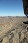
Dan Nickens - Nov 05,2011
Viewers
| Reply
|
| |
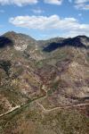
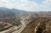
The foothills of the San Gabriel Mountains mark the edge of the coastal basin. It’s not an edge to a turbocharged SeaRey, but I took the scenic route around and up the pass anyway. Pia was happy to be flying free and fine. I could tell she was relieved to be out of her steel cage.
| | Attachments:
Basin Edge
| | |
|
Dan Nickens - Nov 05,2011
Viewers
| Reply
|
| |
The low way out of the LA basin to the east is through Cajon Pass. It is notorious for wind and turbulence and fog. Two outta three ain’t a bad day. At least the Santa Ana winds weren’t blasting through at 80 mph.
| | Attachments:
Busy Pass
| | |
|
Dan Nickens - Nov 05,2011
Viewers
| Reply
|
| |
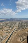
Governor Jerry’s Ditch is brings water from the north to the south through the high desert in a concrete trough.
| | Attachments:
California Culvert
| | |
|
Dan Nickens - Nov 05,2011
Viewers
| Reply
|
| |
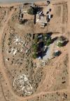
Out in the wilds of suburbia some concrete dinosaurs are turning back into limestone. Somebody’s dreamland is now just some faux fossils. (He’s probably moved to Roswell and has a fast food joint in a saucer.)
| | Attachments:
Dinos Dying
| | |
|
Dan Nickens - Nov 05,2011
Viewers
| Reply
|
| |
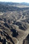
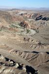
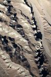
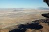
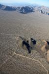
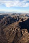
The Mohave Desert is part of the basin and range topography, an area of gigantic earth blocks dropping and rising caused by crustal thinning. The desert is in between pushed up blocks. As the blocks get pushed up and down, volcanoes slip in. Out on the flat plains some old magma is gradually becoming part of the flat basin soil.
| | Attachments:
Well Weathered
| | |
|
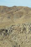
Dan Nickens - Nov 05,2011
Viewers
| Reply
|
| |
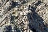
When basalt cools slowly with horizontal contractions, great columns can form. Or it could be a column storage area built by ancient aliens.
| | Attachments:
Slow Cooked
| | |
|
Dan Nickens - Nov 05,2011
Viewers
| Reply
|
| |
It’s nice to see a roadside park dedicated to rocks.
| | Attachments:
Rock Park
| | |
|
Dan Nickens - Nov 05,2011
Viewers
| Reply
|
| |
The colors are subtle, but the rocks are red, white, tan and black. That’s a pretty wild pallet for rock artists.
| | Attachments:
Colored Rocks
| | |
|
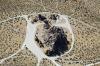
Dan Nickens - Nov 05,2011
Viewers
| Reply
|
| |
It takes a lot of work to maintain a personal pond in the desert. Sometimes it is easier just to have a nice depression and get over it.
| | Attachments:
Deserted Pond
| | |
|
Dan Nickens - Nov 05,2011
Viewers
| Reply
|
| |
Sometimes you want to live in the desert but your wife wants lakefront. Somebody always has a compromise solution....and usually they are divorce lawyers.
| | Attachments:
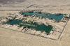
Super Sized Oasis
| | |
|
Dan Nickens - Nov 05,2011
Viewers
| Reply
|
| |
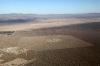
The real thing doesn’t have ponds. It’s just big and dry. Flying over it is so easy. Trying to get across on a pony would be a real adventure.
| | Attachments:
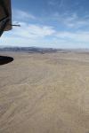
Real Desert
| | |
|
Dan Nickens - Nov 05,2011
Viewers
| Reply
|
| |
Surficially  speaking, the Mohave River is intermittent. It only flows in floods (but it can be a raging torrent when it’s wet). Most of its flow is underground. If you are crossing the desert on a pony, it’s important to know there is water just out of sight.<br /><br />I suppose it could be important to a SeaRey pilot too if the radiator hose went bust right about here! And the engine temperature was looking unusually high. It made me start wondering about those extra parts I had after putting Pia back together (foam things stuck randomly around the cowling).<br /> speaking, the Mohave River is intermittent. It only flows in floods (but it can be a raging torrent when it’s wet). Most of its flow is underground. If you are crossing the desert on a pony, it’s important to know there is water just out of sight.<br /><br />I suppose it could be important to a SeaRey pilot too if the radiator hose went bust right about here! And the engine temperature was looking unusually high. It made me start wondering about those extra parts I had after putting Pia back together (foam things stuck randomly around the cowling).<br />
| | Attachments:

Subtle River
| | |
|
Dan Nickens - Nov 05,2011
Viewers
| Reply
|
| |
The rocks are tough, but not tough enough to resist water boarding.
| | Attachments:
Washing Away
| | |
|
Dan Nickens - Nov 05,2011
Viewers
| Reply
|
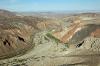
| |
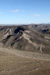
The Mojave River zigs and zags as it cuts through the old volcanic hills. There is an Indian trail that follows the river. At least 4,000 years old, it is one of the oldest known trade routes in the world. After the Spanish arrived, the Paiutes used it to take their stolen horses and oxen eastward. They brought slaves from other tribes westward to trade for stuff they didn’t steal.<br /><br />The Spanish called the river: Rio de Los Animas (the River of the Spirits). In the land rush of the 1800’s settlers followed it as the southern route to California. (The northern route got a bad reputation from the Donners.) Seeing the green of the desert stream after crossing the dry desert had it described as “The Garden of Eden.” In the 1850’s the army established a fort at Newberry Springs where cavalry mounted on camels patrolled the trail.<br /><br />There is a more modern route just off the Barstow Freeway (I-15). It’s called the Zzyzx Road. Knowing about this road can take you to the California State University Desert Studies Center and maybe win a Scrabble game some day.<br />
| | Attachments:
River Cuts
| | |
|
Dan Nickens - Nov 05,2011
Viewers
| Reply
|
| |
Lots of convoluted waterways make up Afton Canyon. It is sometimes called the “Grand Canyon of the Mohave.” It’s not nearly as deep as the National Park, but it is plenty grand.
| | Attachments:
Crinkled Creekside
| | |
|
Dan Nickens - Nov 05,2011
Viewers
| Reply
|
| |
These little dabs of rock color would make a formidable pallet for any artist.
| | Attachments:
Rock Pallet
| | |
|
Dan Nickens - Nov 05,2011
Viewers
| Reply
|
| |
The river cuts through rocks of many colors. The mostly dry river is typically wet as it cuts through Afton Canyon. Low permeability rocks lying just under the river bed? Maybe. The water disappears underground as it flows into Soda Lake.
| | Attachments:
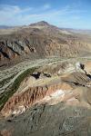
Color of Hills
| | |
|
Dan Nickens - Nov 05,2011
Viewers
| Reply
|
| |
A truly crinkled white rocky wash gives new, positive meaning to the phrase “white wash.”
| | Attachments:
White Wash
| | |
|
Dan Nickens - Nov 05,2011
Viewers
| Reply
|
| |
Soda Lake is almost the end of the line for the Mohave River. On rare occasions of exceptional flooding it may extend a little further north to reach Silver Lake. Eventually the floods subside, the lakes and river sink into the sand or evaporate into thin air.<br /><br />After the last ice age (18,000 years ago), the ancient Lake Manix covered the whole desert. It drained after a particularly big earthquake. If that happened today, the U. S. Army Corpse of Engeeneers would probably try to refill it with treated sewage from Las Vegas.<br />
| | Attachments:
River End
| | |
|
Dan Nickens - Nov 05,2011
Viewers
| Reply
|
| |
There are strange swirls on the old lake bed. Remnant tracks from ancient Indian four wheelers?
| | Attachments:

Dry Lake Bottom
| | |
|
Dan Nickens - Nov 05,2011
Viewers
| Reply
|
| |
It’s dry, but covered in vegetation. Life abhors emptiness.
| | Attachments:
Seriously Deserted
| | |
|
Dan Nickens - Nov 05,2011
Viewers
| Reply
|
| |
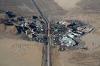
Out in the desert there is lots of sunshine. Taking advantage of that situation, a huge solar thermal power plant is under construction near Ivanpah Lake. Using 350,000 heliostat mirrors, a lot of sun power will be directed towards the central solar power towers. There will be three plants producing 390 megawatts. It’s financed by Google and guaranteed by $1.4 billion U.S. tax dollars. The sunlight hitting the central tower will turn water there to steam. Here’s a hint: don’t ever fly between the mirrors and the tower.
| | Attachments:
Future Power
| | |
|
Dan Nickens - Nov 05,2011
Viewers
| Reply
|
| |
Work on the huge solar plant in the desert means construction on a mega scale. It also means clearing out those silly mesquite bushes. It also means making a lot of naturalists angry. “But what about the Mohave National Preserve?” they say. Yep. It’s preserved for power. “Clean solar power.” Maybe barbeque roadrunner will be offered to homeless folks living in the desert.<br /><br />(I suppose “green” ethics can be situation too.)<br />
| | Attachments:
Electric Desert
| | |
|
Dan Nickens - Nov 05,2011
Viewers
| Reply
|
| |
Just across the state line is the gambling truck stop at Jean. If you don’t want to drive on into Las Vegas, you can lose your money just across the border.
| | Attachments:
Money Mecca
| | |
|
Dan Nickens - Nov 05,2011
Viewers
| Reply
|
| |
Behind these brown walls on the horizon is a later day Sin City, Las Vegas. Metamorphic rocks of the McCullough Range make a nice wall to keep people from the south from invading.
| | Attachments:
Sin City Walls
| | |
|
Dan Nickens - Nov 05,2011
Viewers
| Reply
|
| |
The Eldorado Valley south of the McCullough Range is a endorheic basin (no outlet for water) with a quite dry lake. It also has a solar plant with 18,000 mirrors focusing sunshine on tubes containing a heat transfer fluid heated to 735 F. The steam powers a turbine.<br /><br />Also in the valley is a busy Boulder City airport (KBVU). After a mere 3.6 hours the sun was too low to go any further. Pia and I covered 256 miles in that time. (At 251 pictures I was doing better than one per mile!) Subtracting time for the local test flight at Torrance, that averages out about 75 mph. “Faster is going to have to happen or I’ll be late tomorrow.”<br /><br />First, though, I called Kerry with a complaint: “Pia is running hot. I have to power back to keep her within limits.”<br /><br />“Did you put the foam baffles back in the cowling?”<br /><br />“Er….you mean that gray squishy stuff?”<br /><br />“Yep. That’s what pushes the airflow through the radiator.”<br /><br />“Oh. Goodbye.”<br /><br />Meanwhile, I scored the crew car to head over to the Railroad Pass Casino for a $40 room and a ridiculously large buffet dinner.<br />
| | Attachments:
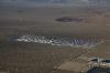
Desert Hotspot
| | |
|
|
|
|
|
|
|
|
|
|
|
| |
- About Searey.us -
- Contact Searey.us -
|
- Privacy Statement -
- Terms of service -
|
Copyright © 2024 Searey.us & Brevard Web Pro, Inc. -
Copyrights may also be reserved
by posters and used by license on this site. See Terms of Service for more information.
|
| |
- Please visit our NEW
Chapter Place Website at: chapterplace.com or
Free Chapter Management Website at: ourchapter.org. Good for all chapters, groups or families. |
| | | | | | | | | | | | | | | | | | | | | | | | | | | | |