|
|
 |
|
|
|
|
|
|
|
|
|
|
|
|
|

Click on photo to view the original size. |
| Viewers
|
|
|
|
|
|
|
|
|
|
|
Read what others had to say:
|
|
|
|
|
|
|
 |
Dan Nickens - Nov 06,2011
Viewers
| Reply
|
| |
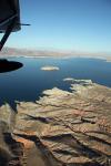
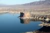
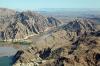
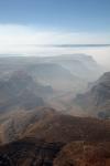
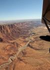
The dam and bridge were just a short deviation. And it was on the suggested traffic routing. Besides, I figured I really should do a quick circle and report my position. It’s not a mission deviation if you’re doing it for safety, right?<br /><br />“Now that I’m over it, what do I call it?” That’s not so simple a question.<br /><br />“Bush Bridge and Hoover Dam”? Well, both may be naming controversies. The dam was first called Boulder Dam because Boulder Canyon was supposed to be the dam site before switching to Black Canyon. Then at the dedication it was referred to as Hoover Dam because he was the president, though he lost the election and the new Secretary decided to make it Boulder Dam again. People eventually forgot about the depression and Hoover’s association, and, feeling good after winning WWII, the Congress named it officially “Hoover Dam.”<br /><br />So, “SeaRey reporting Hoover Dam, and, er, the big bridge?”<br /><br />The Bridge? It was meant to be a bypass of the little two lane road over the bridge. After the terrorists attacked in 2001, somebody figured it was a bad idea to have traffic on the dam. They hurriedly finished the bridge. The bridge was first known as the Hoover Dam Bypass but it could be called the Black Canyon Bypass, or the Bush II Bridge, or, since it opened in 2010, maybe it will be called the Obama Overpass.<br /><br />It is none of the above. It is the “Mike O’Callaghan – Pat Tillman Memorial Bridge”. O’Callaghan was a Korean War vet and governor of Nevada. Tillman played football at ASU and in the NFL, then went to war and was killed in Afghanistan. That was a mouthful and took up 2 minutes of radio time.<br /><br />That got me to wondering who the heck was “Lake Mead”?<br /><br />Elwood Mead was the bureaucrat that ran the Bureau of Reclamation, the agency responsible for planning and building the dam. He is memorialized through his namesake, the largest reservoir in the U.S.<br /><br />Now I had the call figured out: “SeaRey N815PR reporting over Hoover Dam and the Mike O’Callaghan, Pat Tillman Memorial Bridge at 1000’ proceeding to Lake Elwood……er, Mead.” <br /><br />Somebody answered: “Stuck mike?”<br /><br />Harumph! Everybody with a radio is an instant broadcast critic!<br /><br />
| | Attachments:
Dam Complex
| | |
|
Dan Nickens - Nov 06,2011
Viewers
| Reply
|
| |
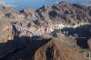
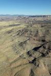
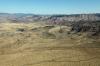
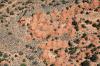
Fortification Hill is an old volcano. “Paint pots” is the colorful formation resulting from erosion of a huge pluton that grew beside it. It all required a “minor” deviation for safety (as previously noted, a suitable excuse for violating the direct flight plan). It was safer to go around the volcano and pluton than try to climb over with newly installed experimental foam radiator cooling baffles. Again, it’s just safety. The fact that I could get a better view was just an added benefit.
| | Attachments:
Lake s Edge
| | |
|
Dan Nickens - Nov 06,2011
Viewers
| Reply
|
| |
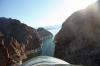
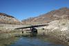
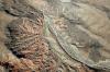
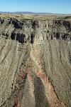
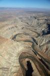
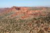
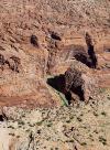
Shooting the gap through Boulder Canyon with Guardian Peak to the left and Arch Mountain to the right put me back in the right direction. I resolved to get back to that straight GPS guideline and follow it to the end!<br /><br />This is where Boulder Dam was originally proposed to be. I’m glad they moved it. The rock walls provide solid incentive to follow the planned easterly course line.<br />
| | Attachments:
Passages
| | |
|
Jeff Arnold - Nov 06,2011
Viewers
| Reply
|
| |
Why so high Dan? It seems that the fun factor would have been enhanced at a lower altitude. Lower altitued wouldn't be considered a 'deviation', would it?
| | |
|
Dan Nickens - Nov 06,2011
Viewers
| Reply
|
| |
A couple of boaters had already claimed the lower altitudes, Jeff.
| | |
|
Dan Nickens - Nov 06,2011
Viewers
| Reply
|
| |
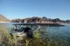
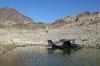
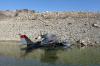
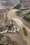
I saw a great looking beach, but there was no time for exploration. “Hmmm…wait a minute. The engine temperatures look suspiciously normal. Maybe I better stop and check on that foam.”<br /><br />The ski season must have been good to the lake. The bush along the lakeshore struggled to keep their heads above water.<br /><br />According to a local lake web site, the lake level has risen 30’ after a good winter in the Rocky Mountains. It is on track to rise another 40’ in the coming year.<br /><br />But climatologists have warned of a long term drought pattern and have predicted the water level will drop below the minimum pool level by 2017. They also said there’s a 50% chance that the dam’s storage capacity will be exhausted by 2021. Of course they predicted afternoon thunderstorms in New Mexico on an absolutely gorgeous Western day. I had to hope their predictions are as good as my planning.<br />
| | Attachments:
Flooded Bush
| | |
|
Dan Nickens - Nov 06,2011
Viewers
| Reply
|
| |
The Gypsum Ledges are jagged teeth ready to snag the unwary. Divers are cautioned to contemplate the potential collapse of over-hanging gypsum while exploring the underwater crevices.<br /><br />Hikers are cautioned to watch for Relict Leopard Frogs. Thought to be extinct in the 1950’s, they have been spotted again in springs around Lake Mead. Their habitats are springs running through the gypsum deposits. They better be ready to migrate (again) if the dam level continues to rise. I’m not sure they should rely on the climatologists’ forecasts in selecting future home sites.<br />
| | Attachments:

It s Complicated
| | |
|
Dan Nickens - Nov 06,2011
Viewers
| Reply
|
| |
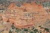
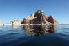
The Temple sits majestically out in the vast waters of Temple Basin. Its persistence is enhanced by its composition, including the ever tough Fortification Basalt. It’s not true that I persisted in deviating from the GPS path. It’s just that the projected path went through a mountain instead of around it.
| | Attachments:
Reflecting Point
| | |
|
Dan Nickens - Nov 06,2011
Viewers
| Reply
|
| |
There was no time for a break with a long way to go, but part of the mission was collecting photos of SeaRey stuff. And the water was perfect. And I needed to steer around the Grand Canyon Special Flight Rules Area, so I really wasn’t being deviant in turning north. And it doesn’t get any more photogenic than parked in a secluded cove out in the Wilderness surrounding the Hiller Mountains, Nevada.
| | Attachments:
Snug Cove
| | |
|
Dan Nickens - Nov 06,2011
Viewers
| Reply
|
| |
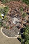
In the beach area an old campfire had been doused by the rising water level. Lake Mead has only been full enough to overflow the spillways at the dam twice: once when it was first filled (after letting the downstream river go dry) and during the great floods of the 1980's. Maybe it’s going to be making another run at it. Maybe not if the climatologists are right.
| | Attachments:
Flooded Camp
| | |
|
Dan Nickens - Nov 06,2011
Viewers
| Reply
|
| |
Nothing better to beat the late September heat than to soak Pia’s hull in cool water beside granitic washes that came into being along with the first life in the Proterozoic Era. True that letting her cool might not be a good test of my foam placement selections, but I figured there would be plenty of time for temperature tests climbing up on to the Colorado plateau.
| | Attachments:
Chillin
| | |
|
Dan Nickens - Nov 06,2011
Viewers
| Reply
|
| |
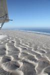
With far places to be, and having achieved an adequate state of chill, this SeaRey is ready to rock and roll. I scrupulously avoided spending (too much) time making toe prints in the soft silt by the lake.
| | Attachments:

Ready to Rock
| | |
|
Don Maxwell - Nov 06,2011
Viewers
| Reply
|
| |
Dan, that really is a sexy looking airplane--in any setting, and especially in one like this. It paint had no weight, I'd paint mine similarly. But I keep wondering if it's invisible in the air. I (usually) want to be seen easily.
| | |
|
Dan Nickens - Nov 06,2011
Viewers
| Reply
|
| |
Gee, I dunno, Don. She's easy to see from the inside. She also has a really spiffy traffic spotter tied into the GPS.
| | |
|
Dan Nickens - Nov 07,2011
Viewers
| Reply
|
| |
I had the misfortune to be on the ground watching her fly away today, Don. She was easily visible against a blue sky for a long, long way. It might not be so great against a dark gray thunderstorm cloud, but who'd be flying around one of those anyway!
| | |
|
Dan Nickens - Nov 06,2011
Viewers
| Reply
|
| |
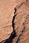
The Colorado River has nicely split Iceberg Ridge from the Indian Hills. The tilted strata on the ridge are an excellent example of movement in the Basin and Fault province. It’s also an excellent example of massive power and beautiful results. And it shows how the soft persistence of water cuts through the hardest of rocks.
| | Attachments:
Nice Cut
| | |
|
Dan Nickens - Nov 06,2011
Viewers
| Reply
|
| |
The rising lake water hasn’t quite reclaimed the cove yet. Good thing for all the chuckwallas trying to soak up the last of the summer sun. Normally I would have splashed down in the river to chase after a few of them. But not this day. I had an appointment to make.
| | Attachments:
Back Bay Cove
| | |
|
Dan Nickens - Nov 06,2011
Viewers
| Reply
|
| |
Soft and subtle colors are the funeral cloak of the dying rocks. Of course they aren’t really dying. They are just being reincarnated as sand. And that sand will get washed out into the ocean (when the dam breaks). The sand will slowly sink in the ocean and become part of the sea floor. The sea floor is slowly slipping under the land. The floor will melt to become magma. The magma will burst back up to surface and the rock will be reborn. It’s the rock’s religion. The rocks may have a paradigm shift when the sun envelops the earth and short circuits the whole thing.
| | Attachments:
Painted Wash
| | |
|
Dan Nickens - Nov 06,2011
Viewers
| Reply
|
| |
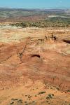
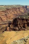
It’s a long climb out of the canyon to the Shivwits Plateau. Fortunately the Grand Wash Cliffs have built in steps. The Grand Wash, a fault line, marks the boundary between the Basin and Range province to the west, and the Colorado Plateau to the east. The Shivwits Plateau forms the northern boundary of the Grand Canyon. It rises 4000’ at the escarpment.<br /><br />Pia didn’t mind the climb. With her foam undergarments in the right place, she was keeping her cool.<br />
| | Attachments:
Steep Steps
| | |
|
Russ Garner - Nov 07,2011
Viewers
| Reply
|
| |
You otta be glad her undergarments were the right place and everything ells on her working right because where you're at looks like no where to land and if you did manage to land in one piece no one to come and save you. That's were you get the great photo's though.
| | |
|
Dan Nickens - Nov 07,2011
Viewers
| Reply
|
| |
I was glad, Russ, but I always try to have an out (and I always try not to show it in the photos). At the base of the steep steps was a nice, smooth wash....perfect in case Pia took a nap. I was being tracked by SPOTers and I had a 406 Personal Locating Beacon in case it all went badly.<br /><br />A long time ago Paige told me don't ever let the airplane take you somewhere you can't put it down easy enough to get out. I do my best to follow that advice.
| | Attachments:
Emergency Landing Options
| | |
|
Don Maxwell - Nov 08,2011
Viewers
| Reply
|
| |
Paige is a really smart guy, Dan.
| | |
|
Dan Nickens - Nov 06,2011
Viewers
| Reply
|
| |
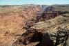
The last climb from the canyon after the Grand Wash Cliffs is a big one over the Hidden Rim Cliffs. Instead of being the result of a fault like the lower cliffs, these are erosion around their edges. <br /><br />There’s nothing hidden about them from a SeaRey. Pia and I had a grand view of the whole formation.<br />
| | Attachments:
Last Step
| | |
|
Dan Nickens - Nov 06,2011
Viewers
| Reply
|
| |
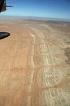
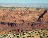
Out on the plateau there is an occasional volcanic cone sticking up. There are broad areas of lava flows indicating that most of the eruptions were not of the spectacular variety.<br /><br />Being mostly flat the plateau had the benefit of letting us fly low. The wind at altitude would have put us even further behind plan. I didn’t need to climb up to find out. It just stands to reason, right?<br />
| | Attachments:
Burned Out
| | |
|
Dan Nickens - Nov 06,2011
Viewers
| Reply
|
| |
One of the plateaus had nicely ruled lineation. Most of the plateaus are a result of resistant sandstone or limestone overlying easily eroded shale. This one tilted and eroded at just the right angle to make some nice lines. Sorta like the GPS line that I was now scrupulously following.
| | Attachments:
Long Lines
| | |
|
Dan Nickens - Nov 06,2011
Viewers
| Reply
|
| |
The Grand Canyons were smoking. It was probably not a good day for in the canyon for hikers. It was a great day up on the plateau in the Kaibab-Paiute Indian Reservation.
| | Attachments:
Smoking Chasm
| | |
|
Dan Nickens - Nov 06,2011
Viewers
| Reply
|
| |
The canyons north of the Grand one are pretty spectacular in their own right. Kanab Creek is one of the grander canyon’s tributaries.
| | Attachments:
Almost Grand Canyon
| | |
|
Dan Nickens - Nov 06,2011
Viewers
| Reply
|
| |
If you lived out in the middle of a vast, dry expanse you might be tempted to keep a little of everything too. (I would, but I’d want a hangar for my SeaRey.)
| | Attachments:
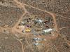
Eclectic Collector
| | |
|
Dan Nickens - Nov 06,2011
Viewers
| Reply
|
| |
If there isn’t much rain but if you catch it over a big area you can drink for a long time. Or, if you make it big enough, you can land your SeaRey in it.
| | Attachments:
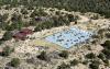
Giant Cistern
| | |
|
Dan Nickens - Nov 06,2011
Viewers
| Reply
|
| |
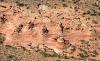
“Oh, now that doesn’t look right!” There wasn’t anything showing something like this on the GPS. It was clearly necessary to circle and verify the location. “Could be Red Knolls or Button Ridge, but either way it’s bumpy out on the Paria Plateau Sand Hills.”<br /><br />There are some local names for the rock piles: “Cotton wood teepees” or rocky “toadstools”. Geologists may say they are “erosional pillars”, but my favorite is “conical hoodoos” (anybody can see that’s what they are!).<br />
| | Attachments:
Rocky Piles
| | |
|
Dan Nickens - Nov 06,2011
Viewers
| Reply
|
| |
There should be coyotes out in them there red cliffs. Jurassic age (180 to 190 million years ago) Navajo Sandstone is a crossbedded eolian formation (or fossilized sand dunes). The sand swept across the plateau for millions of years. The dunes covered an area larger than the Sahara desert back when Utah was located on the equator. It was massive erg, or sand sea (as opposed to a massive argh which is what happens when you see how far behind schedule you are).<br /><br />The red is from rust, iron oxide, or hematite. The quartz sand grains are covered by a microscopic coating of hematite giving them the red color. But the iron pigment can be dissolved. If that happens, the sandstone becomes a bleached white. Microscopic textures within the sandstone makes for layers of various colors.<br />
| | Attachments:
Red Coyote Cliffs
| | |
|
John Robert Dunlop - Nov 09,2011
Viewers
| Reply
|
| |
Why would one want to go back to school and study all the 'ology's' when I can just sit back and listen to you and click on your photos?! I'm retired and a think I need a sabatical just to take it all in.. Thanks mate 
| | |
|
Dan Nickens - Nov 06,2011
Viewers
| Reply
|
| |
Access to Coyote Buttes is strictly limited to twenty people per day. The Bureau of Land Management has a lottery to give out permits to see this stuff. Pia Romeo won the lottery without every applying for a permit! As we headed down in to the Paria Canyon we had a view that few lottery winners will ever see.
| | Attachments:
Sand Sculptures
| | |
|
Dan Nickens - Nov 06,2011
Viewers
| Reply
|
| |
Out on the Paria Canyon uplands there is plenty of sand to see. The bands of colors are known in professional circles as Liesegang Bands. With apologies to Professor Liesegang, I prefer to refer to them as “silly candy sand stripes”.
| | Attachments:
Sandy Swirls
| | |
|
Dan Nickens - Nov 06,2011
Viewers
| Reply
|
| |
Leftovers from the ravages of water working on an old, solidified desert?
| | Attachments:

Rocky Remnants
| | |
|
Dan Nickens - Nov 06,2011
Viewers
| Reply
|
| |
An amazing sight: fluid motion fixed for eternity. Well, not exactly, unless you consider eternity to be the life span of a flight on a schedule. But maybe even longer. Not forever, but longer. Kinda like my schedule for getting to Taos.
| | Attachments:
Fixed Fluid Flow
| | |
|
Dan Nickens - Nov 06,2011
Viewers
| Reply
|
| |
If only I could have had these sand forts to play on as a kid! I might have never wanted to fly. (Yeah, right.)
| | Attachments:

Banded Brothers
| | |
|
Dan Nickens - Nov 06,2011
Viewers
| Reply
|
| |
Two lines make for a nice arrangement for soldiers and hoodoos. Hoodoos are friendlier.
| | Attachments:

Lined Up
| | |
|
Dan Nickens - Nov 06,2011
Viewers
| Reply
|
| |
The canyon walls show a smorgasbord of colors crying out for a good technical explanation. Would the explanation dilute the visual splendor? Nope. Maybe it would inhibit the resultant imagination? Nope. It was making me hungry just thinking of a great layered cake topped with ice cream!
| | Attachments:
Colored Cross Section
| | |
|
Dan Nickens - Nov 06,2011
Viewers
| Reply
|
| |
Thin cracks, cut this deep, would be scary to hike around. It was a bit disconcerting flying over them, but there were plenty of emergency landing places on the edges should Pia get too hot.
| | Attachments:
Deeply Cracked
| | |
|
Dan Nickens - Nov 06,2011
Viewers
| Reply
|
| |
Sheer rock walls drop straight down to the stream below. I was now seriously off course and behind schedule, caught up in the scenery.
| | Attachments:
Seriously Chasmed
| | |
|
Dan Nickens - Nov 06,2011
Viewers
| Reply
|
| |
White capped with the hard stuff.
| | Attachments:
Not Snow
| | |
|
Dan Nickens - Nov 06,2011
Viewers
| Reply
|
| |
The canyon opened up. A hike in the Paria Canyon is considered to be one of the very best. I nominate it for one of the very best SeaRey flights.
| | Attachments:
Cracked Open
| | |
|
Dan Nickens - Nov 06,2011
Viewers
| Reply
|
| |
A sandy slope breaks loose between rock layers. It would make a great beach, but the water is going to have to get a lot deeper first.
| | Attachments:
Sandy Break
| | |
|
Dan Nickens - Nov 06,2011
Viewers
| Reply
|
| |
Someday maybe some arches will punch through. Maybe by then some flying fool with antigravity boots will float right through them.
| | Attachments:
Future Arches
| | |
|
Dan Nickens - Nov 06,2011
Viewers
| Reply
|
| |
Growing openness gave me room to check the GPS. Uh, oh. Off course, behind schedule and over budget. Again.
| | Attachments:
Open Canyon
| | |
|
Dan Nickens - Nov 06,2011
Viewers
| Reply
|
| |
Well, as long as the schedule is already screwed up so early in the day, might as well head for the crystal waters of Lake Powell to make a new plan!<br /><br />Lake Powell is not named after some bureaucrat. It is named in honor of a one armed explorer and Civil War veteran, John Wesley Powell.<br />
| | Attachments:
Lake Approach
| | |
|
Dan Nickens - Nov 06,2011
Viewers
| Reply
|
| |
The lake is wide open for recreation. Wahweap means bitter water in the local Native American dialect. Before it was a lake, the stream would stagnate and get nasty. On a hot summer day the stagnant water was probably pretty nasty.<br /><br />No more. It’s all good.<br />
| | Attachments:
Lake View
| | |
|
Frank A. Carr - Nov 06,2011
Viewers
| Reply
|
| |
The colors of the surrounding rock formations don't look as red as I recall them from the 80's & 90's Dan. I wonder if it's time of day?<!-- >'"><br><font color=red size=6>' or > missing in user HTML. Please fix the HTML.</font> -->
| | |
|
Dan Nickens - Nov 06,2011
Viewers
| Reply
|
| |
This was midday, Frank. I'll bet you were seeing them either earlier or later in the day. The colors definitely change with the lighting.
| | |
|
Dan Nickens - Nov 06,2011
Viewers
| Reply
|
| |
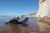
The mirrored water multiplied the lakeshore times two. The scene was perfection for reflection on the cost and value of a Lake Powell.<br /><br />The dam was completed in 1966 after the Sierra Club stopped construction of a dam further up the river. When the head of the club finally checked out Glen Canyon, he was distraught. Glen Canyon was described as the “heart of the Colorado” and stunningly beautiful (it was more of a narrow valley than a canyon).<br /><br />Dam construction dramatically altered the river environment on both sides. Upstream, an intricate riverine eco-system was destroyed. Silt and sand that previously washed downstream is filling up the canyon. Because it is in the desert and located on porous sandstone, there is a tremendous loss of water. Numerous archeological sites have been drowned.<br /><br />Downstream there are no more floods to clear out vegetation, rockslides and debris (except artificially induced floods of dubious value). The discharge water is a uniform cold temperature. The cold, clear water no longer carries sediment that previously supplied beautiful sand bars, an oasis of life for canyon life.<br /><br />On the plus side the dam completes the flood control project started at the Hoover Dam. It also provides a reservoir of fresh water to a parched Southwest. It also creates a phenomenal recreation area visited by almost 2 million people per year.<br /><br />Whatever the balance, on this day it was a perfectly made playground for one SeaRey <br />
| | Attachments:
Floating Rock
| | |
|
Dan Nickens - Nov 06,2011
Viewers
| Reply
|
| |
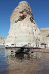
Sitting on a beach under a big rock was easy duty. It could be observed, however, that Pia appeared to have a big hat (but no cattle….if you’re from Texas, you’ll likely understand that).
| | Attachments:
Rock Hat
| | |
|
Dan Nickens - Nov 06,2011
Viewers
| Reply
|
| |
Pia was perfectly positioned for quick egress in case of rock slide or an associated lake tsunami. “Hey! That just might make the perfect excuse for a plan poorly executed! ‘There I was trying to keep to schedule when all of a sudden the mud slide buried the tires and it took all morning to dig out.’”<br /><br />Unfortunately Ann has heard it all. The only hope for getting back on schedule was to skip finding lunch at the marina.<br />
| | Attachments:
Pointed Out
| | |
|
|
|
| |
- About Searey.us -
- Contact Searey.us -
|
- Privacy Statement -
- Terms of service -
|
Copyright © 2024 Searey.us & Brevard Web Pro, Inc. -
Copyrights may also be reserved
by posters and used by license on this site. See Terms of Service for more information.
|
| |
- Please visit our NEW
Chapter Place Website at: chapterplace.com or
Free Chapter Management Website at: ourchapter.org. Good for all chapters, groups or families. |
| | | | | | | | | | | | | | | | | | | | | | | | | | | | | | | | | | | | | | | | | | | | | | | | | | | | |