|
|
 |
|
|
|
|
|
|
|
|
Posted By:
Hal Brown
Date Posted:
Nov 10, 2011
Description:
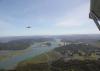
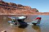
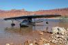
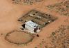
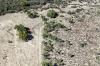
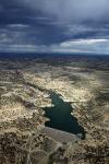
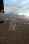
The airport at Page was busy with destruction and construction. “Down with the hills, up with the dales. Rearrange that dirt to match my sales.”
It took 3.5 hours and most of the morning to cover a nominal 240 miles from Boulder City to Page (KPGA). The slow pace may have contributed to the 465 pictures taken (almost two per mile). Or it could have been the slow pace was a function of the spectacular scenery with a direct relationship to shots per mile. Inserting constants and variables, the following approximation can be derived:
TTE = D/(Vnc-(WW+SS)/RQ), or,
Total Time Enroute = (Straight line distance)/(Normal Cruise Speed - (Waterways +Spectacular Scenes) / Responsibility Quotient),
Where Total Time Enroute = the strangely high number of flight hours showing up on Pia’s Hobbs meter, and,
Vnc = the normal cruise speed, or that speed used for flight planning by a mission oriented pilot, and,
WW = Waterways = the number of sites suitable for liquid alighting, and
SS = Spectacular Scenes = the number of sight pictures that make the pilot’s pulse rate rise by 10% or more, and,
RQ = Responsibility Quotient = a constant variable, ranging from 1 to 10, with 1 being “no worries” and 10 being “total disaster”, depending on how much trouble the pilot will be if he arrives more than 10% beyond the Estimated Time Enroute. Note that RQ cannot = 0 because if it was less than 1, “no worries”, the pilot would turn into an inanimate blob. This is known to me as the SeaRey Martial Harmony Balancing Equation.
Solving the equation for this leg:
TTE (hrs) = 240 miles/(90 mph – (28+181)/9.5)
TTE = 3.5 hours.
So sorry about the math, but it’s important to be able to predict the number of excuses that will need to be applied to the problem.
A quick check showed that following the lake to the east would add a mere 16 miles to the trip. Even at the slow pace of the past that would be a mere quarter of an hour additional (not factoring WW or SS because that calculation would significantly delay the arrival time). And, of course, it would be much safer for Pia to stay over water. Decision made: there would be a slight detour due to water.
The airport attendant offered me the use of their crew car to go to lunch. I figured I’d make up the 15 detour minutes by just grabbing lunch out of the vending machine. I ignored the calories and cholesterol in favor of a lower RQ.
Date Taken:
Nov 10, 2011
Place Taken:
Page, AZ
Owner:
Dan Nickens
File Name:
Airport_Improvement.jpg - Photo HTML
Full size - <img src="/show.php?splash=SZOP50000h">
Medium - <img src="/show.php?splash=SZOP50000m">
Thumbnail - <img src="/show.php?splash=SZOP50000s">
Category:
493, Travails of Pia Romeo
|
|
|
|
|

Click on photo to view the original size. |
| Viewers
|
|
|
|
|
|
|
|
|
|
|
Read what others had to say:
|
|
|
|
|
|
|
 |
Daniel Paul Myers - Nov 10,2011
Viewers
| Reply
|
| |
Love it...let the show begin.
| | |
|
Dan Nickens - Nov 10,2011
Viewers
| Reply
|
| |
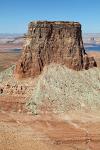
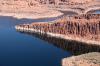
Tower Butte: when the surrounding land is devoured by the river, only the strongest remains standing. This was the first SS and I’d only been flying for 10 minutes! The spectacular butte would make the perfect background for a cowboy, Indian and SeaRey movie.<br /><br />Butte means “mound” or small hill in French. This is technically a butte, but it is no small hill (and definitely bigger than a mound). To a geographer a butte is a tall feature with steep slopes and a small top.<br /><br />If it has a bigger flat top, then it might be a mesa. The practical difference is whether the top is big enough to support a cow (or, in native American perspective, “game”), which implies there is water up there.<br /><br />Mesas start life as a nice flat plain with a hard rock top. Then rivers and stream start cutting away at the edges. When they are cut down to size, then they become buttes.<br /><br />If the flat top it is a lot, lot bigger, then it moves into plateau territory. The Colorado Plateau, for example, covers a 130,000 square miles (only 4 U.S. states have more area).<br /><br />A plateau is a relatively stable geologic area. The Colorado Plateau stayed in place by floating on a nice glassy cushion of molten rock while the area around it rose, fell, and sprouted volcanoes.<br /><br />But a cowboy, Indian, SeaRey movie wouldn’t look as good on a plateau. A mesa could work because the SeaRey could land on the top for dramatic effect. The ultimate in drama, however, would involve taking an arrow through the prop and making an emergency landing on top of the butte! (I involuntarily checked the brakes. They were good.)<br /><br />
| | Attachments:
Lone Remnant
| | |
|
Dan Nickens - Nov 10,2011
Viewers
| Reply
|
| |
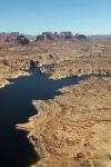
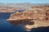
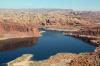
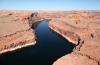
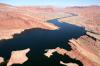
The land around the lake is finely cracked by the invading water from the dam. But the water almost cracked the dam during the floods of 1983. The dam forecasters didn’t realize the effect of heavy snow fall and rapidly rising spring temperatures would send a bunch of water down the mountains.<br /><br />When the water arrived, the operators opened the spillway just like the manual said. A few days later, the dam began to violently shake. That wasn’t in the operator’s handbook. Cavitations were shaking the dam apart.<br /><br />Emergency measures were required to artificially raise the dam height. Plywood separators were hammered together in the spillway. Both spillways were ultimately opened without undue cavitations. The dam survived by the smallest of margins. Afterwards aeration slots were added to break up the bubbles and absorb the shock.<br />
| | Attachments:
Wet Crack
| | |
|
Dan Nickens - Nov 10,2011
Viewers
| Reply
|
| |
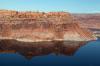
Lines are clearly drawn in stone at the edge of the Navajo Reservation. The lines are small scale brothers of larger rock fractures. Note that the large channel is nicely aligned with its smaller brothers.<br /><br />The alternative explanation involves a giant bear being dragged backwards across the plain before being tossed over the edge of the world by the great Navajo warrior, Barely Bigger than Butte.<br />
| | Attachments:
Finely Lined
| | |
|
Dan Nickens - Nov 10,2011
Viewers
| Reply
|
| |
It’s just not fair when SS combines with WW to make an insanely attractive SeaRey scene. Huge arches forming on the edges of the Cummings Plateau threw their sand down onto beaches that would be perfect for spending an afternoon coming up with excuses for busting the RQ. I should get major points for flying on. I didn’t. I never do. Sigh.
| | Attachments:
Making Arches
| | |
|
Dan Nickens - Nov 10,2011
Viewers
| Reply
|
| |
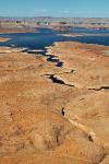
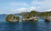
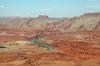
The lake eventually narrows, almost turning into a semblance of the historic river (or rivers, the Colorado and the San Juan). When you get to the fork, you can go left or you can go right, but you can’t go wrong. Either way leads into more spectacular scenery.
| | Attachments:
Flying Upstream
| | |
|
Dan Nickens - Nov 10,2011
Viewers
| Reply
|
| |
This is one bridge to nowhere that is worth every penny paid. It is 290 feet tall and 234 feet across at the base and 42’ thick and 33’ wide at the top. Native Americans called it a “rainbow turned to stone.”<br /><br />It was thought by the invaders to be an Indian myth until it was “discovered” and brought to public attention in 1909. It remained so far off the beaten path that few ever saw it until the dam provided a watery link for easy tourist access.<br /><br />For centuries it has been a sacred site for the natives. They would like to keep it that way and a suit was filed to keep unbelievers at bay. The appellate court that got the case said to close a public site would be a violation of the U.S. Constitution’s protection of religious freedom for all citizens. <br /><br />That was back in 1980. I wonder how the court would rule now if Mormon’s decided to keep non-believers out of their Salt Lake City Temple. Er…..oh, wait. They do. I’m sure it’s different. Not a public place, to be sure. Now if the Puritans invade it and send the Mormon’s to a reservation in Florida, then it would be the same. “Stare decisis” for sure.<br /><br />But, I’m not a judge and I don’t play one on TV. I didn’t even stay at a Holiday Inn and I’m pretty sure staying at a casino won’t make you smarter.<br />
| | Attachments:
Flying Bridge
| | |
|
Dan Nickens - Nov 10,2011
Viewers
| Reply
|
| |
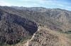
The rocks have been carved into narrow wedges in the Forbidding Canyon. It didn’t really look all that “forbidding”….with the engine running nicely.<br /><br />It’s amazing how thinly water can slice solid rock. The trick is that the rocks aren't solid. They’re fractured. Give water room to get into a small crack, and it’ll make a larger one.<br />
| | Attachments:
Nicely Sliced
| | |
|
Dan Nickens - Nov 10,2011
Viewers
| Reply
|
| |
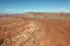
There isn’t much meat left on the Nasja Mesa to keep the river going crooked. U turns in the river are pretty radical. It’s possible that if the dam wasn’t built and the ground didn’t rise up, the river would scour through the narrow land bridge in my lifetime. Now, I’m not so hopeful.<br /><br />Nasja means “owls” in Navajo. I’m sure there must have been owls out there somewhere, but the pickin’s looked pretty thin for the winged predators.<br />
| | Attachments:

Last Strand
| | |
|
Dan Nickens - Nov 10,2011
Viewers
| Reply
|
| |
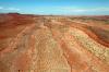
Once there was a ridge and the left bank was connected to the right bank. The river cut right through the rocky ledge, leaving a sharp point.
| | Attachments:
Rock Breach
| | |
|
Dan Nickens - Nov 10,2011
Viewers
| Reply
|
| |
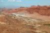
Who’s point: river or rock? The rock makes a point as sharp as the prow on a fast ship. The river cut right through it, proving that water rules the rock. It’s like the rock, scissor paper game on a geologic scale. “Rock, river, rat” might make for a more philosophically challenging roshambo.
| | Attachments:
Making a Point
| | |
|
Dan Nickens - Nov 10,2011
Viewers
| Reply
|
| |
“Sometimes you just gotta take a water break.” It looked as if the river had provided a beautifully formed runway. I did a quick ETA estimate using an approximation of the SeaRey Martial Harmony Balancing Equation. (The GPS can be a great crutch for higher mathematics.) I had to pass as my RQ was forced to rapidly rise as the afternoon waned.
| | Attachments:
SeaRey Splashway
| | |
|
Dan Nickens - Nov 10,2011
Viewers
| Reply
|
| |
With the wind blocked, the water calm, the rocks can bask in their reflections. In a physics class the scene would be classified as a case of specular reflection. In the real world this is a case of spectacular reflection.
| | Attachments:
Rock Reflected
| | |
|
Dan Nickens - Nov 10,2011
Viewers
| Reply
|
| |
Right around the corner from the spectacular reflection, the wind was ruffling the water enough to diffuse the reflected light. It was perfect for SeaRey exploration. There was even a nice beach available. It looked a bit rocky on shore, but a beautiful beach anyway.<br /><br />That caused a bit of dilemma. Sure, the RQ was high, but there was a competing mission: Adam wanted photographs of the SeaRey in spectacular settings. That was a condition precedent for my use of Pia. And the image of reflected cliffs behind a SeaRey was just too good to ignore.<br /><br />I figured Ann would understand it was a reasonable cost to pay for flying someone else’s airplane. After all, she’s a successful woman of business. And understanding (or at least tolerant) of a spouse specializing in monkey business.<br /><br />I only realized how lame my excuse was when I discovered that the wind had blown away the reflection after I got Pia parked.<br />
| | Attachments:
Rock Beach
| | |
|
Dan Nickens - Nov 10,2011
Viewers
| Reply
|
| |
On most beaches the squeaking of sand under bare toes is a prime attraction. Not this one. After losing my excuse for being there, I didn’t stay long.
| | Attachments:
Hard Shoe Beach
| | |
|
Dan Nickens - Nov 10,2011
Viewers
| Reply
|
| |
“This is just impossible to be!” I thought. Ragged and jagged. How can the sharp edges of the rocks be so exquisitely embraced by the smoothness of water? Extreme fluidity joined together with twisted <br />rigidity in a geological dance of spectacular beauty. <br /><br />“The world sure has got a lot weird things.”<br /><br />That’s when it hit me: Randee of the Redwoods was right! In the early days of MTV he sang, “If the facts don’t match the scene, relax and sing, ‘Either way its fine with me, what you’re seeing is impossible to be.’ It’s my motto and it gets me out of a lot of mental jams.”<br /><br />If you don’t know about Randee, his video is preserved for posterity on <br />YouTube: <a href="http://www.youtube.com/watch?v=iHVgEL-fjVc">http://www.youtube.com/watch?v=iHVgEL-fjVc</a><br /><br />It’s true, “Randee should have headed the advice when they said ‘don’t take the brown acid at Woodstock.’” Sadly, I can really understand his Dairy Queen story. And, it’s also true, “We go up we go down we go right we go left, either way it’s alright with me”.<br /><br />
| | Attachments:

Impossible to Be Video
| |
| Attachments:
Jagged Break
| | |
|
Dan Nickens - Nov 10,2011
Viewers
| Reply
|
| |
On top of the flat mesa (or possibly plateau, depending on how long it took me to cross) it wasn’t so flat. In name it was a valley, striped with rocky lines. The floor was mostly made of Cutler Red siltstone mixed with sands brought in from intermittent streams (sediments eroded from the ancestral Rocky Mountains). After deposition the valley (mesa or plateau) was raised up and eroded. <br /><br />The blue green rocks contain manganese oxide. The red rocks contain iron oxide. It’s all about oxides in desert paints.<br />
| | Attachments:
Rock Lines
| | |
|
Dan Nickens - Nov 10,2011
Viewers
| Reply
|
| |
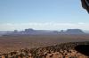
In the event of an unexpected landing it would be prudent to make a sharp turn and land in the lines. I’d hate to mess up the lines or have them mess up Pia.<br /><br />The great valley is part of the 16 million acre Navajo Nation. Monument Valley is protected as a “Tribal Park.”<br />
| | Attachments:
Crossing the Lines
| | |
|
Dan Nickens - Nov 10,2011
Viewers
| Reply
|
| |
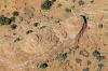
Some horses are just not the kind to stay in a corral. Some of the Indian ponies in the Navajo Indian Reservation don’t take kindly to being fenced in. Approximately 300,000 people live in the Navajo Nation. I couldn’t count all of the ponies.
| | Attachments:
Almost Corralled
| | |
|
Dan Nickens - Nov 10,2011
Viewers
| Reply
|
| |
The big monuments in the valley were just a few minutes deviation from my course line. I was naturally inclined to visit. I checked the clock. I was running seriously behind schedule. I checked the RQ (still high). And worse, there were tall storm clouds visible to the east. I kept to the straight and narrow course line. I always say there is nothing like the fear of death to keep one on a straight and narrow path.
| | Attachments:
Distant Monuments
| | |
|
Dan Nickens - Nov 10,2011
Viewers
| Reply
|
| |
“The world sure has a lot of weird stuff.”<br /><br />Very true. How about siltstone that looks like the thick blobs of mud they come from? You don’t have to be smart to be a rockologist.<br />
| | Attachments:
Old Mud Mounds
| | |
|
Dan Nickens - Nov 10,2011
Viewers
| Reply
|
| |
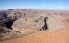
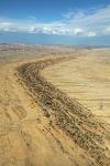
There are a lot of tightly wound river canyons in The Goosenecks. Back in the day there was a just a meandering river, placidly wandering around a valley with very low potential energy. Then the river valley got radically lifted up. With lots of potential energy, the San Juan River started cutting straight down. The meanders were fixed in space and time as the water sliced into the rock 1000’ deep. To follow the river would cover five miles in a line measuring only one mile. That would be really cool, but would require an exceptionally low RQ.
| | Attachments:
Radically Rounded
| | |
|
Dan Nickens - Nov 10,2011
Viewers
| Reply
|
| |
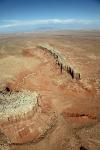
The geology of Raplee Ridge was made by a mad shaman of immense artistic talent. The En Echelon folding gives fine relief within the major geologic structure. The Raplee Ridge is geologically an anticline (sediments folded in a convex upward form) and monocline (single fold). It’s a fold cut in two by the San Juan River. The folding is attributed to an underlying fault by geologists. It’s attributed to peyote fueled dreams by desert wanderers.
| | Attachments:
Giant Zigzags
| | |
|
Dan Nickens - Nov 10,2011
Viewers
| Reply
|
| |
They don’t have geology like this in Florida. To a flatlander, it’s just impossible to be. The Raplee Ridge belongs in a science fiction movie. This is the place where the indigenous morgue monsters rise up from deep cracks to ooze towards the unsuspecting bikini clad co-ed astronaut catching some rays from two suns on a space blanket spread on top of the red mesa.
| | Attachments:
Unearthly Set
| | |
|
Dan Nickens - Nov 10,2011
Viewers
| Reply
|
| |
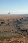
On the backside of the Raplee the ground tries its best to flatten out. Not gonna happen here in this world of weirdness. Comb Ridge is a monocline like Raplee Ridge. The sandstone is tilted at 20 degrees and is exposed along a 120 miles long outcrop.
| | Attachments:
Ridge Back
| | |
|
Dan Nickens - Nov 10,2011
Viewers
| Reply
|
| |
Layer cake geology was what they taught beginners. This must be the cream filling.
| | Attachments:
Cream Filling
| | |
|
Dan Nickens - Nov 10,2011
Viewers
| Reply
|
| |
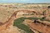
A little water can turn the ground to green. It’s not hard to imagine the “ancient ones” confined to a verdant valley paradise. But it’s not hardly right either.<br /><br />“Twelve thousand years ago when Paleoindian Clovis hunters entered Arizona, there was much more water than today. Well-watered valleys rich in grass and forage were the range for elephants (Mammuthus columbi, or mammoths), horses, camels, bison, and lurking predators such as the dire wolf and the saber-toothed tiger. This prehistoric zoo parade even included a ground sloth that could grow to twelve feet tall but that was, thankfully, a vegetarian. At the end of this geological period that geologists call the Pleistocene, the climate shifted to become more like it is today, the large animals disappeared, and the Clovis hunting culture gave way to sparse populations of Archaic hunting-and-gathering people. “<br />“The Archeology of Ancient Arizona”, by Jefferson Reid; Stephanie M. Whittlesey<br />
| | Attachments:
Little Green Canyon
| | |
|
Dan Nickens - Nov 10,2011
Viewers
| Reply
|
| |
Sticking out from the plains and its parent near Red Mesa, the abandoned long and thin child might be in danger of becoming a butte. It’s hard to imagine a cow happily grazing on its top.
| | Attachments:
Lonely Mesa
| | |
|
Dan Nickens - Nov 10,2011
Viewers
| Reply
|
| |
Simple with no grass to mow. I didn’t see any power lines.
| | Attachments:
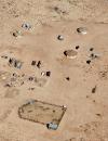
Navajo Village
| | |
|
Dan Nickens - Nov 10,2011
Viewers
| Reply
|
| |
Shiprock showed up on the horizon. In the language of the Navajo, it is TsU Bit'a'í, or 'rock with wings'. I like that a lot better than “Shiprock.” The Rock with Wings is actually the core of an old volcano. With the outside stripped away by erosion, only the inner core remains standing tall.
| | Attachments:
Standup Rock
| | |
|
Dan Nickens - Nov 10,2011
Viewers
| Reply
|
| |
The fields in the San Juan River valley were seriously infected with splotches.
| | Attachments:
Spotted Valley
| | |
|
Dan Nickens - Nov 10,2011
Viewers
| Reply
|
| |
A laid back ridge cut across the flatlands. Coal mines could be seen on both sides of it.
| | Attachments:
Long Ridge Running
| | |
|
Dan Nickens - Nov 10,2011
Viewers
| Reply
|
| |
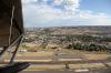
Farmington (KFMN) was my last fuel stop for the day. Looking at the radar made me think maybe it should be the last stop. There were thunderstorms prowling to the east. But they were scattered. And Ann was running later than planned. That lowered my RQ and I figured I could at least try to get around the scattered storms. The rain had already gone east leaving Farmington safely in the dry.<br /><br />The flight from Page to Farmington took a mere 2.6 hours, but it was only 190 miles. Hmmm….okay, so there were several backtracks and some circling, but 73 mph average? Really? The speed-o-meter was showing 95 or more. Except for when it was showing 4 or less when taxiing around on the water. Then there’s the accounting for a lot of WW and SS to account for. I suppose I was lucky to get 73.<br /><br />Then there was camera meter. It was reading another 420 since Page. At over 2 pictures per mile, my card was filling up fast.<br />
| | Attachments:
Leaving Refuge
| | |
|
Dan Nickens - Nov 10,2011
Viewers
| Reply
|
| |
Between the San Juan River, the cliffs and the houses, there was just enough room for a green circle. It just seemed so out of place.
| | Attachments:
Squeezed
| | |
|
Dan Nickens - Nov 10,2011
Viewers
| Reply
|
| |
Normally a nice spot of water would be cause for some SeaRey playtime. The black clouds upstream, however, forced some serious focus on getting somewhere else.
| | Attachments:
No Playtime
| | |
|
Dan Nickens - Nov 10,2011
Viewers
| Reply
|
| |
The hills may be gray, but the stream beds weren’t.
| | Attachments:
Colored Wash
| | |
|
Dan Nickens - Nov 10,2011
Viewers
| Reply
|
| |
The only way through the storms was over the 11000’ hills. The wind was rushing up them. Pia got a free elevator ride upward at 950 fpm. The only thing was that I really hadn’t wanted to climb that high. But, either way was alright with me.
| | Attachments:
Windy Ramp
| | |
|
Dan Nickens - Nov 10,2011
Viewers
| Reply
|
| |
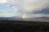
How bad could it be if there is a rainbow in sight? It wasn’t bad. It was like a narrow valley of cloud free air opened up for Pia to fly through. Weird. Very weird.
| | Attachments:
Hopeful Sign
| | |
|
Dan Nickens - Nov 10,2011
Viewers
| Reply
|
| |
At the Rio Grande bridge, Taos airport was almost within reach. The rain was seriously getting close too. The race was on. Pia shifted into turbo mode and dove for our destination.
| | Attachments:

Racing the Rain
| | |
|
Dan Nickens - Nov 10,2011
Viewers
| Reply
|
| |
Say hello to Pia, you good looking asphalt. Over hill and around rain, safe to base. After only 1.8 hours from Farmington, Pia was safely down at Taos Regional (KSKX). Maybe it was only 140 miles in a straight line, but that didn’t include straight up the mountain. And only 62 pictures were shot. That’s more than 2 miles per picture. It’s amazing how bad weather can make you concentrate on flying.<br /><br />Of course Ann was already at the airport, but she hadn’t been there long. The airlines had made my schedule look great in comparison. Excuses could be saved for some other day.<br />
| | Attachments:
Destination Made
| | |
|
Dan Nickens - Nov 10,2011
Viewers
| Reply
|
| |
That speck high up on rock was Ann. At least that’s my recollection. <br />It is impossible to be, though, because Ann has always had a great <br />fear of heights. But, then, she didn’t. Who is that rope wrangling <br />woman?
| | Attachments:
Not Flying
| | |
|
Dan Nickens - Nov 10,2011
Viewers
| Reply
|
| |
Flowers and thunderstorms were blooming in the afternoon sun. It was relaxing to be on the ground contemplating theoretic aerial re-routing.
| | Attachments:
Desert Blooms
| | |
|
Dan Nickens - Nov 10,2011
Viewers
| Reply
|
| |
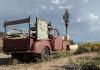
Out in the desert there was a Recycled Subdivision – made of recycled materials. It is off the grid with alternative energy sources. Earth filled tires are used for thermal mass with internal “tin can” walls made of recycled stuff. The only thing out of place was the old gas guzzling pollution producing pickup.
| | Attachments:
Earthship Truck
| | |
|
Dan Nickens - Nov 10,2011
Viewers
| Reply
|
| |
This ain’t your typical suburbs. Hippie houses, I’m guessing.
| | Attachments:
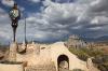
Earthship Houses
| | |
|
Dan Nickens - Nov 10,2011
Viewers
| Reply
|
| |
Up on the mountains, fall was settling in. We found a warm fireplace in an almost deserted ski lodge. Ground truth for flyers can be even better that the higher view.
| | Attachments:
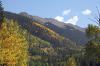
Almost Fall
| | |
|
|
|
|
|
|
|
|
|
|
|
| |
- About Searey.us -
- Contact Searey.us -
|
- Privacy Statement -
- Terms of service -
|
Copyright © 2024 Searey.us & Brevard Web Pro, Inc. -
Copyrights may also be reserved
by posters and used by license on this site. See Terms of Service for more information.
|
| |
- Please visit our NEW
Chapter Place Website at: chapterplace.com or
Free Chapter Management Website at: ourchapter.org. Good for all chapters, groups or families. |
| | | | | | | | | | | | | | | | | | | | | | | | | | | | | | | | | | | | | | | | |