|
|
 |
|
|
|
|
|
|
|
|
|
|
|
|
|

Click on photo to view the original size. |
| Viewers
|
|
|
|
|
|
|
|
|
|
|
Read what others had to say:
|
|
|
|
|
|
|
 |
Dan Nickens - Nov 28,2011
Viewers
| Reply
|
| |
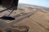
The B-17 wasn’t the only airplane on the ramp ready to launch on a mission. Pia was ready too. I had gotten the call from SeaRey central. “Where are you? When will you be back?” They had reason to have her back sooner rather than later. Sigh. Another mission with a tightened time frame. This time, however, I only offered an ambiguous commitment. “I’ll be back as soon as I can.” There was a lot of scenic territory yet to cover.
| | Attachments:
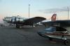
Dawn Patrol Too
| | |
|
Dan Nickens - Nov 28,2011
Viewers
| Reply
|
| |
The colors of dawn nicely highlighted Pia’s gray complexion. Off on the horizon, I could just make out the launching of the festival balloons. Now that would make an early launch all the better. Too bad I had left my cell phone in the rental car. Ann had to reverse course and rush back to Double Eagle before either of us could launch.
| | Attachments:
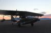
Gray before Dawn
| | |
|
Dan Nickens - Nov 28,2011
Viewers
| Reply
|
| |
The early morning sky was filled with balloons escaping from the festival grounds. The Albuquerque “box” was not in evidence and the balloons were landing in any open field. The box is a unique air circulation that forms a rectangular flow. It allows the balloons to sail away then return to the same spot.
| | Attachments:
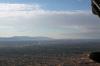
Crowded Sky
| | |
|
Frank A. Carr - Nov 30,2011
Viewers
| Reply
|
| |
At low magnification this looks like you need to clean the canopy. :-)
| | |
|
Dan Nickens - Nov 28,2011
Viewers
| Reply
|
| |
This balloon was going down and south. That’s because the pilot was trying to work the renowned Albuquerque atmospheric box.<br /><br />The “box” is made by a localized temperature inversion and wind shear of 180 degrees. Out in the desert there is a large difference between day and nighttime temperature. Under the clear, low humidity of early October desert nights, cool air flows down from Sandia Mountain. The cool air pools in a layer several hundred feet thick. A cold wind flows to the south downhill along the Rio Grande valley from higher elevations. With the rising sun, the upper atmosphere is heated, creating a temperature inversion (warmer air above the cooler air down low). If the wind is blowing from the south above the basin, there is a complete change in direction with altitude.<br /><br />On a good box day, a balloon can lift off from the park, fly south to the city, light the burner and climb into a northerly wind. Reversing direction the astute weather rider can fly back north past the launching point. Cooling the burner, the balloon magician then sinks back into the lower flow to the south going back where it all started. The cycle can be repeated until the sun burns out the inversion or the wind blows a different direction.<br />
| | Attachments:

Out of Box
| | |
|
Dan Nickens - Nov 28,2011
Viewers
| Reply
|
| |
There were no golfers out in the early morning, but the bright green grass seemed completely out-of-place in the brown desert.
| | Attachments:

Green Space
| | |
|
Dan Nickens - Nov 28,2011
Viewers
| Reply
|
| |
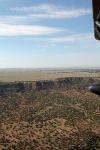
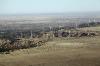
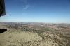
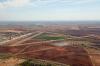
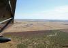
Just on the east side of the mountains there is a great flatness in sharp relief to the mountains. The High Plains, or Llano Estacado (“Palisaded Plain” as described by Francisco Vásquez de Coronado when he first saw it in 1541). It’s not really flat, though. It dips gently from 5000’ in the east to 3000’ on the eastern edge. For an eastbound SeaRey, it was all downhill from here.
| | Attachments:
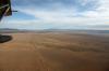
Plenty of Flat
| | |
|
Dan Nickens - Nov 28,2011
Viewers
| Reply
|
| |
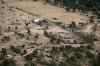
The truck broke down, the shed collapsed, the cows escaped and the house burned (but the trailer didn’t). It could be worse……it could’ve all been in Cleveland.
| | Attachments:
Bad Times
| | |
|
Don Maxwell - Nov 28,2011
Viewers
| Reply
|
| |
Hey! Watch it, Florida Boy. I grew up in Cleveland, when it was "The best location in the nation." ('Course, that <I>was</I> before the Cuyahoga River caught fire.)<!-- >'"><br><font color=red size=6>' or > missing in user HTML. Please fix the HTML.</font> -->
| | |
|
Dan Nickens - Nov 28,2011
Viewers
| Reply
|
| |
Wait, you don't mean the 'mistake by the lake'? But, you are right, Don. I should have said, 'It could be worse...it could've all been in Tampa.' Er, no, then Ken might object. How about: 'It could be worse...it could've all been in Kampala.' (Hopefully there are no SeaRey enthusiasts in Uganda....but, if there are, I'm sorry and I'd really like to come fly with you to correct my bad impression.)
| | |
|
Dan Nickens - Nov 28,2011
Viewers
| Reply
|
| |
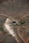
You can lead them to water, but only a cow would drink it. Maybe. If she was desperate.
| | Attachments:
Paths to Water
| | |
|
Dan Nickens - Nov 28,2011
Viewers
| Reply
|
| |
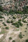
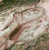
The outlines of an old rock house were just barely visible. They looked just slightly better organized than the natural rocks. Entropy is certainly working at a different pace in the case of the house.
| | Attachments:
Rocks and Ruins
| | |
|
Dan Nickens - Nov 28,2011
Viewers
| Reply
|
Dan Nickens - Nov 28,2011
Viewers
| Reply
|
| |
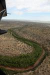
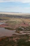
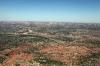
The red Pecos River bed is lined with green running through a desert tan land. It made for colorful viewing.
| | Attachments:
Green Valley
| | |
|
Dan Nickens - Nov 28,2011
Viewers
| Reply
|
| |
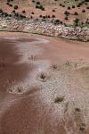
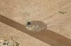
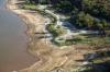
Looking for a splash in a dry country challenges hope for a seaplane pilot. Hope, springs and a shallow draft provided just enough to meet the challenge. A little less water and I’d be sanding scrapes from the bottom of the gray hull. Pia escaped once again with nothing more than a cool hull wash.
| | Attachments:
Shallow Hope
| | |
|
Dan Nickens - Nov 28,2011
Viewers
| Reply
|
| |
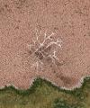
An old tree trunk still sticks above the now dry, cracked mud that enveloped its carcass.
| | Attachments:
Waterless
| | |
|
Dan Nickens - Nov 28,2011
Viewers
| Reply
|
| |
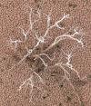
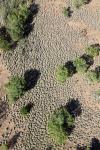
A closer look at the old trunk showed sediment formerly known as mud had cracked up at the base of the once submerged tree. The cracking mud is a good thing. It allows the first water to flow into the aquifer below, eventually swelling shut to pond the water above.
| | Attachments:
Cracked Up
| | |
|
John Robert Dunlop - Nov 28,2011
Viewers
| Reply
|
| |
The magic of static electricity revealed!
| | |
|
Dan Nickens - Nov 28,2011
Viewers
| Reply
|
| |
Hmmm....maybe it was a giant Plasma Ball Globe Sphere Light Dome Orb Lamp that broke, eh?
| | |
|
Dan Nickens - Nov 28,2011
Viewers
| Reply
|
| |
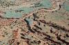
In what had been a small wash, sediments now trapped by the reservoir formed a flat basin bounded by the old valley wall.
| | Attachments:
Flattened Wash
| | |
|
Dan Nickens - Nov 28,2011
Viewers
| Reply
|
| |
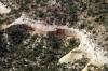
A developing canyon: it’s not so deep now but it has potential. As long at the potential energy supplied by the general uplift in the area persists, it will continue cutting ditches in the dirt.
| | Attachments:
Dissected Dirt
| | |
|
Dan Nickens - Nov 28,2011
Viewers
| Reply
|
| |
A hard layer of flat rock provides the stable platform for a plateau. The sediments were eroded from Version 1.0 of the Rocky Mountains (the “ancestral Rocky Mountains”). They were worn away leaving only a flat sandy plain of covered by slow moving and meandering rivers. Just like the Phoenix, the Rockies rose again and on their flanks they elevated the Llano.<br /><br />The Caprock is a cemented zone of the old river sand (“caliche”). Evaporation and drying at the surface drew mineral laden water into the sand. The minerals cemented the loose soil of the Ogallala Group, forming the “Caprock”.<br />
| | Attachments:
Caprock Flat
| | |
|
Dan Nickens - Nov 28,2011
Viewers
| Reply
|
| |
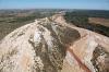
The edge of the Caprock plateau shows its origin in flat bands of old river plain sediments.
| | Attachments:
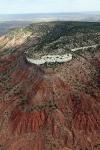
Table s Edge
| | |
|
Dan Nickens - Nov 28,2011
Viewers
| Reply
|
Dan Nickens - Nov 28,2011
Viewers
| Reply
|
| |
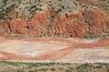
Striped and stained up and down. It was the cause for a brief scenic detour.
| | Attachments:
Striped Cliffs
| | |
|
Dan Nickens - Nov 28,2011
Viewers
| Reply
|
| |
On the edge of the table land there were rows of wind mills. The GPS said the wind crossing the great plain from the south was blowing at 44 mph, at cross purposes to the mission plan, and plenty fast enough to spin the wind mills.
| | Attachments:
Wind Rows
| | |
|
Dan Nickens - Nov 28,2011
Viewers
| Reply
|
| |
The vast Llano looks like a great place to grow grain, but it wasn’t always so. While Coronado described it as a limitless plain of grass, General Marcy said it was shunned by all animals because of the lack of water (1852). In fact there are only two native trees: the tiny shin oak and mesquite.<br /><br />The plateau is elevated not because of uplift (like the Colorado plateau). It is elevated because all the surrounding area was eroded lower. While water works on its shoulders, the caprock defends its top.<br />
| | Attachments:
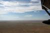
Table Top
| | |
|
Dan Nickens - Nov 28,2011
Viewers
| Reply
|
| |
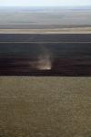
The western part of the Llano plain only gets 13” of precipitation per year. Replacement of drought resistant natural grasses with water sucking crops, aided by over grazing cattle, were the ingredients making for a “dust bow” on the high plateau back in the 1930’s.<br /><br />To grow the current crops, water has to be pumped from an underlying Ogallala (or “High Plains”) aquifer. The aquifer is one of the largest in the world, stretching from South Dakota to New Mexico and Texas. At one time it held more water than all the lakes and streams in the world. That was before pumping. Recharge is about ¾” per year. Pumping has dropped water level in the aquifer at an alarming rate of more than 1’ per year.<br />
| | Attachments:
Dusty Devil
| | |
|
Dan Nickens - Nov 28,2011
Viewers
| Reply
|
| |
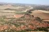
The view below reminded me it was time for lunch. The smell made me think it wouldn’t be a hamburger.<br /><br />Hereford, Texas is the self proclaimed “Beef Capital of the World”. It is also home to the “Angry Herd”. It’s no wonder they’re angry then.<br /><br />Fried chicken was found in Hereford (KHRX) thanks to a crew car (chicken was the natural choice being that the herd was already angry). The 260 mile trip from Albuquerque was done in 3.3 hours. Not bad for such a brisk crosswind. With 326 shots, that was a mere 1.25 photos per mile. There are only so many flatland shots of wheat and cows you can take.<br />
| | Attachments:

Lunch Crowd
| | |
|
Dan Nickens - Nov 28,2011
Viewers
| Reply
|
| |
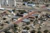
The small plain town had all the ingredients for happiness: plenty of elbow room and no traffic jams. Another important and happy demographic factor: for every 100 females over the age of 18, there were 100 males.<br /><br />Happy got its name from some cow pokes that came across a water hole just as most of their herd was getting very angry and dying of thirst. “Happy Draw” was what they called it. It was later shortened to just plain Happy.<br /><br />Unhappily, population in Happy is decreasing by 10% per year due. Most of the stores were boarded, including the Happy Grain ag store and the Happy Game room. All closed. It’s not due to flat boredom; it’s due to lack of water. There just isn’t enough water left in the aquifer to keep the farms going.<br /><br />The Ogallala aquifer gets pretty thin down near Happy. It is less than 50’ thick. It replenishes very slowly, and with wells pumping since the 1950’s, it’s going dry.<br /><br />The government has stepped in with a water conservation agency. It has already figured out that farming is going to be uneconomical once the Ogallala is dry. Now the government is paying farmers not to grow stuff. That may be economical for the farmers, but not so much for taxpayers.<br /><br />In Texas, a land owner has to the right pump all the water from his land. Famed corporate raider T. Boone Pickens has a plan for dealing with the drought: buy up the land cheap. His company, Mesa Water, began buying up water rights for the Ogallala. With the climate changing, he figures water will someday be more valuable than oil. If so, the thirsty people in Dallas better be saving their money for when his pipeline comes to town. Mr. Pickens has been quoted as saying, “There are people who will buy the water when they need it. And the people who have the water want to sell it. 'That's the blood, guts, and feathers of the thing.”<br /><br />Frankly, I don't see the point to bring birds into his diabolical plan.
| | Attachments:
Happy Town
| | |
|
Dan Nickens - Nov 28,2011
Viewers
| Reply
|
| |
Plowing in arid climates promotes evaporation. A better practice is just to leave the old stalks in place. But, if you’ve got a plow, whatcha gonna do?
| | Attachments:
Making Dust
| | |
|
Dan Nickens - Nov 28,2011
Viewers
| Reply
|
| |
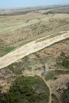
The Prairie Dog Town Fork River cuts away at sediments on the edge of the Llano. Just in front of the wing float is one of the many depressions (or playas) found out on the Llano. The shallow depressions were a meager source of water retention in the semi-arid plain. They were watering holes for migratory fowl and the few critters trying to get by in a dry place. Between the cows and the pumps and the farming, they are a vanishing feature.<br /><br />What rainfall the area does get often accumulates in shallow depressions. There are an estimated 25,000 to 50,000 playas on the Southern Great Plains, most on the Llano. Clay lined, they can hold water for several months after the wet season (spring and early summer).<br /><br />Hydrogeologists found that the playas had a great way of regulating and storing water. Clay in the bottom of the depression held onto water much longer than the surrounding sandy soils. This allowed plants to thrive, providing anchors for the soil when things got dry. The cracks in the mud allowed water to infiltrate when the rain started again until they swelled shut, holding on to the water.<br /><br />The navigation chart showed “numerous” small lakes on the plains. From what I saw, most had been plowed under.<br />
| | Attachments:
Cutting Edge
| | |
|
Dan Nickens - Nov 28,2011
Viewers
| Reply
|
| |
Down where the river has cut away the plains, the underlying sediments are exposed in all their glorious colors.
| | Attachments:
Off the Table
| | |
|
Dan Nickens - Nov 28,2011
Viewers
| Reply
|
| |
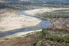
The Prairie Dog Town Fork Red River has a nicely colored sand bed just waiting for some water. The Fork is one of the main tributaries at the head of the Red River.
| | Attachments:
Colored Bed
| | |
|
Dan Nickens - Nov 28,2011
Viewers
| Reply
|
| |
The river had to make a hard right turn when it ran into the rocky red cliff.
| | Attachments:
Right Red Bank
| | |
|
Dan Nickens - Nov 28,2011
Viewers
| Reply
|
| |
Near Childress, the Fork becomes the Red River and spreads out forming the wide Red River valley.
| | Attachments:
Spreading Out
| | |
|
Dan Nickens - Nov 28,2011
Viewers
| Reply
|
| |
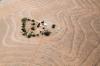
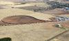
An island in the sea of sand makes a place for one homestead.
| | Attachments:

Island Home
| | |
|
Frank A. Carr - Nov 30,2011
Viewers
| Reply
|
| |
Given the lack of roads or driveway perhaps they commute by Camel?
| | |
|
Don Maxwell - Nov 30,2011
Viewers
| Reply
|
| |
Contour plowing of sand?!!! What's their crop--gravel? Dan, surely there must be some clue just outside the frame.
| | |
|
Dan Nickens - Nov 30,2011
Viewers
| Reply
|
| |
Farming is a magic I’m not privileged to practice, Don. I have no idea what the crop was, but many of the farms have switched from grains to cotton in an effort to minimize water use. And, unfortunately, my camera lens is not wide enough to provide the requested view. The best I can offer is a slightly different angle and a minutely different mix of contrast and color 'enhancement' courtesy of PhotoShop.
| | Attachments:
Island Home2
| | |
|
Dan Nickens - Nov 28,2011
Viewers
| Reply
|
| |
It’s a long way from the high water mark to the water surface and a small distance from the water to the lake bottom. It didn’t seem hardly right to splash any of the little water left. In World War II, bomber trainees practiced their skip bombing techniques on the lake. It was also a bass fishing hot spot. Bet there was more water then.
| | Attachments:
Dam Contours
| | |
|
Dan Nickens - Nov 28,2011
Viewers
| Reply
|
| |
Back during WWII, the Childress Army Airfield hosted students of the bombing arts. A tenth of all U.S. bombardiers in the war perfected their practice at Childress. It was also a prisoner of war camp.
| | Attachments:
Bomber Base
| | |
|
Dan Nickens - Nov 28,2011
Viewers
| Reply
|
| |
At one time you could expect to see waves of grain out on the plains. Now with the water shortage, it’s likely to be waves of cotton.
| | Attachments:

Future Waves of Grain
| | |
|
Dan Nickens - Nov 28,2011
Viewers
| Reply
|
| |
It was the railroad that made Childress. When it came to the county and needed a depot, there were two choices: Childress and Henry. An election was held and Childress won. That didn’t sit well with the right-of-way agent and prominent attorney who favored Henry due to flatter terrain, and the fact that he owned a lot of property there. He went to court and had the election annulled. The next election favored Henry. That didn’t sit well with the proponents of Childress, but a compromise was reached. Everyone in Childress moved to Henry and Henry changed its name to Childress. Done deal.
| | Attachments:
RR Loop
| | |
|
Dan Nickens - Nov 28,2011
Viewers
| Reply
|
| |
Hooking water looks easy, but it’s hard if there isn’t enough to soak the ground.
| | Attachments:
Water Catcher
| | |
|
Dan Nickens - Nov 28,2011
Viewers
| Reply
|
| |
About the only reason to stop at Vernon was to make sure there was fuel enough to get through the rest of the day. Oh, and the fact that Roy Orbison was born in Vernon. Could be why he sang so many sad songs?<br /><br />The Wilbarger airport (F05) is the local airport. Total time enroute was 2.4 hours, over a distance of 180 miles, for a typically average 74 mph. Photos = 152, or only 0.8 photos per mile.<br />
| | Attachments:
Staged Stop
| | |
|
Dan Nickens - Nov 28,2011
Viewers
| Reply
|
| |
The Red River separates Oklahoma from Texas east of Vernon. It’s Oklahoma on the left, and Texas on the right, with the border in the valley between. Reminded me of a country song:<br /><br />“From this valley they say you are going, <br />We will miss your bright eyes and sweet smile, <br />For they say you are taking the sunshine <br />Which has brightened our pathways a while.<br />As you go to your home by the ocean, <br />May you never forget those sweet hours, <br />That we spent in the Red River Valley, <br />And the love we exchanged 'mid the flowers.”<br /><br />So, where are the flowers?<br />
| | Attachments:
Plain Break
| | |
|
Dan Nickens - Nov 28,2011
Viewers
| Reply
|
| |
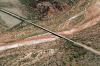
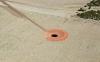
The map clearly showed a power line. A power tower was clearly visible. The lines were invisible. In this case, two out of three sights was scary enough for a dry river running SeaRey. It reminded me of the description of flying in the Hitchhiker’s Guide to the Galaxy by Douglas Adams: “There is an art…or rather a knack to flying. The knack lies in learning how to throw yourself at the ground and miss.” I tried not to throw myself at the unseen wires, but I missed them anyway.
| | Attachments:
Unseen Lines
| | |
|
Dan Nickens - Nov 29,2011
Viewers
| Reply
|
| |
The lines didn't disappear so much as they never appeared at all. It did make me think of illusory effects like disappearing dots.
| | Attachments:

Invisible Dots
| | |
|
Don Maxwell - Nov 29,2011
Viewers
| Reply
|
| |
Wow! That's a terrific illusion! (And I mean terrific in both senses--great and terrifying.) Very instructive for pilots.
| | |
|
John Robert Dunlop - Nov 29,2011
Viewers
| Reply
|
| |
'The knack lies in learning how to throw yourself at the ground and miss.” Brings back memories of a (much) earlier life...<br />I was tasked to do a low level recce ops of several targets in southeastern France including a broadcast tower. I planned the route to do 500 kt. flybys with the appropriate 35mm side camera running. I couldn't see this target coming up (at 8 miles a minute) so on went both sides, front oblique and vertical. Back at the debrief shack my verbal description was somewhat vague until the photo tech brought the long strips of photos. Nothing? Nope. But only the vertical camera caught the tower. Most of the top filled one frame...<br />I still have that photo, …. Somewhere…<br />
| | |
|
Dan Nickens - Nov 29,2011
Viewers
| Reply
|
| |
'knack (n k). n. 1. A clever, expedient way of doing something. 2. A specific talent for something, especially one difficult to explain or teach.' Some of this stuff is just down right spooky, mate. If you ever find that picture, how about sharing it.
| | |
|
John Robert Dunlop - Nov 30,2011
Viewers
| Reply
|
| |
Shure Dan, I looked but most of that stuff is still in boxes from our move..
| | |
|
Dan Nickens - Nov 28,2011
Viewers
| Reply
|
| |
Finally! Water in the river. What a concept!
| | Attachments:
River Stuff
| | |
|
Dan Nickens - Nov 28,2011
Viewers
| Reply
|
| |
With more evidence of water in the river, the vegetation started to get denser. The vegetations got close, but did not quite grow all together.
| | Attachments:
Plotted Plants
| | |
|
Dan Nickens - Nov 28,2011
Viewers
| Reply
|
| |
After miles and miles of a dry to partly moist sandy bed, the Red River started to show some blue water.
| | Attachments:
River Sighting
| | |
|
Dan Nickens - Nov 28,2011
Viewers
| Reply
|
| |
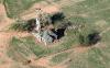
The old homestead is falling to ruin. It’s left the sad stage of drab deterioration and moved on to spooky holiness.
| | Attachments:
Still Standing
| | |
|
Dan Nickens - Nov 28,2011
Viewers
| Reply
|
| |
Not many of the ranch houses looked this nice.
| | Attachments:

Upscale Ranch
| | |
|
Dan Nickens - Nov 28,2011
Viewers
| Reply
|
| |
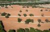
Plenty of trees left in the field. Somebody lined even them up. Nicely planted.
| | Attachments:
Tree Line
| | |
|
Dan Nickens - Nov 28,2011
Viewers
| Reply
|
| |
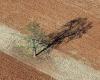
One tree with plenty of lines.
| | Attachments:
Tree Lines
| | |
|
Dan Nickens - Nov 28,2011
Viewers
| Reply
|
| |
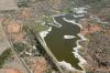
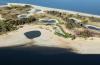
It’s all here: oil wells, cattle, and a little bit of water. In 2007 there was so much water it crested through the emergency spillway. That water was long since gone when I came over.
| | Attachments:
Texas Lakefront
| | |
|
Dan Nickens - Nov 28,2011
Viewers
| Reply
|
| |
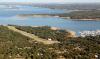
Grass strip, marina and restaurant on a large lake (Lake Texoma). Now that’s prime territory for a gray SeaRey. I decided I'd come back and check it out someday (maybe sooner rather than later?).
| | Attachments:
Nice Arrangement
| | |
|
Mike Purinton - Nov 28,2011
Viewers
| Reply
|
| |
Dan <br /><br /> That picture is of the airport / marina where they hold the lake <br />Texoma splash-in each year in October. I'm 7 miles away at <br />Grayson county airport. If you can get to the splash-in I have <br />a place to put you up.<br /><br /> This year was a banner year for seaplane ops on Lake <br />Texoma. The hot weather raised the temp in the lake to a point <br />where blue/green algae was so prevalent that the lake was <br />closed to swimmers and fishing, so I had the lake to myself. No <br />boat wakes !!!
| | |
|
Dan Nickens - Nov 28,2011
Viewers
| Reply
|
| |
What a great play place you have, Mike. Now if we could get John D. to make an app for the iPad that includes his SeaRey locater map, I'd have known to drop in!
| | |
|
Dan Nickens - Nov 28,2011
Viewers
| Reply
|
| |
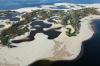
The islands in the lake were in a major growth phase. Drought is good fertilizer for that.
| | Attachments:
Lake Island
| | |
|
Dan Nickens - Nov 28,2011
Viewers
| Reply
|
| |
Low water makes for some pretty nice beaches too.
| | Attachments:
Puzzle Island
| | |
|
Dan Nickens - Nov 28,2011
Viewers
| Reply
|
| |
X marked on the runway was no worry. The main runway may have been closed, but the taxiway was open for business.<br /><br />Only 2.3 hours after leaving Wilbarger, Pia was ready to stop for the night at Durant Regional (KDUA). She was greeted by the local Civil Air Patrollers. They left their meeting to come out and check her out.<br /><br />“How fast is she?” I was asked ten times.<br /><br />“She’s fast enough not to miss many sights.”<br /><br />I could have told them we had just covered 170 miles averaging 75 mph but that just wouldn’t have been the whole story. Maybe visualizing the concept of one photo per mile would have been a better measure of Pia’s capabilities.<br /><br />“Where ya going?”<br /><br />I lied. “Disney World.”<br /><br />“Well, if you had a faster plane, you’d be there now.”<br /><br />“But I’d have missed hours and hours of beautiful things.”<br /><br />“Don’t you like your home?”<br /><br />“I do, but it's even more beautiful after a bit of an absence.”<br /><br />“If you had a woman like mine to come home to, you’d want a rocketship.”<br /><br />“Maybe, but I’ve seen plenty of rockets blow up.”<br /><br />“Must have been a Chinese rocket.”<br /><br />Sometimes there just isn’t any response to give that won’t end in blows. Besides, I didn’t have enough time to explain the relativistic concept of speed of seen. Pia was faster than any jet for close up viewing of lots of scenery worthy of being seen.<br /><br />I didn’t have time because I was headed to the local casino. The Choctaw Nation of Oklahoma operated a casino offering luxury accommodation for a Motel 8 price. But there was no gambling in my nighttime plans. I figured on saving all my luck for the another day’s flight with Pia and heading closer to home. It's hard to hope for being a lot luckier than that.<br />
| | Attachments:
X cluded
| | |
|
|
|
|
|
|
|
|
|
|
|
| |
- About Searey.us -
- Contact Searey.us -
|
- Privacy Statement -
- Terms of service -
|
Copyright © 2024 Searey.us & Brevard Web Pro, Inc. -
Copyrights may also be reserved
by posters and used by license on this site. See Terms of Service for more information.
|
| |
- Please visit our NEW
Chapter Place Website at: chapterplace.com or
Free Chapter Management Website at: ourchapter.org. Good for all chapters, groups or families. |
| | | | | | | | | | | | | | | | | | | | | | | | | | | | | | | | | | | | | | | | | | | | | | | | | | | | | | | | | | | | | | |