|
|
 |
|
|
|
|
|
|
|
|
Posted By:
Hal Brown
Date Posted:
Feb 4, 2012
Description:
It was time to leave. I couldn’t be sure when the celebrity status enjoyed by the SuRi and the SeaRey would end. Getting out on top is always the best.
The SeaRey was not the first seaplane to visit Cabo San Lucas. The very first airplane to arrive was a seaplane belonging to the Mexican Army. It appeared in 1931 when no one in Cabo had ever seen such a thing. The pilot, Feliciano “El Piojo” Flores, flew over, did “loopy loopies” and landed off the beach. With dogs barking, burros baying, church bells ringing and old women fainting, he was welcomed to shore like a sky god. There was a festival and banquet for the decorated medal winner (awarded metals for “extreme valor” and “irreproachable conduct”…..but then there was episode in Mexico City that ended up in 2 weeks of jail time for buzzing the city at 150’ agl). “Shorty” Flores (5’2” tall) danced with the most beautiful women and drank the best wine in Cabo. He left the next day. Shorty retired a Brigadier General in 1967.
Date Taken:
Feb 4, 2012
Place Taken:
North of Cabo San Lucas, Baja California Sur
Owner:
Dan Nickens
File Name:
Going_Norte.jpg - Photo HTML
Full size - <img src="/show.php?splash=SZOIV0000h">
Medium - <img src="/show.php?splash=SZOIV0000m">
Thumbnail - <img src="/show.php?splash=SZOIV0000s">
Category:
497, Yacht Tending Baja
|
|
|
|
|

Click on photo to view the original size. |
| Viewers
|
|
|
|
|
|
|
|
|
|
|
Read what others had to say:
|
|
|
|
|
|
|
 |
Dan Nickens - Feb 04,2012
Viewers
| Reply
|
| |
Given the option, I decided to fly the SeaRey north to its temporary port in Los Angeles. There were a few logistical problems to overcome.<br /><br />The most demanding was finding fuel. Eight hundred miles over a sparsely populated peninsula covered with desert and mountains offered few options. There was a four hundred mile gap in gas stations.<br /><br />“No problemo, Señor, we weel geet de gas.” <br /> <br />It’s good to have friends. Sebastian called the General who called the Colonel who called the Captain who commanded the military operation at an airport half way up the peninsula.<br /><br />“You can geet de gas, but no with cash. The Army cannot take de cash.” I paid Sebastian who traded fuel for the next military flight to visit his airport.<br /><br />He actually did the same thing for the helicopter. Only the General forgot to call and the helicopter was detained for hours waiting until all the approvals could be obtained.<br />“For you, my friend, I weel call the Captain before you leave and I give you two copies of the letter showing eets okay.”<br /><br />Great! What’s the worst that could happen? A few extra hours in Mexico?<br /><br />Then there was the weather to consider. It was clear and beautiful, except for the probability of notoriously strong winds in the mountains and fog that frequented the low lying military gas base in the morning and evening.<br /><br />Well, the good thing about an amphibian is that you have options, even if they involve spending the night in the middle of nowhere.<br />
| | |
|
Dan Nickens - Feb 04,2012
Viewers
| Reply
|
| |
The path north to the first fuel stop meant crossing from the Pacific side to the Gulf. The main road went through a gap in the mountains towards La Paz across the Magdalena Plain. The plain is an old, mostly flat erosion surface from a higher sea level back when the dinosaurs were free range. The plain is now slightly tilted and I followed the road across it.<br /><br />A dry wash offered a bit of a diversion. It was easy to imagine the torrents that fill it during the rare summer rainstorm or the early fall chabascos (hurricanes). There was no water and little time for scenic diversions. I got a very late start waiting for paperwork. The evening fog don’t care about no paperwork.<br />
| | Attachments:
Crossing Over
| | |
|
Frank A. Carr - Feb 04,2012
Viewers
| Reply
|
| |
No Plan B in sight.
| | |
|
Dan Nickens - Feb 04,2012
Viewers
| Reply
|
| |
Plan B was the deserted road. Plan C was the wash. Plan A was not to crash. In case of fog at my destination, Plan Z was spending the night in the airplane. (I'm not saying they were good plans!)
| | |
|
Dan Nickens - Feb 04,2012
Viewers
| Reply
|
| |
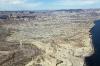
Out in the middle of the desert sat a huge expanse of greenhouses. A small community occupied one corner. Water comes from an aquifer with “fossil water” that is not being replenished. The rainfall runs off quickly and doesn’t do much to fill the old aquifer. One can hope they finish the roof on the church before the wells run dry.
| | Attachments:
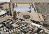
Desert Development
| | |
|
Dan Nickens - Feb 04,2012
Viewers
| Reply
|
| |
This is what happens when the well runs dry. It’s as Porfirio DiUz once said, “Poor Mexico! So far from God and so close to the United States.”
| | Attachments:

Dry Well
| | |
|
Frank A. Carr - Feb 04,2012
Viewers
| Reply
|
| |
'One man's junk is another man's ....'
| | |
|
Dan Nickens - Feb 04,2012
Viewers
| Reply
|
Dan Nickens - Feb 04,2012
Viewers
| Reply
|
| |
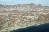
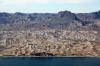
La Paz was the first place settled by the Spanish on the Baja. It has a beautifully protected harbor, Bahia De La Paz, the largest bay on the east coast of the peninsula. The muddy sand spit, El Magote, was deposited by southerly currents on the western side of the gulf.<br /><br />When CortUs, conqueror of Mexico, first landed at La Paz he thought it was an island. He claimed the Island of California by walking around whacking cactus with his sword. Maybe he proclaimed, “It’s a worthless sheep that can’t carry its own wool.” (That’s how he scolded his soldiers.)<br /><br />In 1535 the settlement of La Paz was supposed to be his crowning achievement. Instead, as written in Diaz’s “True History”, “Of the soldiers that were with, CortUs twenty-three died from hunger and illness and many others were ill, and they cursed CortUs, his island, his bay, and his discovery.”<br /><br />Apparently he didn’t pay any attention to the ugly blackened little nubs the Indians traded. Only later was it figured out that these were pearls from oyster shells pulled from the bay and thrown into fires to open up. Once the Spaniards used their thin knives to open the shells, they found real treasure. It was the pearls that led to a permanent settlement at La Paz after a hurricane blew a massive number of shells ashore. La Paz became the chief producer of pearls by the early 20th century. Over fishing and disease eventually wiped out the pearl farmers.<br />
| | Attachments:
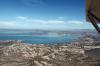
First City
| | |
|
Dan Nickens - Feb 04,2012
Viewers
| Reply
|
| |
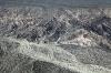
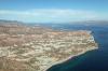
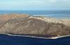
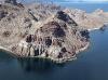
The flat plain hosting La Paz ends suddenly at the hills. The Gulf Scarp is comprised of the Comondu Formation, volcaniclastic sandstones that are highly faulted and tilted. The whole area is part of the east Pacific rise. The rise separates the Pacific plate from the North American plate. The mountains and basins were lifted or dropped in the rising. Plates spreading away from the rise opened the great gap that produced the Gulf of California during Cenozoic time.
| | Attachments:
Heading for the Hills
| | |
|
Dan Nickens - Feb 04,2012
Viewers
| Reply
|
| |
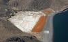
There were big dunes along the coast, but only a narrow beach where sea scour overwhelms the gravity of deposition.
| | Attachments:

Big Dunes
| | |
|
Dan Nickens - Feb 04,2012
Viewers
| Reply
|
| |
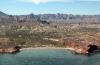
The soft hills are spectacularly eroded around the coast.
| | Attachments:
Tough Terrain
| | |
|
Dan Nickens - Feb 04,2012
Viewers
| Reply
|
| |
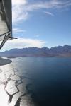
Sediments deposited in nicely ordered layers tumble down to the sea in a beautiful mottled mess. The Isidro Formation is composed of greenish, whitish, and yellowish sandstones interbedded with greenish shales. It is all overlain by 22 million year old volcanic tuff on top of the hills.
| | Attachments:
Mottled Lines
| | |
|
Dan Nickens - Feb 04,2012
Viewers
| Reply
|
| |
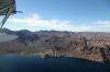
The island looked alluring. Unfortunately time and fuel kept me from crossing over.
| | Attachments:
Point of No Departure
| | |
|
Dan Nickens - Feb 04,2012
Viewers
| Reply
|
| |
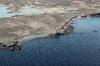
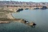
On a craggy coast, any indent of sailboat size makes a nice harbor.
| | Attachments:

Protected Parking
| | |
|
Dan Nickens - Feb 04,2012
Viewers
| Reply
|
| |
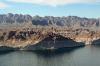
This protected bay was a bit too shallow for sailboat use.
| | Attachments:
Salty Spot
| | |
|
Dan Nickens - Feb 04,2012
Viewers
| Reply
|
| |
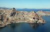
Plenty of vacant coast is still available for future high rise condos.
| | Attachments:
Awaiting Developments
| | |
|
Dan Nickens - Feb 04,2012
Viewers
| Reply
|
| |
The cutoff lagoon on the island looked perfect for SeaRey splashing, but so did the calm Gulf. So many temptations weighed against a too early fog.
| | Attachments:
SeaRey Suitable
| | |
|
Dan Nickens - Feb 04,2012
Viewers
| Reply
|
| |
The rapidly rising terrain made a beautiful barrier to an inland route. The escarpment is an exclamation drawn along the eastern side of the Sierra la Giganta. The flat strata extends across the peninsula into the Pacific Ocean. It is only in the fault zone where the layers become deformed and chaotic.
| | Attachments:
Coastal Cliffs
| | |
|
Dan Nickens - Feb 04,2012
Viewers
| Reply
|
| |
So many immediate options to explore, too much worry about the future!
| | Attachments:
Beaching Options
| | |
|
Dan Nickens - Feb 04,2012
Viewers
| Reply
|
| |
With so many opportunities for delay, there was good cause to re-evaluate my options. Maybe I could just stop in Loreto for the night. No fog there. But my fueling was pre-arranged for another place and time. And then there was the U.S. Government ePiss Application for Readmission to the Fatherland filed with the Royal Border Guards mandating a date and time certain. <br /><br />Sigh. I flew on.<br />
| | Attachments:
More Beaching Passed
| | |
|
Dan Nickens - Feb 04,2012
Viewers
| Reply
|
| |
Here’s another SeaRey affliction for me: beaches out of time. It’s torture to fly over so many beaching opportunities.
| | Attachments:
No Time for Beaches
| | |
|
Dan Nickens - Feb 04,2012
Viewers
| Reply
|
| |
If beaches aren’t your thing, cliffs abound along the coast.
| | Attachments:
Sea Cliffs
| | |
|
Dan Nickens - Feb 04,2012
Viewers
| Reply
|
| |
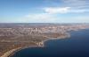
Miles and miles of spectacular mountains, beaches and water without a trace of human habitation!<br /><br />Unbelievable.<br /><br />It was also cause for pause. There was plenty of empty space and no possibility of a quick rescue if things turned bad. I was told that the Mexican flight plans were for informational purposes only. If you didn’t show up as planned, calls might be made to intermediate airports to see if you landed someplace.<br /><br />“Well, what if I'm not at an airport?”<br /><br />“No lo se. I don’t know. The form is filed. Who knows?”<br /><br />Great. I checked my personal locater beacon just in case. The emergency provisions of water and granola bars looked pretty meager for being such a long way out of the way.<br />
| | Attachments:
Terrific Topography
| | |
|
Dan Nickens - Feb 04,2012
Viewers
| Reply
|
| |
The land and sea were beautiful, but maybe it wouldn’t be so scenic if you had to cross it on foot instead of on a magic carpet. Then I recalled what Charles A. Lindbergh had said: “Whether outwardly or inwardly, whether in space or time, the farther we penetrate the unknown, the vaster and more marvelous it becomes.” <br /><br />Yep. I can confirm that.<br />
| | Attachments:
Vaster Topography
| | |
|
Dan Nickens - Feb 04,2012
Viewers
| Reply
|
| |
With the afternoon rapidly flying past and the water lying flat, there was no need to hug the security of the coast line. Offshore there were islands, rocky “stacks” composed of volcanic breccias, liberally dissected by dikes and faults. Going direct meant passing them by.<br /><br />“Maldiciones. ¡Frustrado otra vez!” (Curses. Foiled again!)
| | Attachments:
Direct Routing
| | |
|
Dan Nickens - Feb 04,2012
Viewers
| Reply
|
| |
Intricate patterns on the water and in the sky negated any possibility of boredom.
| | Attachments:
Patterns Up and Down
| | |
|
Dan Nickens - Feb 04,2012
Viewers
| Reply
|
Dan Nickens - Feb 04,2012
Viewers
| Reply
|
| |
It was a disappointment and relief to end up on a final approach concluding the southern quarter of the peninsula.
| | Attachments:

Approach Path
| | |
|
Dan Nickens - Feb 04,2012
Viewers
| Reply
|
| |
As requested, a stylized map showing too many straight lines to accurately depict a 2.8 hour erratic SeaRey kinda course.
| | Attachments:
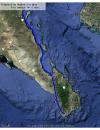
msl2mlt
| | |
|
Kenneth Leonard - Feb 04,2012
Viewers
| Reply
|
| |
So, DID you end up using the 'spend the night in the middle of nowhere' option?<br />I slept in the back of a 172 on a cold night once - learned that lesson.
| | |
|
Dan Nickens - Feb 05,2012
Viewers
| Reply
|
| |
Now, Ken, no fair peeking ahead, but what was so bad about the Cessna's back seat? I don't remember ever being back there. Isn't that where the luggage goes?
| | |
|
|
|
| |
- About Searey.us -
- Contact Searey.us -
|
- Privacy Statement -
- Terms of service -
|
Copyright © 2024 Searey.us & Brevard Web Pro, Inc. -
Copyrights may also be reserved
by posters and used by license on this site. See Terms of Service for more information.
|
| |
- Please visit our NEW
Chapter Place Website at: chapterplace.com or
Free Chapter Management Website at: ourchapter.org. Good for all chapters, groups or families. |
| | | | | | | | | | | | | | | | | | | | | | | | | | | | | | | |