|
|
 |
|
|
|
|
|
|
|
|
Posted By:
Hal Brown
Date Posted:
Mar 11, 2012
Description:
There were lots of safety concerns being in a border town. The drug and kidnapping problem in Mexicali was in my morning newspaper at the hotel. Then I read about the most dangerous river in American just outside the airport. But, as it turned out, that wasn’t the scariest thing about the Calexico airport.
The All American Canal takes water from the Colorado River and distributes it to the Imperial Valley. The 80 mile long canal is said to be largest aqueduct in the world.
It is also said to be the most dangerous “river” in the U.S. More than 500 people, mostly illegal immigrants, have drowned in its swift moving waters.
The scariest thing to me about the Calexico airport, though, was the dog pound. Their plaintive howls haunted me as I prepared the airplane for departure. And that was before I spotted one of their emaciated brothers staggering along in the shade of the border fence.
How is it possible that an aerial port to freedom is occupied by imprisoned creatures? Is it fair that I was flying off to a spectacular day as they began their daily life in such horror? I was so upset by the sounds and sight that I didn’t even consider getting the hull wet in the canal.
Date Taken:
Mar 11, 2012
Place Taken:
All American Canal, Calexico, CA
Owner:
Dan Nickens
File Name:
Outta_Calexico.jpg - Photo HTML
Full size - <img src="/show.php?splash=SZOHK0000h">
Medium - <img src="/show.php?splash=SZOHK0000m">
Thumbnail - <img src="/show.php?splash=SZOHK0000s">
Category:
497, Yacht Tending Baja
|
|
|
|
|

Click on photo to view the original size. |
| Viewers
|
|
|
|
|
|
|
|
|
|
|
Read what others had to say:
|
|
|
|
|
|
|
 |
Dan Nickens - Mar 11,2012
Viewers
| Reply
|
| |
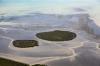
The desert appeared quickly when the canal turned away. The Yuha Desert is part of the greater Sonoran Desert occupying a large portion of southwestern Arizona and southern California.<br /><br />The desert is also part of the Fort Yuma Indian Reservation. It is an area of “Critical Environmental Concern” not because it is the homeland of the Quechari people, but because of the flat tailed horned lizard.<br /><br />I can see that. My childhood sympathies stem from remembering Yosemite Sam yell “Great Horny Toads!” whenever there was an unexpected development on Saturday cartoons. Those desert toads and lizards should be saved!<br />
| | Attachments:
Not Yet Farmed
| | |
|
Dan Nickens - Mar 11,2012
Viewers
| Reply
|
| |
Splotches of color appeared intermittently among the darker browns of the desert floor as if some giant had dropped tanker loads of paint. Some might think it’s simply weathering of sandstone containing iron, sulfur and copper surrounded by a volcanic matrix.<br /><br />Local Native Americans, the Cahuillas, had a different theory. The red splotches are blood from the creator of the world. The people he made killed him after he invented rattlesnakes to keep the land from being overpopulated. They set about to cremate his dead carcass. The Creator’s son, a coyote, jumped into the fire and pulled his dad’s heart out. The son occasionally dropped the bloody organ as he tried to run away with it.<br /><br />And that’s the story that makes the most sense to me. Isn’t it just like people to kill their maker.<br />
| | Attachments:
Paint Spill
| | |
|
Dan Nickens - Mar 11,2012
Viewers
| Reply
|
| |
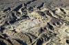
Back before the Peninsular Ranges and the Colorado River delta isolated the upper portion of the Salton Sink it was open to the Sea of Cortez. After it was cut off from the sea, a great grassy plain evolved in a cooler, wetter climate. A menagerie of great creatures soon populated the lush plain: mastodons, sabre-tooth tigers, camels, and zebras (not to mention a couple of bad dogs: the bone-crunching dog and the Dire Wolf, and definitely not discussing a condor with a 17’ wing span).<br /><br />But then the coastal mountains grew up and the grass faded to desert in their rain shadow. (The mountains capture 30” of precipitation per year. Only about 3” make it out to the desert.) Or maybe the climate changed due to the demise of the Little Ice Age. Or maybe grazing cows and sheep ate all the grass. Or maybe all or none of the above?<br />
| | Attachments:
Desert Flows
| | |
|
Dan Nickens - Mar 11,2012
Viewers
| Reply
|
| |
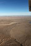
How does land turn into badlands? Soft sediments that once lay on the ocean floor got pushed up along with the Peninsular Ranges to the west. Rain and snow melt from the mountains rapidly flowed through the rising soft mud and sand, cutting deep gouges as it raced to the Salton Sea.
| | Attachments:

Sharp Ground
| | |
|
Dan Nickens - Mar 11,2012
Viewers
| Reply
|
| |
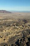
Not every place is dissected. Some rocks, usually of a volcanic persuasion, are just too hard to be carved up so easily.
| | Attachments:
Flat Spots
| | |
|
Dan Nickens - Mar 11,2012
Viewers
| Reply
|
| |
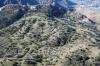
Leaving the desert for the mountains, things got decidedly greener. Most of the La Jolla Indian Reservation burned in 2007. It looks nicely verdant now.
| | Attachments:
Mountain Meadows
| | |
|
Dan Nickens - Mar 11,2012
Viewers
| Reply
|
| |
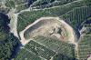
Could a California orange grove work for SeaReys like my home grove? Maybe, but I’d want a bigger pond with a bit more water. And it could use some mowing too.
| | Attachments:
High Orchards
| | |
|
Dan Nickens - Mar 11,2012
Viewers
| Reply
|
| |
Getting the fruit picked and down to market from the hills looks to be challenging. Donkeys have been used with good success. They can carry up to 100 pounds and aren’t intimidated by the slopes. Another good thing: they don’t eat avocados. As an alternative, growers can use a “fruit chute” made of canvas on a light steel frame with baffles to slow the fruit's downhill slide. A variation on the chute is a plastic, inflatable tube. Fruit is dropped in then the chute is wenched up to a waiting jeep. Then there was one experiment with a helicopter that scooped up 700 pounds of the tasty treats from the hillside. Sounds a bit expensive. But even more exotically, someone even suggested a monorail (probably an elevated train salesman).
| | Attachments:

Tall Terraces
| | |
|
Dan Nickens - Mar 11,2012
Viewers
| Reply
|
| |
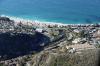
Laguna has long been the inspiration for a community of artists founded in landscapes. The countryside was once described 'as a child of that deathless search, particularly by persons who devote their lives to painting or writing, for some place where beauty and cheapness and a trifle of remoteness hobnob together in a delightful companionship.' I can’t comment on the cheapness, but beauty splashed with some trifling certainly fits.
| | Attachments:
Out to the Ocean
| | |
|
Dan Nickens - Mar 11,2012
Viewers
| Reply
|
| |
Just off shore the water was boiling. Closer inspection found a stampeding pod of porpoise. It even made the news when a whale watching boat spotted the same thing.
| | Attachments:

Wet Purpose Link
| |
| Attachments:

Herding Porpoise
| | |
|
Dan Nickens - Mar 11,2012
Viewers
| Reply
|
| |
It is hard to stop a moving porpoise from a flying SeaRey. I couldn’t.
| | Attachments:

Hard to Catch
| | |
|
Dan Nickens - Mar 11,2012
Viewers
| Reply
|
| |
Flowing down from the San Bernardino Mountains, the Santa Ana River is the largest river in southern California. The river has been diverted for groundwater recharge so not much reaches the ocean these days.<br /><br />In the 1940’s the Corpse of Engineers decided it was the most dangerous river west of the Mississippi due to a propensity to flood outside its nominal bounds. The Corpse Oh Engineers built a dam to stop that nonsense. In 1989 work began to convert the river into a giant concrete culvert. With the addition of another dam in 1999, the river is now declared safe for a 350 year flood event by officers and prognosticators of the CoE. <br />
| | Attachments:
Concrete River
| | |
|
Don Maxwell - Mar 11,2012
Viewers
| Reply
|
| |
Tsk!
| | |
|
Dan Nickens - Mar 11,2012
Viewers
| Reply
|
| |
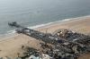
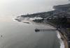
The pier is designed to withstand 30 foot waves. There were no worries on this day. The sea was calm enough for some SeaRey splashing. That may have provided a bit of entertainment for beachcam viewers.
| | Attachments:

Beachcam
| |
| Attachments:
Pacific Calm
| | |
|
Dan Nickens - Mar 11,2012
Viewers
| Reply
|
| |
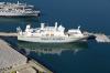
The Queen Mary may still look like a ship, but the Coast Guard decided it is actually a building. That ruling meant that the land-based unions could work on it instead of the maritime unions. I had no idea that unified organizations fought over such distinctions. I suppose I shouldn't be surprised.
| | Attachments:
Port Parking
| | |
|
Dan Nickens - Mar 11,2012
Viewers
| Reply
|
| |
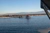
Long Beach is the home port of a floating space launch system. It consists of the Assembly and Control Ship (photo) and a semi-submersible oil platform converted to launch rockets from an optimum position along the equator. The launch company declared bankruptcy in 2009 when it proved not be so optimum in an economic sense. A year later it emerged with a new Russian company as owner.
| | Attachments:
Star Ship
| | |
|
Bård Sørbye - Mar 17,2012
Viewers
| Reply
|
| |
Infamous Norwegian project. One of my fellow local pilots works in the company that designed it. I recently wondered what had become of it. Now I know.
| | |
|
Dan Nickens - Mar 11,2012
Viewers
| Reply
|
| |
In 1909 the justification for building a long, narrow pier on the beach at Santa Monica was to extend the sewer outlet past the breakwaters. Hopefully they’ve come up with other good reasons since then.
| | Attachments:
Pier Park
| | |
|
Dan Nickens - Mar 11,2012
Viewers
| Reply
|
| |
The famous “Surfrider” beach was a focal point of the early surfing culture and 1960’s movies. In 2010 it was declared the world’s first “World Surfing Reserve”, whatever that means.
| | Attachments:
Malibu Point
| | |
|
Dan Nickens - Mar 11,2012
Viewers
| Reply
|
| |
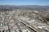
Los Angeles County had a population of almost 10 million people in 2010 according to government census takers. The major population center sits atop a sedimentary basin six miles deep surrounded by the Peninsular and Traverse Mountain ranges. The basin sediments trapped enough oil for several good oil fields (Huntington Beach, Torrance, Beverly Hills and Los Angeles City). Exhaust from cars scooting around the basin put out enough ozone pollution to make it the worst in the nation.
| | Attachments:
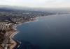
LA Haze
| | |
|
Dan Nickens - Mar 11,2012
Viewers
| Reply
|
| |
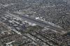
Unbeknownst to most of the airline transients below, there is a flight corridor right over LAX for little planes. It is possible to cross over the busy airport at 3500’ or 4500’ agl without ever talking to anyone on the ground. It wasn’t my first choice: I requested the helicopter route running just offshore. At first the local traffic controller thought it would be okay, but he was over ruled by a picky supervisor who decided the SeaRey wasn’t sufficiently helicopter-like to qualify.
| | Attachments:
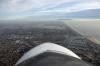
Crossing LAX
| | |
|
Frank A. Carr - Mar 14,2012
Viewers
| Reply
|
| |
Dan, if memory serves me correctly (an often faulty assumption), it was in the mid-to late 80's that the well known pilot and author, Barry Schiff, started a campaign on behalf of VFR fliers in the LA Basin. His point was that FAA charts (eg, LAX Terminal) gave lots of information dealing with where pilots CANNOT fly, but no charts provided guidance as to where you could fly. He began an effort to chart several VFR Flyways in and around the LA area and the LAX Corridor ultimately came out of his efforts. There were (maybe still are?) others leading into and around the Basin.BTW readers of Barry's AOPA column will know that he has retired from TWA, lives in CA, and is trying to accumulate flights in a large number of different airplanes; I emailed him a year ago suggesting he add the SeaRey but an invitation from PA might be welcome. http://www.barryschiff.com/<!-- >'"><br><font color=red size=6>' or > missing in user HTML. Please fix the HTML.</font> -->
| | |
|
Dan Nickens - Mar 11,2012
Viewers
| Reply
|
| |
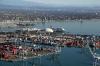
With 61 million passengers passing through, Los Angeles International Airport qualifies as the fifth busiest in the world.
| | Attachments:
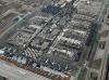
Lots of Heavy Metal
| | |
|
Dan Nickens - Mar 11,2012
Viewers
| Reply
|
| |
Just north of LAX was the SeaRey’s new home. The Santa Monica airport was originally a field used by barnstormers back in 1919. In 1922 the Douglas Aircraft Company started using it to test production aircraft. DC-3/5/6/&7 airliners started life here. To accommodate 44,000 workers, houses were built right up to the airport boundary. That might have been a mistake.<br /><br />In the 1950’s Douglas went to the town with a plan to extend the runway for its new jets. The town said no and aircraft production was moved to Long Beach. When corporate jets came anyway, the neighbors sued for noise and pollution. The neighbors lost the court battle, but started winning on the local political front.<br /><br />The city tried several times to close the airport. In 1984 the town was forced to enter into an agreement to keep the airport open, but with a whole host of restrictions. The town now happily proclaims it has the most restrictive and punitive noise regulations in the nation. They actually publish a list of banned aircraft types. Oddly, those blacklisted airplanes include B-17s and B-25s, aircraft directly responsible for the neighbors ability to openly complain about their noise. Amazing.<br /><br />Pilots basing at SMO undergo a mandatory indoctrination in airport rules and regulations. After telling you to keep it quiet, the authorities emphasize that there is to be no ogling of stars. Photography is strictly forbidden.<br /><br />That was fine with me, but when I went to move the little SeaRey into its new home I found it surrounded by lots of ooglers. Several had cameras happily snapping away. There is apparently an exception in the airport photography rules for airplane superstars.<br /><br />The SeaRey is housed in a pretty high rent district. Hangar neighbors now include Tom Hanks, Bruce Willis, and Steven Spielberg, with Harrison Ford just around the corner.<br /><br />They will just have to share the spotlight until N415RK gets back to the yachting business. The SeaRey’s boat will be laid up until June with its remodeling. Until then southern California is its playground.<br />
| | Attachments:
SuRi Remodeling
| |
| Attachments:
Douglas Place
| | |
|
Don Maxwell - Mar 11,2012
Viewers
| Reply
|
| |
Astonishing how close to flat that ship's bottom is. How does she do in heavy seas?
| | |
|
Dan Nickens - Mar 11,2012
Viewers
| Reply
|
| |
I can't say, Don, as I've not had that kind of experience onboard but the engineers say she'll take some serious seas.
| | |
|
John Robert Dunlop - Mar 12,2012
Viewers
| Reply
|
| |
Wow! Doesn't look like she'll roll too badly. Are they changing the engines or adding stabilizers?
| | |
|
Dan Nickens - Mar 12,2012
Viewers
| Reply
|
| |
Definitely new engines, John, but the only stabilizer I know of on board is the chief steward.
| | |
|
John Robert Dunlop - Mar 13,2012
Viewers
| Reply
|
| |
:) That big eh?!
| | |
|
Dan Nickens - Mar 11,2012
Viewers
| Reply
|
| |
Running from the border all the way to Los Angeles, I never really left the dogs behind.
| | Attachments:
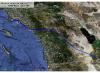
CalexicoToSMO
| | |
|
Russ Garner - Mar 12,2012
Viewers
| Reply
|
| |
My old stumping grounds Dan spent a lot of time Santa Monica. Leno had a hanger there also.
| | |
|
Dan Nickens - Mar 13,2012
Viewers
| Reply
|
| |
Did you ever figure out the boundaries between the runways, taxiways and roads, Russ? It's just like one big paved parking lot!
| | |
|
Russ Garner - Mar 13,2012
Viewers
| Reply
|
| |
It's an interesting place LA Dan it's a busy place though so you need to talk to everyone you can while flying. Pretty ride up the coast to KSBA and the Elephant Bar restaurant if you want to get away from the busy city. Catch the local bus into down town Santa Barbara and spend the day. Fly LA on a clear night if you get the chance.
| | |
|
Frank A. Carr - Mar 14,2012
Viewers
| Reply
|
| |
Rus, how about the beach restaurant (or is it the Elephant Bar now) within walking distance <br />of KSBA? A delightful destination. I've had the chance to do several night-time VFR flights <br />around downtown LA but you had to stay low (oh shucks), and it is awesome.
| | |
|
Russ Garner - Mar 15,2012
Viewers
| Reply
|
| |
Frank, you can just tell the tower that your going to the Elephant Bar it's on the East end of the airport. One of my favorite night flights in the Searey was from KEMT to KSBA for dinner. 805) 964-0779<br />521 Firestone Rd, Santa Barbara, CA 93117<br />Directions|Send to Phone<br /><a href="http://www.elephantbar.com/">www.elephantbar.com</a><br />
| | |
|
|
|
|
|
|
|
|
|
|
| |
- About Searey.us -
- Contact Searey.us -
|
- Privacy Statement -
- Terms of service -
|
Copyright © 2024 Searey.us & Brevard Web Pro, Inc. -
Copyrights may also be reserved
by posters and used by license on this site. See Terms of Service for more information.
|
| |
- Please visit our NEW
Chapter Place Website at: chapterplace.com or
Free Chapter Management Website at: ourchapter.org. Good for all chapters, groups or families. |
| | | | | | | | | | | | | | | | | | | | | | | | | | | | | | | |