|
|
 |
|
|
|
|
|
|
|
|
|
|
|
|
|

Click on photo to view the original size. |
| Viewers
|
|
|
|
|
|
|
|
|
|
|
Read what others had to say:
|
|
|
|
|
|
|
 |
Dan Nickens - May 11,2012
Viewers
| Reply
|
| |
With the weather perfectly positioned to the south, the SeaReys fell right back into position for some serious country crossing.
| | Attachments:
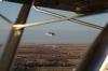
Perfect Position
| | |
|
Dan Nickens - May 11,2012
Viewers
| Reply
|
| |
To get to the western mountains you have to cross the plains.
| | Attachments:
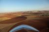
Plain Fields Ahead
| | |
|
Dan Nickens - May 11,2012
Viewers
| Reply
|
Dan Nickens - May 11,2012
Viewers
| Reply
|
| |
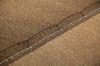
A giant illustration of the point of thirds.
| | Attachments:

Pie Chart
| | |
|
Dan Nickens - May 11,2012
Viewers
| Reply
|
Russ Garner - May 11,2012
Viewers
| Reply
|
| |
IFR...
| | |
|
Dan Nickens - May 11,2012
Viewers
| Reply
|
| |
Water is a scarce commodity out on the plains….except it just rained yesterday! Sprinkling so soon? Seriously?
| | Attachments:
Half Wet
| | |
|
Dan Nickens - May 11,2012
Viewers
| Reply
|
| |
I never have to wonder where my wingman is.
| | Attachments:
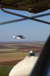
Still There
| | |
|
Dan Nickens - May 11,2012
Viewers
| Reply
|
Dan Nickens - May 11,2012
Viewers
| Reply
|
| |
Great plains eventually end, and this one drops off the edge.
| | Attachments:

Plain Edge
| | |
|
Don Maxwell - May 11,2012
Viewers
| Reply
|
| |
That plain sure has big propellers! I wonder how fast it goes.
| | |
|
Dan Nickens - May 11,2012
Viewers
| Reply
|
Dan Nickens - May 11,2012
Viewers
| Reply
|
| |
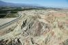
The rock capping the Staked Plains is plenty tough (it’s cemented through years of evaporation and deposition of minerals, forming “caliche”). It’s not tough enough though. Water is nibbling away at the edges.
| | Attachments:

Tough Rock
| | |
|
Dan Nickens - May 11,2012
Viewers
| Reply
|
| |
The caprock fails when it’s undercut by water. It’s falling off the plain in sharp chunks.
| | Attachments:
Sharp Edges
| | |
|
Dan Nickens - May 11,2012
Viewers
| Reply
|
| |
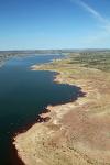
On the edge of the mountains is a reservoir with a seaplane base. That was invitation enough to stop in and check out the water.
| | Attachments:
Plain Lake
| | |
|
Russ Garner - May 11,2012
Viewers
| Reply
|
| |
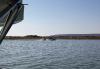
I can hear Richard, Ah something I can land on.
| | |
|
Dan Nickens - May 11,2012
Viewers
| Reply
|
| |
On the edge of the great plain, the water is highly lifted (in altitude). But it gets higher in the big rocks to west. It was a great place for one last easy splash.
| | Attachments:
Plain Seaplanes
| | |
|
Dan Nickens - May 11,2012
Viewers
| Reply
|
| |
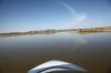
Normally glassy water would be a cautionary note for seaplaners. Before heading into the high hills, however, the lack of any big wind is a benefit.
| | Attachments:
Nicely Glassy
| | |
| | | | | | | | | | | | | | | | | | | | |