|
|
 |
|
|
|
|
|
|
|
|
|
|
|
|
|

Click on photo to view the original size. |
| Viewers
|
|
|
|
|
|
|
|
|
|
|
Read what others had to say:
|
|
|
|
|
|
|
 |
Dan Nickens - May 13,2012
Viewers
| Reply
|
| |
Cruising through Indian country in style: the Chinle Valley lies within the Navajo Nation.
| | Attachments:
Mesa Cruising
| | |
|
Dan Nickens - May 13,2012
Viewers
| Reply
|
| |
The Red Valley lies between the Carrizo and Chuska Mountains. The two SeaReys slid past the mountains and stuck to the sometimes mostly flat valley and its mesas.
| | Attachments:
Following Flat
| | |
|
Dan Nickens - May 13,2012
Viewers
| Reply
|
| |
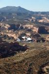
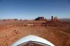
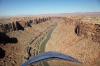
You just know it’s going to be a great flight when you’re heading into a Monument Valley that looks like this. (Crossing Comb Ridge on the way to the Valley.)
| | Attachments:
Approaching Monumental
| | |
|
Don Maxwell - May 13,2012
Viewers
| Reply
|
| |
Nice reflection on the windscreen, too.
| | |
|
Dan Nickens - May 13,2012
Viewers
| Reply
|
| |
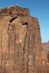
Flying into rocks isn’t always a bad thing….as long as you fly back out again.
| | Attachments:
Flying into the Rocks
| | |
|
Dan Nickens - May 13,2012
Viewers
| Reply
|
| |
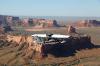
It’s not just a small plane, it’s big rock.
| | Attachments:
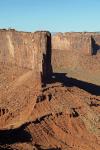
Scale Matters
| | |
|
Don Maxwell - May 13,2012
Viewers
| Reply
|
| |
Monumental!
| | |
|
Dan Nickens - May 13,2012
Viewers
| Reply
|
| |
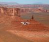
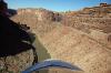
On a good day getting close to the big rocks can induce a larger perspective.
| | Attachments:
Close Pass
| | |
|
John Robert Dunlop - Jun 01,2012
Viewers
| Reply
|
| |
Yikes, that big rock!
| | |
|
Dan Nickens - May 13,2012
Viewers
| Reply
|
| |
Who knew the old game of following the leader was still fun to play!
| | Attachments:
Follow the Leader
| | |
|
Dan Nickens - May 13,2012
Viewers
| Reply
|
| |
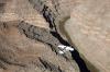
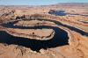
The Goosenecks canyon is a short crossing. The meanderings of the San Juan River were deeply etched in rock when the surrounding land was lifted during the Monument Upwarp. The river is now 1000’ below its former bed.
| | Attachments:

Canyon Crossing
| | |
|
Dan Nickens - May 13,2012
Viewers
| Reply
|
| |
Turning into the canyon is a temptation….except for those tight turns with rocks at the end.
| | Attachments:
Turning In
| | |
|
Dan Nickens - May 13,2012
Viewers
| Reply
|
| |
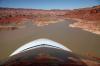
After the narrow and deep Goosenecks, the river canyon opens up nicely.
| | Attachments:
An Opening
| | |
|
Dan Nickens - May 13,2012
Viewers
| Reply
|
| |
When the river opens up, it’s an invitation to drop in.
| | Attachments:
Canyon Running
| | |
|
Don Maxwell - May 13,2012
Viewers
| Reply
|
| |
Dan, you know you were giving Richard the willies, down there. He said as much (and more!)in his blog: <a href="http://richardbach.com/practical-precognition/?utm_source=feedburner&utm_medium=email&utm_campaign=Feed%3A+RichardBach+%28Richard+Bach%29">http://richardbach.com/practical-precognition/?utm_source=fe<br>edburner&utm_medium=email&utm_campaign=Feed%3A+RichardBach+%<br>28Richard+Bach%29</a>
| | |
|
Dan Nickens - May 13,2012
Viewers
| Reply
|
| |
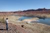
There was a sand beach just ahead of the curve. There are more, you just have to look for them (could be hard to spot higher up). Perfect for emergency maintenance!
| | |
|
Dan Nickens - May 13,2012
Viewers
| Reply
|
| |
It’s red right return for navigation, right? Well what if it’s red on all sides?
| | Attachments:
Red Ahead
| | |
|
Dan Nickens - May 13,2012
Viewers
| Reply
|
| |
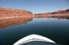
After all the hard rocks, it’s nice to find some soft water.
| | Attachments:

Smooth to Taxi
| | |
|
Dan Nickens - May 13,2012
Viewers
| Reply
|
| |
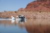
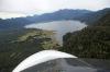
A nice quiet cove is a perfect place for a fly in lunch.
| | Attachments:
Backwater Parking
| | |
|
Dan Nickens - May 13,2012
Viewers
| Reply
|
| |
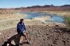
It takes a few minutes to take it all in. “This is nice.”
| | Attachments:
Richard s View
| | |
|
Don Maxwell - May 13,2012
Viewers
| Reply
|
| |
'This is nice'? Understatement of the year!
| | |
|
Dan Nickens - May 13,2012
Viewers
| Reply
|
| |
Sometimes you just have to stop and sit on the rocks to remember how hard they are.
| | Attachments:
Taking it Hard
| | |
|
Dan Nickens - May 13,2012
Viewers
| Reply
|
| |
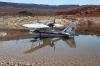
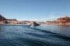
Getting off the smooth water can be disconcerting when you realize the water is at an elevation of 4000’ and its hot outside. Richard made it look easy.
| | Attachments:
Up on Plane
| | |
|
Dan Nickens - May 13,2012
Viewers
| Reply
|
| |
Richard’s ripples were still off in the distance when Whiskey Tango lifted off from the silky smoothness.
| | Attachments:
Smooth View
| | |
|
Dan Nickens - May 13,2012
Viewers
| Reply
|
| |
These are tight turns even for a SeaRey.
| | Attachments:
Tight Turns
| | |
|
Dan Nickens - May 13,2012
Viewers
| Reply
|
| |
At some time sooner rather than later it’s good to get fuel. It’s a climb up to pattern altitude.<br /><br />The Carl Black Memorial airport (U96) is a great and friendly place to get fuel. They are fighting for their lives. The Sierra Club has sued the airport because airplane noise disturbs their sense of entitlement. We signed a petition to outlaw unnaturally exclusive people who cry loudly about their nature.<br />
| | Attachments:
Going Inland
| | |
|
Dan Nickens - May 13,2012
Viewers
| Reply
|
Dan Nickens - May 13,2012
Viewers
| Reply
|
| |
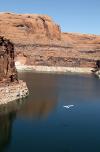
The flooded canyon is plenty big enough for SeaRey exploitation.
| | Attachments:
Down River Run
| | |
|
Dan Nickens - May 13,2012
Viewers
| Reply
|
Dan Nickens - May 13,2012
Viewers
| Reply
|
| |
Sadly, the Page airport was nearby ending a spectacular day after one last splash.
| | Attachments:
Last of the Day
| | |
|
Frank A. Carr - Jun 06,2012
Viewers
| Reply
|
| |
Truly awesome photos again, Dan. Thanks as always. Can we assume that the Corpse is not in charge out there rendering the waters usable?<!-- >'"><br><font color=red size=6>' or > missing in user HTML. Please fix the HTML.</font> -->
| | |
|
Dan Nickens - Jun 06,2012
Viewers
| Reply
|
| |
Lakes Powell and Mead are courtesy of the U. S. Bureau of Reclamation (formerly part of the U.S. Geologic Survey), Frank. There is no causal association with the Corpse of Engineers other than being part of the federal government.
| | |
|
Frank A. Carr - Jun 07,2012
Viewers
| Reply
|
| |
It's good to know Dan that some of America's Beauty is still open to Americans to see, enjoy--and photograph and share. Years ago we had the opportunity to overfly the Grand Canyon before the first No-Fly-Zones were established by one of the Park Services (not the FAA); consequently the VFR overflight corridors were drawn on a chart with a crayon and offered NO VFR landmarks or other navigational aides--and this was pre-GPS.<!-- >'"><br><font color=red size=6>' or > missing in user HTML. Please fix the HTML.</font> -->
| | |
|
Wayne Nagy - May 13,2012
Viewers
| Reply
|
| |
Thanks for bringing back memories of a 'beautiful'... in a rugged way...area of the country, Dan. I was in the top 5 for a superintendent's position for the Central Area School District and Shiprock was part of the area...A high percentage of Navajo Indians made up the student body...many teachers lived in housing on the school sites...although I was not selected, it was a wonderful educational experience in many ways!
| | |
|
|
|
|
|
|
|
|
|
|
|
| |
- About Searey.us -
- Contact Searey.us -
|
- Privacy Statement -
- Terms of service -
|
Copyright © 2024 Searey.us & Brevard Web Pro, Inc. -
Copyrights may also be reserved
by posters and used by license on this site. See Terms of Service for more information.
|
| |
- Please visit our NEW
Chapter Place Website at: chapterplace.com or
Free Chapter Management Website at: ourchapter.org. Good for all chapters, groups or families. |
| | | | | | | | | | | | | | | | | | | | | | | | | | | | | |