|
|
 |
|
|
|
|
|
|
|
|
|
|
|
|
|

Click on photo to view the original size. |
| Viewers
|
|
|
|
|
|
|
|
|
|
|
Read what others had to say:
|
|
|
|
|
|
|
 |
Dan Nickens - Apr 22,2013
Viewers
| Reply
|
| |
The fishing crew didn’t care. The helicopter took them off on a fishing trip into the cloud-shrouded mainland valleys.
| | Attachments:
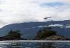
Gone Fishing
| | |
|
Dan Nickens - Apr 22,2013
Viewers
| Reply
|
| |
Freed from SuRi!<br /><br />The SeaRey was set free to relocate as it pleased. “Meet us in four hours at Islas Talcan,” was my order. That was a thirty minute flight. The rest of the time was mine.<br /><br />No sooner than I launched, passing a green point just off SuRi’s stern, the radio crackled: “SeaRey SeaRey SeaRey. SuRi calling SeaRey.”<br /><br />Now, I had a good idea of what was going on. I had seen one of my frequent flyer guests racing down from the upper deck just as I had launched. I just knew he wanted in on my free flight time. I didn’t answer the radio.<br /><br />I flew on towards the river valley. The calls continued.<br /><br />In frustration, the Captain finally called the helicopter. “We can’t raise the SeaRey. We can still see it flying north. A guest wants to fly. Can you contact him?”<br /><br />Well, there it is then. The helicopter pilot called me on the local Unicom frequency. “SuRi has a flight for you,” he advised. “If you’re not on the frequency, don’t worry about it.”<br /><br />With great regret I answered: “Roger. It’s not nice not to share. SeaRey returning to SuRi.”<br /><br />I put on a fake face and greeted the passenger warmly. The guest was not fooled. “I know you want to fly off by yourself. Let’s just do a couple of local splashes then you can be on your way.”<br /><br />YES! <br />
| | Attachments:
Green Point
| | |
|
Dan Nickens - Apr 22,2013
Viewers
| Reply
|
| |
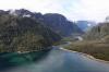
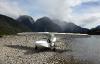
Free at last, free at last. Thank goodness I’m free to fly….by myself…up the estuary at the mouth of Rio Yelcho
| | Attachments:
Yelcho Estuary
| | |
|
Dan Nickens - Apr 22,2013
Viewers
| Reply
|
| |
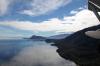
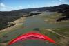
Where to go? Anywhere I want within four hour range (except where the clouds cover the big rocks).
| | Attachments:
Cloudy on Top
| | |
|
Dan Nickens - Apr 22,2013
Viewers
| Reply
|
| |
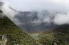
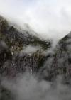
The clouds cover the tops, but the valleys were clear. Maybe it would be like yesterday. Clear inland. I decided to go look. If I could get through the pass to blue skies I could climb to the ice fields on top.
| | Attachments:
UpStream
| | |
|
Dan Nickens - Apr 22,2013
Viewers
| Reply
|
| |
It was my first time trying out this river valley. Fernando told me I could follow it up to the lakes around el Volcan Corcovado. He didn’t describe how it quickly narrowed.
| | Attachments:
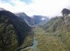
Getting Tight
| | |
|
Dan Nickens - Apr 22,2013
Viewers
| Reply
|
| |
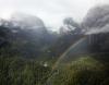
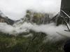
Off to the side of the main valley there were plenty of clouds and some rain. A rainbow, however, appeared to spur on hope of blue skies and sunshine.
| | Attachments:
Rainbow Valley
| | |
|
Dan Nickens - Apr 22,2013
Viewers
| Reply
|
| |
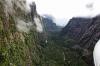
Even with a rainbow on the SeaRey’s bow, the signs ahead were not looking all that blue.
| | Attachments:

Rainbow on the bow
| | |
|
Dan Nickens - Apr 22,2013
Viewers
| Reply
|
| |
The valley ahead looked too small to turn around in comfortably. Even with a rainbow I decided to turn sooner rather than later.
| | Attachments:
Rainbow End
| | |
|
Dan Nickens - Apr 22,2013
Viewers
| Reply
|
| |
Falls shrouded in clouds told me I was ever so close to the glaciers. Close, but no ice.
| | Attachments:
Cloud Falls
| | |
|
Dan Nickens - Apr 22,2013
Viewers
| Reply
|
| |
It wasn’t getting better going out. I was wings level with the clouds.
| | Attachments:
Cloud Level
| | |
|
Dan Nickens - Apr 22,2013
Viewers
| Reply
|
| |
Hmmm…there wasn’t rain there when I flew into the valley.
| | Attachments:
Close Walls
| | |
|
Dan Nickens - Apr 22,2013
Viewers
| Reply
|
Dan Nickens - Apr 22,2013
Viewers
| Reply
|
Dan Nickens - Apr 22,2013
Viewers
| Reply
|
| |
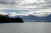
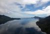
Out of the narrow clutches of the Andes and back to the big blue bay.
| | Attachments:
Blue Bay
| | |
|
Dan Nickens - Apr 22,2013
Viewers
| Reply
|
| |
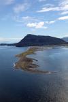
A point of land without glaciers on top might have been a little less spectacular, but it was accessible by SeaRey.
| | Attachments:
Point in Blue
| | |
|
Dan Nickens - Apr 22,2013
Viewers
| Reply
|
| |
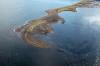
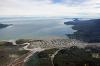
A barrier beach connected to Punta García beckoned exploration by SeaRey.
| | Attachments:
Shallow Point
| | |
|
Dan Nickens - Apr 22,2013
Viewers
| Reply
|
| |
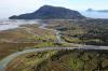
Suitable for a wheeled landing? Maybe. But there were distractions.
| | Attachments:
Barrier Beach
| | |
|
Dan Nickens - Apr 22,2013
Viewers
| Reply
|
| |
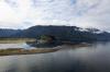
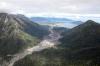
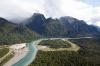
The mouth of Rio Yelcho lay just behind the barrier beach. Just beyond that was a distraction of volcanic proportion.
| | Attachments:
River Estuary
| | |
|
Dan Nickens - Apr 22,2013
Viewers
| Reply
|
| |
The eruption of Volcan ChaitUn in May 2008 covered the surrounding countryside with translucent gray obsidian ash two to four inches thick. It wasn’t done with one eruption, though.
| | Attachments:
Scorched Earth
| | |
|
Dan Nickens - Apr 22,2013
Viewers
| Reply
|
| |
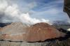
The volcano was still smoking four years later.
| | Attachments:
Hot Top
| | |
|
Dan Nickens - Apr 22,2013
Viewers
| Reply
|
| |
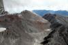
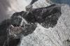
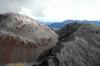
Dante’s inferno brought to life. And it’s a rare species. Volcan ChaitUn represents the first major eruption of rhyolite magma since a 1912 eruption in Alaska.
| | Attachments:
No Man s Land
| | |
|
Dan Nickens - Apr 22,2013
Viewers
| Reply
|
| |
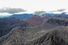
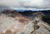
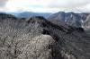
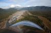
A new mountain top grows inside the blown out remains of the old top (until/unless it blows out again). The first eruption in May 2008 followed 9000 years of quiet. That eruption flooded the town when the Blanco River’s course was forcefully altered.
| | Attachments:
Buldging Rocks
| | |
|
Dan Nickens - Apr 22,2013
Viewers
| Reply
|
| |
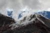
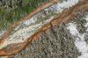
The rim of the old crater had its fair share of hot stuff, but some tree trunks are still standing.
| | Attachments:
Blasted Edge
| | |
|
Dan Nickens - Apr 22,2013
Viewers
| Reply
|
| |
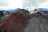
The new mountain top has some growing to do before it fills the void left by the old one. After forming a new lava dome in 2008, it collapsed in February 2009, sending pyroclastic flows into the valley.
| | Attachments:
Emerging Rock
| | |
|
Dan Nickens - Apr 22,2013
Viewers
| Reply
|
| |
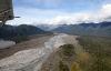
Four years earlier (February 2009) a volcano unleashed a vicious lahar (a toxic mixture of mud, ash, debris and water), enveloping the town of ChaitUn in three feet of the nasty gray stuff with the viscosity of wet concrete. The residents were successfully evacuated and the town ordered abandoned.
| | Attachments:
Path of Destruction
| | |
|
Dan Nickens - Apr 22,2013
Viewers
| Reply
|
| |
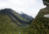
Leaving the volcano behind, up a river valley there was another rainbow waiting. It was a nice change from the dead gray of volcano blasted mountains.
| | Attachments:
Rainbow Crossing
| | |
|
Dan Nickens - Apr 22,2013
Viewers
| Reply
|
| |
It was lunchtime. No fancy lobster bisque from SuRi’s galley. Just some granola bars and a bottle of lemonade. Perfect.
| | Attachments:
Beautifully Beached
| | |
|
Dan Nickens - Apr 22,2013
Viewers
| Reply
|
| |
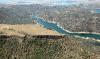
Following the river inland to a huge interior lake.
| | Attachments:
Lake Approach
| | |
|
Dan Nickens - Apr 22,2013
Viewers
| Reply
|
| |
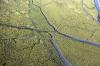
An ox bow in the river valley shows the fickle path of water…or a blocking rain of ash.
| | Attachments:
Old River Bend
| | |
|
Dan Nickens - Apr 22,2013
Viewers
| Reply
|
Dan Nickens - Apr 22,2013
Viewers
| Reply
|
| |
Remnants of the small village of ChaitUn lie in the gray mass of mud and rock that rolled down from the volcano. The government was successful in evacuating the town and no one died in the mud flow. Well, one guy died of a heart attack during the evacuation. He might argue that he was a victim (if he cares).<br /><br />The government worked out a plan to move the town to a safer location. Not everyone wanted to leave. Some have returned. The Occupy ChaitUn movement is apparently gaining strength. After all, the volcano has been quietly smoking for four years. What’s the worst that could happen? And how soon could it happen? Maybe another 9000 years to the next eruption in a good case scenario?<br />
| | Attachments:
Ghost Town
| | |
|
Dan Nickens - Apr 22,2013
Viewers
| Reply
|
Dan Nickens - Apr 22,2013
Viewers
| Reply
|
| |
I decided to return for another look. The volcano has been quietly smoking for four years. What’s the worst that could happen?
| | Attachments:
Molten Mass
| | |
|
Dan Nickens - Apr 22,2013
Viewers
| Reply
|
| |
The terrain around the volcano was magma blasted and then coated in ash.
| | Attachments:

Blasted Ground
| | |
|
Dan Nickens - Apr 22,2013
Viewers
| Reply
|
| |
The ground and trees are covered in ash near the volcano. National Geographic says it’s an environmental disaster for the frogs. Darwin’s frogs have a very specific strategy: they look like a brown leaf. That’s a good way to avoid predators, unless the leaves are gone and the ground is gray. Their other strategy is suspect too: the male frog guards the eggs until they hatch then takes the survivors into its vocal pouch, keeping them there until they are big enough to hop away.
| | Attachments:
Coat of Ash
| | |
|
Dan Nickens - Apr 22,2013
Viewers
| Reply
|
| |
Ground zero looked like something from an apocalypse movie.
| | Attachments:

Ground Zero
| | |
|
Dan Nickens - Apr 22,2013
Viewers
| Reply
|
| |
Lots of nasty chemicals in volcanoes and greenhouse gases spewed out by volcanoes, including CO2, methane and SO2. Fortunately the ash they pump out offsets the greenhouse properties by promoting worldwide climate cooling.
| | Attachments:
Toxic Runoff
| | |
|
Dan Nickens - Apr 22,2013
Viewers
| Reply
|
| |
Ash laden outflow from the volcano.
| | Attachments:
Gray Flow
| | |
|
Tom Binsfeld - Apr 22,2013
Viewers
| Reply
|
| |
Wow!!!!!!!!
| | |
|
Dan Nickens - Apr 22,2013
Viewers
| Reply
|
| |
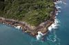
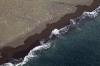
Volcanic Beach at Punta Navarro, Isla Puduguapi
| | Attachments:
Black Beach
| | |
|
Dan Nickens - Apr 22,2013
Viewers
| Reply
|
| |
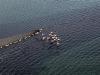
Great Grebes! That’s what Fernando thought. I was not so sure. <br />Maybe a Grebe family has met the flamingo family? It turns out the <br />there is a Chilean Flamingo (Phoenicopterus chilensis) that has no <br />relation to the Great Grebe.
| | Attachments:
Flight of Birds
| | |
|
Dan Nickens - Apr 22,2013
Viewers
| Reply
|
| |
An island imitating a platform? It would have been fun to land on top, but the breeze wasn’t that brisk!
| | Attachments:
Flat top
| | |
|
Don Maxwell - Apr 22,2013
Viewers
| Reply
|
| |
That's bizarre! What's the size of that thing?
| | |
|
Dan Nickens - Apr 22,2013
Viewers
| Reply
|
| |
It's a good size rock, Don. I'm guessing 100 meters across on top.
| | |
|
Dan Nickens - Apr 23,2013
Viewers
| Reply
|
| |
Google Earth has a picture of it labeled Silla del Diablo (my chart calls it Islote Nihuel.....maybe the photographer didn't like Niheul?). Measuring on the Google yields 125 meters west to east, and 135 meters north to south.
| | |
|
Dan Nickens - Apr 22,2013
Viewers
| Reply
|
| |
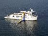
It was supposed to be warmer in the gulf. And the water was a little warmer, but not warm enough to go for a slide-n-swim. At least there wasn’t any fog.
| | Attachments:
SuRi Slides
| | |
|
Dan Nickens - Apr 22,2013
Viewers
| Reply
|
| |
After enthusiastically describing the volcano, one of the guests wanted to go back to see it. Only one. We took the SeaRey.
| | Attachments:
Back to Volcan
| | |
|
Dan Nickens - Apr 22,2013
Viewers
| Reply
|
| |
Maybe volcanoes get hotter in the afternoon. It did seem steamier. That’s when I started thinking about “exposure.” Three times in one day? I recall a story of the pilot that was over Mount St. Helens in a C182 when it blew. Years later he flew back by with the chief of a native American tribe. The volcano burped some smoke. The Chief told the pilot that the gods were trying to tell him that he should avoid this place. He is reported to have never been back.
| | Attachments:
Blowing Smoke
| | |
|
Dan Nickens - Apr 22,2013
Viewers
| Reply
|
| |
Getting around the volcano was almost getting routine. (Not. I kept thinking I could be peeving off the Pillán.)
| | Attachments:

Fly By
| | |
|
Dan Nickens - Apr 22,2013
Viewers
| Reply
|
| |
Out on the coast we went in search of more pink Great Grebes or Chilean Flamingos. We didn’t find any.
| | Attachments:
Coastal Marsh
| | |
|
Dan Nickens - Apr 22,2013
Viewers
| Reply
|
| |
As usual it was a late return to Suri. On the way back I spotted smoke on the water. Great geysers of gray smoke! Two. Three and more. Baby volcanoes?<br /><br />Flying to investigate it was soon apparent that each geyser was associated with a massive submerged object. Chilean submarines? No! Whales! When we arrived over the scene they vanished.<br /><br />My guest wasn’t interested in waiting until they came back up for air. Something about half past happy hour.<br />
| | Attachments:
Late Return
| | |
|
Dan Nickens - Apr 22,2013
Viewers
| Reply
|
| |
I don’t know what the guest was talking about. It was already happy hour for me (well, happy day, er, week, actually).<br /><br />And if the guests don’t like these clouds, well, they’re pretty hard to please! Good parking, Captain.
| | Attachments:

Channel Skies
| | |
|
|
|
|
|
|
|
|
|
|
| |
- About Searey.us -
- Contact Searey.us -
|
- Privacy Statement -
- Terms of service -
|
Copyright © 2024 Searey.us & Brevard Web Pro, Inc. -
Copyrights may also be reserved
by posters and used by license on this site. See Terms of Service for more information.
|
| |
- Please visit our NEW
Chapter Place Website at: chapterplace.com or
Free Chapter Management Website at: ourchapter.org. Good for all chapters, groups or families. |
| | | | | | | | | | | | | | | | | | | | | | | | | | | | | | | | | | | | | | | | | | | | | | | | | |