|
|
 |
|
|
|
|
|
|
|
|
|
|
|
|
|

Click on photo to view the original size. |
| Viewers
|
|
|
|
|
|
|
|
|
|
|
Read what others had to say:
|
|
|
|
|
|
|
 |
Dan Nickens - May 02,2014
Viewers
| Reply
|
| |
Spurred on by the sight of surrounding hills and smooth, crystalline water, releasing the SeaRey couldn’t happen soon enough.
| | Attachments:
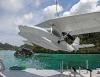
Let It Loose
| | |
|
Dan Nickens - May 02,2014
Viewers
| Reply
|
| |
Prospects for an amazing aerial survey were looking good from water level. The towering limestone hills had dramatic slopes. Checking their bases at the tide line, you could see evidence of solution undercutting the rock.<br /><br />
| | Attachments:
Two to Start
| | |
|
Dan Nickens - May 02,2014
Viewers
| Reply
|
| |
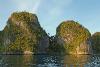
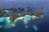
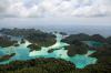
Conical shaped hills covered in dark green rainforest, surrounded by blue and sapphire water made for stunning visuals. The Raja Ampat islands are karst topography in its most dramatic form, pushed up on the edge of multiple tectonic plates (Eurasian, Filipino, Australian, and Pacific).
| | Attachments:
Strange Terrain
| | |
|
Dan Nickens - May 02,2014
Viewers
| Reply
|
| |
No worries about overcrowding. The only other people near the island were the park ranger and a sailboat in another cove.
| | Attachments:
Private Parking
| | |
|
Buck Bray - May 02,2014
Viewers
| Reply
|
| |
Paradise, Dan. Do you think the ranger would welcome an assistant flying a Searey?
| | |
|
Dan Nickens - May 02,2014
Viewers
| Reply
|
| |
Perhaps, Buck, but have you ever seen an Indonesian toilet? Now, if you could get the ranger to install plumbing and air conditioning, that would be paradise! (He does have a great beach.)<br /><br />You might want to start typing up your resume, though, because Matt (our local guide from Bali) is working on a plan to bring in a SeaRey for tourism and humanitarian work in Raja Ampat.
| | |
|
Buck Bray - May 02,2014
Viewers
| Reply
|
| |
Generally a good idea to move your feet while flushing/splashing. You are a true Searey <br />ambassador. Thanks for sharing your adventures.
| | |
|
Dan Nickens - May 02,2014
Viewers
| Reply
|
| |
Ah, so that's the trick!
| | |
|
Dan Nickens - May 02,2014
Viewers
| Reply
|
| |
The SeaRey wasn’t the only aerial photo platform. The SuRi’s drone was hard at work too. Fortunately, the operator kept a close eye on both the SeaRey and the drone. I was too distracted by the scenery to watch for a drone.
| | Attachments:
Drone View
| | |
|
Don Maxwell - May 02,2014
Viewers
| Reply
|
| |
What a shot! Dan, that hardly looks of this planet.
| | |
|
Dan Nickens - May 02,2014
Viewers
| Reply
|
| |
True, Don. It's a strange new world of aerial mayhem.
| | |
|
Frank A. Carr - May 03,2014
Viewers
| Reply
|
| |
But the view does look like a GoPro view which raises the Question Dan, why does SuRi's SeaRey not have a full compliment of GoPros? Along with a full video production lab of techs?<!-- >'"><br><font color=red size=6>' or > missing in user HTML. Please fix the HTML.</font> -->
| | |
|
Dan Nickens - May 03,2014
Viewers
| Reply
|
| |
Oh, it does, Frank. It's just that its SeaRey pilot is stuck in the last century and still life photos.
| | |
|
Frank A. Carr - May 04,2014
Viewers
| Reply
|
| |
Dan, Just get the boss to buy the GoPros and hire Lima and Russ to work the 21st Century editing. Done.<!-- >'"><br><font color=red size=6>' or > missing in user HTML. Please fix the HTML.</font> -->
| | |
|
Dan Nickens - May 04,2014
Viewers
| Reply
|
| |
There is one flaw in your proposal, Frank. I'd have to find lots of pretty girls to get Dave interested in the project.
| | |
|
Dan Nickens - May 02,2014
Viewers
| Reply
|
| |
Palau Wayag isn’t close to any tourist accommodations. There are a few resorts that are many hours away by boat (it’s 200 miles roundtrip by boat from Waisai).
| | Attachments:
Secluded Shores
| | |
|
Dan Nickens - May 02,2014
Viewers
| Reply
|
| |
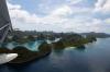
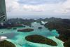
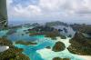
A view from above shows how difficult it would be to survey the whole island by boat. The maze of waterways is difficult enough to navigate, but throw in shallow reefs and the level of difficulty escalates considerably. To get a high view, climbing vertiginous cliffs with sharp rock edges is a formidable obstacle to overcome. Some care has to be exercised for poisonous snakes, spiders and plants. Repellent for malaria bearing mosquitoes would be prudent too.<br /><br />And, it’s 20 km north of the equator. It is hot and humid. The canopies on the SeaRey were open all day long.<br />
| | Attachments:
Liquid Maze
| | |
|
Dan Nickens - May 02,2014
Viewers
| Reply
|
| |
Mogotes, the isolated karst hills with steep sides, are a beautiful example of terraqueous artistry.
| | Attachments:
Green Globs
| | |
|
Dan Nickens - May 02,2014
Viewers
| Reply
|
| |
Dreamy white sand beaches with coconut palms surrounded by crystalline waters? Reality? Check.
| | Attachments:

Beach Dream
| | |
|
Dan Nickens - May 02,2014
Viewers
| Reply
|
| |
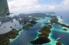
Last year the island was closed to visitors. In fact, until just very recently (February), the island was off limits because the tribe of original owners on Palua Kawe decided it wasn’t getting sufficient revenue from tourism, and it restricted access. Now each international visitor pays a marine park access fee of 500,000 Indonesian Rupiah (about US$50). A bargain.<br /><br />
| | Attachments:
Restricted Access
| | |
|
Dan Nickens - May 02,2014
Viewers
| Reply
|
| |
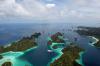
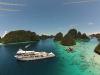
Scattered to broken karst islands with towering peaks made for a great hydroaviation forecast.
| | Attachments:
Islets Galore
| | |
|
Dan Nickens - May 02,2014
Viewers
| Reply
|
| |
What is a karst island without a good sea cave!
| | Attachments:
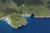
Secret Cave
| | |
|
Dan Nickens - May 02,2014
Viewers
| Reply
|
| |
After earlier outings with the SuRi, I think I’ve finally gotten the Captain trained. He couldn’t have picked a nicer SeaRey spot. There was no monstrous ocean swell or hull-splitting gale blown waves. Just calmly rippled water.<br /><br />Even with a late start, the SeaRey was booked all day. Five hours and 14 splash downs from start to finish. Ten happy customers (and others not so happy that had to delay their SeaRey gratifications for another day). <br /><br />
| | Attachments:

Protected Parking
| | |
|
Robert Charlwood Richardson - May 02,2014
Viewers
| Reply
|
| |
Looking at your running commentary, now ii understand why the pre-WWII cruisers & battleship carried <br />float planes. I am sure you Suri Captian appreciates your Airedale reports
| | |
|
Dan Nickens - May 02,2014
Viewers
| Reply
|
| |
It seems so, Rob. Before the end of the trip I had him convinced that the SeaRey is a better aquatic observer than the helicopter. Now if I can just shoot down that drone......<!-- >'"><br><font color=red size=6>' or > missing in user HTML. Please fix the HTML.</font> -->
| | |
|
Dennis Scearce - May 03,2014
Viewers
| Reply
|
| |
If these pictures didn't look so real, I'd swear you were making all this up.
| | |
|
Dan Nickens - May 03,2014
Viewers
| Reply
|
| |
In way of supporting documentation, Dennis, allow me to add this short video made by Matt. (I'm trying to figure out this useless-tube video thing and when (if) I do I'll delete the file from here.) .......Done, thanks to Dave.<br />
| | Attachments:

Wayag SeaRey Launch
| | |
|
Dave Lima - May 03,2014
Viewers
| Reply
|
| |
https://<a href="http://www.youtube.com/watch?v=zgPtewMhAoE&feature=youtu.be">www.youtube.com/watch?v=zgPtewMhAoE&feature=youtu.be</a><br /><br />Here you go Dan. We (myself) take for granted all the pictures you post, so in case I forget to say it...Thanks!!!<br /><br />Once you see the plane in the video it put into perspective just how large those islands are!
| | |
|
|
|
|
|
|
|
|
|
| |
- About Searey.us -
- Contact Searey.us -
|
- Privacy Statement -
- Terms of service -
|
Copyright © 2024 Searey.us & Brevard Web Pro, Inc. -
Copyrights may also be reserved
by posters and used by license on this site. See Terms of Service for more information.
|
| |
- Please visit our NEW
Chapter Place Website at: chapterplace.com or
Free Chapter Management Website at: ourchapter.org. Good for all chapters, groups or families. |
| | | | | | | | | | | | | | | | | | | | | | | | | |