|
|
 |
|
|
|
|
|
|
|
|
Posted By:
Hal Brown
Date Posted:
May 6, 2014
Description:
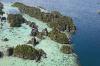
“Red skies at morning, sailors take warning.”
Or, as Shakespeare would say,
“Like a red morn that ever yet betokened,
Wreck to the seaman, tempest to the field,
Sorrow to the shepherds, woe unto the birds,
Gusts and foul flaws to herdmen and to herds.”
From Venus and Adonis
Date Taken:
May 6, 2014
Place Taken:
Eastern Misool, West Papua, Indonesia
Owner:
Dan Nickens
File Name:
Morning_Break.jpg - Photo HTML
Full size - <img src="/show.php?splash=SZDU60000h">
Medium - <img src="/show.php?splash=SZDU60000m">
Thumbnail - <img src="/show.php?splash=SZDU60000s">
Category:
549, Yacht Tending Indo
|
|
|
|
|

Click on photo to view the original size. |
| Viewers
|
|
|
|
|
|
|
|
|
|
|
Read what others had to say:
|
|
|
|
|
|
|
 |
Dan Nickens - May 06,2014
Viewers
| Reply
|
| |
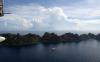
There were plenty of red flags warning. Having a disabled SeaRey was already trouble enough to start the day.<br /><br />Luckily it didn’t take long to find the source of the engine’s problem: fuel starvation. The fuel filter was coated in a gelatinous goo. The ship’s engineer just shook his head and said, “The fuel here is @#$%*!”<br /><br />“So I was told. That is why we triple filter it.”<br /><br />“This goo is likely the result of oxidation of old fuel. You can’t filter that.”<br /><br />“Why do we have old fuel? Didn’t you top off the tanks before the trip?”<br /><br />“We have 300 gallons of fuel we purchased just before the trip. It came from Sorong. Who knows where it was before then or how long it took to get here. We’ve been having trouble with all the gasoline engines.”<br /><br />“So, what can I do about the airplane?”<br /><br />“Change the engine to diesel or jet fuel. Or, don’t fly anywhere you can’t land when the engine quits.”<br /><br />That’s always good advice.<br /><br />Though the SeaRey was running again, there were other problems. Storm clouds stretched around the horizon. And, completely ignoring my pleas, the Captain had parked SuRi in big ocean swell. To depart I had to taxi into a cove and depart through a tight corridor of limestone.<br /><br />On the plus side, the local scenery was particularly spectacular.<br />
| | Attachments:
Early Scene
| | |
|
Dan Nickens - May 06,2014
Viewers
| Reply
|
| |
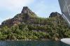
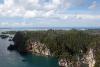
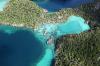
The limestone cliffs on the long narrow islands jutting out of the eastern portion of Misool were to provide some protection from the wind and swell according to the Captain’s weather forecast. For the present, that was just a distant promise.
| | Attachments:
Big Rocks
| | |
|
Dan Nickens - May 06,2014
Viewers
| Reply
|
| |
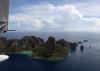
Flying east, it didn’t take long to run out of the narrow stretch of land.
| | Attachments:
End of Line
| | |
|
Dan Nickens - May 06,2014
Viewers
| Reply
|
| |
The line of land wasn’t complete. There were numerous breaks and holes.
| | Attachments:
Holes in the Line
| | |
|
Dan Nickens - May 06,2014
Viewers
| Reply
|
| |
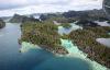
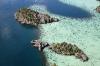
Big channels separated the narrow finger of land extending out from Misool.
| | Attachments:
Channel Break
| | |
|
Dan Nickens - May 06,2014
Viewers
| Reply
|
| |
The breaks in the land got more numerous flying west along the line.
| | Attachments:

Twisted Water
| | |
|
Dan Nickens - May 06,2014
Viewers
| Reply
|
| |
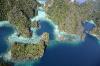
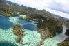
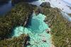
If this were Central America, the deep blue holes would be cenots, formed from the sinkhole-like collapse of limestone. Unsure of the local terminology, I just settled on pointing out the deep blue holes to my aerial guests.
| | Attachments:

Deep Blue Holes
| | |
|
Dan Nickens - May 06,2014
Viewers
| Reply
|
| |
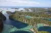
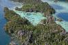
The further west I went, the more complicated the land and water got. It was fascinating to ease into.
| | Attachments:
Landform Complicated
| | |
|
Dan Nickens - May 06,2014
Viewers
| Reply
|
| |
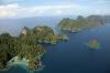
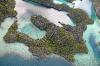
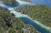
From SeaRey eye level, the patterns were apparent: an east-west ridge of land, transected by north-south faulting and punctuated by deep blue holes. Were the labyrinth of lagoons visible from boat eye level? Not so much.
| | Attachments:

More Complication
| | |
|
Dan Nickens - May 06,2014
Viewers
| Reply
|
| |
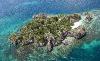
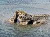
If the gross form of topography was impressive, the rock level was absolutely amazing in its complex form.
| | Attachments:

Line Break
| | |
|
Dan Nickens - May 06,2014
Viewers
| Reply
|
| |
Conical mountains and rocky spires sprinkled with green rain forest growing on stark rock, surrounded by liquid blues. It couldn’t get any more dramatic.
| | Attachments:
Sea Rockland
| | |
|
Dan Nickens - May 06,2014
Viewers
| Reply
|
| |
Only it did get more dramatic. Close inspection of the rocky spires showed their sharpness, their intricate structures.
| | Attachments:

Ragged Edges
| | |
|
Dan Nickens - May 06,2014
Viewers
| Reply
|
| |
The aerial view was stunning. I decided to see what was going on down at boat level.
| | Attachments:

Sharp Rocks
| | |
|
Dan Nickens - May 06,2014
Viewers
| Reply
|
| |
The view from boat level was pretty cool too. You could see all the details that just flash by at SeaRey speeds.
| | Attachments:

Razor Rocks
| | |
|
Dan Nickens - May 06,2014
Viewers
| Reply
|
| |
Our guide Matt told me this area is known as “The Bay of 1000 Temples”. I can’t confirm that, but I do know there were more stone temples than I could count.
| | Attachments:

3 Temples
| | |
|
Dan Nickens - May 06,2014
Viewers
| Reply
|
| |
My tour of 1000 Temples was aided by a spotter. One of the guests with extremely sharp eyes came along to spot exotic fish. She was completely distracted by the out-of-world scenery.<br /><br />She shook her head and solemnly said, “These have been the best two days of my life.”<br /><br />I didn’t respond, just staring at her to see if it were true.<br /><br />“Well, except for my wedding day,” she added hastily.<br /><br />Right.<br />
| | Attachments:

The Spotter
| | |
|
Dan Nickens - May 06,2014
Viewers
| Reply
|
| |
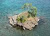
The wild topography did not leave out the special touch of hidden beaches.
| | Attachments:
Touch of Beach
| | |
|
Dan Nickens - May 06,2014
Viewers
| Reply
|
| |
Serrated knife edge rocks balanced on narrow table tops. You just can’t make this stuff up. Whatever you can imagine, nature has it covered and then some.
| | Attachments:

Stone Blades
| | |
|
Dan Nickens - May 06,2014
Viewers
| Reply
|
| |
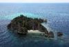
Away from the densely packed stone temples, there were some outlying islets. Complete with beautiful little personal beaches.
| | Attachments:

Outliers
| | |
|
Dan Nickens - May 06,2014
Viewers
| Reply
|
| |
The weather forecast of a red morning was not to be voided by spectacular stone temples. Scattered storms were popping up, easily circumnavigated by SeaRey. When I got too close, it was a simple matter of sliding the canopy closed for a few minutes. Having a sliding canopy is a great plus for keeping dry. Passing the rain squalls the canopies opened right up for unobstructed viewing. I pity the planes that only have closed or even “removable” canopies on days like this!
| | Attachments:

Partly Stormy
| | |
|
Dan Nickens - May 06,2014
Viewers
| Reply
|
| |
The masses of rock dissipated around the edges, leaving isolated remnants. Matt said some of these have ancient petroglyphs of hands and fish.
| | Attachments:

Last Remnants
| | |
|
Dan Nickens - May 06,2014
Viewers
| Reply
|
| |
Evidence of the tide lines were everywhere the limestone cliffs stood. Solution is more rapid at water level.
| | Attachments:

Undercuts
| | |
|
Dan Nickens - May 06,2014
Viewers
| Reply
|
| |
Particularly intriguing for SeaRey explorers are beaching options. This one looked pretty good, except for those dangerous coconut trees!
| | Attachments:
Sandy Spot
| | |
|
Dan Nickens - May 06,2014
Viewers
| Reply
|
| |
Things were getting dicey with storm cells popping up around the islands. Fortunately SuRi was not far away. Unfortunately I was growing increasingly concerned that not everyone would see the splendid temples. I was shuttling passengers as fast as I could.<br /><br />One trip back I suggested that the helicopter be deployed to make sure everyone got to see the unique sights. The Captain agreed. The owner insisted that the doors be removed from the helicopter so its passengers could have a semblance of the SeaRey experience. Grudgingly, the contract helicopter pilot complied. He could see the building storm clouds.<br /><br />Not that it mattered. He took off without consulting with the guides or me. He promptly took a wrong turn and headed east. Not that the scenery wasn’t great that way, it just wasn’t the labyrinth of stone temples to the left.<br /><br />He didn’t answer my radio calls. I hadn’t briefed him on SuRi radio protocols. His passengers got a fine flight, just not the once-in-a-lifetime flight.<br />
| | Attachments:

Exploding Rain
| | |
|
Dan Nickens - May 06,2014
Viewers
| Reply
|
| |
Meanwhile I was “tolling” away showing off the priceless pearls of temples and beaches one person per trip.
| | Attachments:
Beach Haven
| | |
|
Dan Nickens - May 06,2014
Viewers
| Reply
|
| |
One of the minor faults in the limestone ridge lay perpendicular to the spiny ridges. Sometimes these opened into passages.
| | Attachments:

A Way Through
| | |
|
Dan Nickens - May 06,2014
Viewers
| Reply
|
| |
The chief stewardess had time for a flight during the guests’ extended dive trips. I was determined to find a beach to show her. There were many options, but I was holding out for a perfect one.
| | Attachments:

Island Options
| | |
|
Dan Nickens - May 06,2014
Viewers
| Reply
|
| |
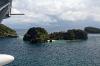
What could be more perfect than an island with three beaches? Hard to imagine, but I wasn’t ready to choose just one so early in the flight. Let the exploration continue!
| | Attachments:

3 Beaches
| | |
|
Dan Nickens - May 06,2014
Viewers
| Reply
|
| |
Looking at the rock lines you can see how the formations are tilted up towards the center of the ridge line. Folded and faulted. All good for fantastic landscapes!
| | Attachments:

Rock Lines
| | |
|
Dan Nickens - May 06,2014
Viewers
| Reply
|
| |
Wild structures were everywhere in this rock fantasyland.
| | Attachments:

Ruffled Rock
| | |
|
Dan Nickens - May 06,2014
Viewers
| Reply
|
| |
Not so far away there were rocks with lots of stripes on a parallel line.
| | Attachments:

Rock Stripes
| | |
|
Dan Nickens - May 06,2014
Viewers
| Reply
|
| |
A beautiful little plot of green grew atop the rocks. It was amazing to see the roots reaching down into limestone crevices with no need for thick soil.
| | Attachments:
Rock Garden
| | |
|
Dan Nickens - May 06,2014
Viewers
| Reply
|
| |
Not all the rock was limestone. There was also mudstone and sandstone. The mudstone looked like it was piled on in classic wedding cake style.
| | Attachments:

Layered Land
| | |
|
Dan Nickens - May 06,2014
Viewers
| Reply
|
| |
Cutting through the rocks like saw slices were parallel fractures.
| | Attachments:

Fault Lines
| | |
|
Dan Nickens - May 06,2014
Viewers
| Reply
|
| |
It is the cracking and stresses in the bent, folded and mutilated rocks that lead to the resulting labyrinths.
| | Attachments:
Cracking Up
| | |
|
Dan Nickens - May 06,2014
Viewers
| Reply
|
| |
Growing in the heat, humidity and rain gives the green stuff a chance to grow luxuriantly almost anywhere.
| | Attachments:

Green Cap
| | |
|
Dan Nickens - May 06,2014
Viewers
| Reply
|
| |
And, in shallower places, a beach can grow. The beaches were not your typical quartz sand, though. There was plenty of ground up reef and shell fragments mixed with sand.
| | Attachments:

Quiet Corner
| | |
|
Dan Nickens - May 06,2014
Viewers
| Reply
|
| |
There were plenty of miniature sea caves. Some big ones too.
| | Attachments:
Holed Rock
| | |
|
Dan Nickens - May 06,2014
Viewers
| Reply
|
| |
With more time I would have taxied right up on this nice rock ledge. There were, however, guests and crew lined up for the SeaRey tours. I couldn’t stand the thought that anyone would have to miss this stuff.
| | Attachments:

Fractured Islet
| | |
|
Dan Nickens - May 06,2014
Viewers
| Reply
|
| |
A local pearl factory was built out on stilts. I didn’t want to think about the effect of untreated sewage on surrounding water quality.
| | Attachments:
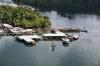
Pearl Factory
| | |
|
Dan Nickens - May 06,2014
Viewers
| Reply
|
| |
Just off the factory the pearls are growing in great lines. Perhaps the oysters are filtration for the local sewage. That would give wearing cultured pearls a whole new scent.
| | Attachments:

Pearl Farm
| | |
|
Dan Nickens - May 06,2014
Viewers
| Reply
|
| |
Not far from the pearl farm was a small fishing village.
| | Attachments:
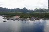
Urban Area
| | |
|
Dan Nickens - May 06,2014
Viewers
| Reply
|
| |
Right in the center of the village was a lovely mosque. You don’t have to guess the local religions. Just find the nicest, largest structure and then you know.
| | Attachments:

Town Center
| | |
|
Dan Nickens - May 06,2014
Viewers
| Reply
|
| |
The bay with 1000 rock temples was all located on the opposite inlet, nicely separated from the village and pearl farm. There was a conveniently located channel to cut through if the locals were inclined to visit. I didn’t see any other boats, though, when exploring the temples.
| | Attachments:
Entrance to Temples
| | |
|
Dan Nickens - May 06,2014
Viewers
| Reply
|
| |
In thick temple territory, there were no good options for a land landing. There was, however, plenty of pretty water around.
| | Attachments:

Rocky Spines
| | |
|
Dan Nickens - May 06,2014
Viewers
| Reply
|
| |
You could easily see the temples from the air, sticking up through the thick trees. I felt like an aerial archeologist uncovering ancient ruins hidden for centuries by the jungle!
| | Attachments:

Lost Temple
| | |
|
Dan Nickens - May 06,2014
Viewers
| Reply
|
Dan Nickens - May 06,2014
Viewers
| Reply
|
| |
You can’t really call the land rough. It’s way beyond that it. With the tall spires, it’s like a wicked wire brush.
| | Attachments:
Spiney Land
| | |
|
Dan Nickens - May 06,2014
Viewers
| Reply
|
| |
This brush clawed up a bunch of greenery.
| | Attachments:

Rock Shrines
| | |
|
Dan Nickens - May 06,2014
Viewers
| Reply
|
| |
The deep blue and shallow turquoise water was woven into the fabric of the brush.
| | Attachments:
Rocky Cove
| | |
|
Dan Nickens - May 06,2014
Viewers
| Reply
|
| |
Imagine trying to hike through this land.
| | Attachments:

Rock Walls
| | |
|
Dan Nickens - May 06,2014
Viewers
| Reply
|
| |
With such sharp relief there are bound to be a few cracks reaching down to the water.
| | Attachments:

Tenuous Connection
| | |
|
Dan Nickens - May 06,2014
Viewers
| Reply
|
| |
Some islands were mostly filled with the razor like ridges and spires.
| | Attachments:

Isle of Razor Rock
| | |
|
Dan Nickens - May 06,2014
Viewers
| Reply
|
| |
You can look at this all day and see something every time. I flew over this six times with different people. It was never boring.
| | Attachments:

Razor Spires
| | |
|
Dan Nickens - May 06,2014
Viewers
| Reply
|
| |
If you like rock wall climbing, a cross-country through this stuff might make for a good workout.
| | Attachments:

Serrated Ridges
| | |
|
Dan Nickens - May 06,2014
Viewers
| Reply
|
| |
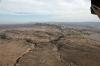
Out on the edges of the templelands the tops got rounder and the water got wider.
| | Attachments:
A Flood of Hills
| | |
|
Dan Nickens - May 06,2014
Viewers
| Reply
|
| |
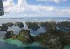
This overview shows one section thick with temples. These photos do the area an injustice. Two of my well traveled passengers concluded this was in the top two places they had seen in the world. I don’t know about that. Each place has its own splendor. I’m saying top five for sure.
| | Attachments:
Swarm of Temples
| | |
|
Dan Nickens - May 06,2014
Viewers
| Reply
|
| |
The really cool thing is that some of the limestone is part of an ancient reef system. Now there is a new one growing on top of it.
| | Attachments:
Coral Lines
| | |
|
Dan Nickens - May 06,2014
Viewers
| Reply
|
| |
As abrupt as some of the temple walls are, the underwater walls are even steeper.
| | Attachments:
Edge of Deep
| | |
|
Dan Nickens - May 06,2014
Viewers
| Reply
|
Dan Nickens - May 06,2014
Viewers
| Reply
|
| |
Look at all the parallel lines.
| | Attachments:
Rock Alleys
| | |
|
Dan Nickens - May 06,2014
Viewers
| Reply
|
| |
At the end of the day there must have been a thousand photos of this stuff. None were the same.
| | Attachments:
Rocky Sentinels
| | |
|
Dan Nickens - May 06,2014
Viewers
| Reply
|
| |
In some places the ridges had dissolved, leaving only lingering towers.
| | Attachments:
Free Temples
| | |
|
Dan Nickens - May 06,2014
Viewers
| Reply
|
| |
This island was a tempting second to my favorite.
| | Attachments:

Beach Apron
| | |
|
Dan Nickens - May 06,2014
Viewers
| Reply
|
Dan Nickens - May 06,2014
Viewers
| Reply
|
| |
Ah, finally on a beach!<br /><br />It wasn’t as idyllic as it looked. Ocean swell refracting around the island made for some rough splashing on landing. Since there was no damage to the airplane, though, it was well worth the effort.<br />
| | Attachments:

Beach Break
| | |
|
Dan Nickens - May 06,2014
Viewers
| Reply
|
| |
Sandra, the chief stewardess, is from Fiji. She is a connoisseur of beautiful island beaches. “Best in the world,” was her assessment. I haven’t seen them all, but this has to rank right up there.
| | Attachments:

Survey Team
| | |
|
Dan Nickens - May 06,2014
Viewers
| Reply
|
| |
Center stage for the vehicle that made it possible to effortlessly explore such a remote, difficult to access area.
| | Attachments:

Survey Vehicle
| | |
|
Dan Nickens - May 06,2014
Viewers
| Reply
|
| |
Rather than take a pounding on takeoff from the island, we taxied in search of some protected water. This rock marked the opening to a quiet cove.
| | Attachments:

Channel Marker
| | |
|
Dan Nickens - May 06,2014
Viewers
| Reply
|
| |
A little cone of an island looking a lot like a Christmas tree.
| | Attachments:

Sitting on Pedestal
| | |
|
Dan Nickens - May 06,2014
Viewers
| Reply
|
| |
The departure cove: a smooth way to leave without testing the strength of the hull.
| | Attachments:

Exit Strategy
| | |
|
Dan Nickens - May 06,2014
Viewers
| Reply
|
| |
Sandra had to get back to work. She went straight to the boss, telling him he had to check out the temples and the island.<br /><br />“Now, let me get this straight: you’ve been on a deserted island with a pilot? Have you no sense? Don’t you know how dangerous they are!”<br /><br />(Sandra probably knows, but she can take care of herself...and she is newly in love with the ship's chef.)<br /><br />Of course he intentionally missed the point. But he did get the message.<br />
| | Attachments:

Back to Base
| | |
|
Don Maxwell - May 07,2014
Viewers
| Reply
|
| |
What would she have to worry about, Dan. 'The pilots' lives were simple and orderly, like those of all men of action.' (Consuelo de Saint-ExupUry, THE TALE OF THE ROSE [1945], Random House Trade Paperback Edition, 2003, 88)
| | |
|
Dan Nickens - May 07,2014
Viewers
| Reply
|
| |
I'm pretty sure he was alluding to the lotharios behavior often attributed to pilots leading disreputable and disorderly lives, Don. I trust the humor he was attempting was based in the antithesis of existent reality.
| | |
|
Don Maxwell - May 07,2014
Viewers
| Reply
|
| |
Sorry, Dan, Consuelo was his wife, writing about him and other pilots. She was probably wrong about a lot of other things, too. She's the rose in his <I>The Little Prince.</I><!-- >'"><br><font color=red size=6>' or > missing in user HTML. Please fix the HTML.</font> -->
| | |
|
Dan Nickens - May 06,2014
Viewers
| Reply
|
| |
It was too late in the day for the guests to make it to the temples or the island. The Captain decided he would change locations for the following day, but not so far away as to prevent return trips to the temples. The morrow he promised would be another chance at showing off this special place.
| | Attachments:

Late to Board
| | |
| | | | | | | | | | | | | | | | | | | | | | | | | | | | | | | | | | | | | | | | | | | | | | | | | | | | | | | | | | | | | | | | | | | | | | | | | | | | | | |