|
|
 |
|
|
|
|
|
|
|
|
|
|
|
|
|

Click on photo to view the original size. |
| Viewers
|
|
|
|
|
|
|
|
|
|
|
Read what others had to say:
|
|
|
|
|
|
|
 |
Nickens, Dan - Nov 14,2018
Viewers
| Reply
|
| |
The new and improved schedule meant missing a local seaplane gathering. It looked like a traffic jam, anyway, with the blue SPA SeaRey waiting offshore in the queue to come ashore.
Tavares, FL
| | Attachments:

1
| | |
|
Nickens, Dan - Nov 14,2018
Viewers
| Reply
|
| |
What help is technology when you still end up with a big headwind? Worst of all it was displayed right on the EFIS where it couldn't be ignored!
Near Williston, FL
| | Attachments:

1
| | |
|
Nickens, Dan - Nov 14,2018
Viewers
| Reply
|
| |
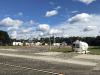
The airfield in Perry is normally quiet. On this day, however, there was plenty of traffic. The reason was obvious when I pulled up to the fuel pump: the fair was in town. And it was parked right next to the airport.
When I went into the office to grab a lunch snack, the manager was too helpful. "Why eat that junk? There is food right next door at the fair."
My experience with fair food is that it is not much less junk than vending food. I took my chances with the prepackaged stuff. Walking back to the plane I noticed the fuel pump sign was missing. Strange.
Perry (40J Foley Field), FL (after 2.3 hours enroute)
| | Attachments:
1
| | |
|
Don Maxwell - Nov 14,2018
Viewers
| Reply
|
| |
The missing sign probably repeated the legend painted on the side of that tank, Dan. That could have lead you to tell a very different legend, indeed.
| | |
|
Nickens, Dan - Nov 14,2018
Viewers
| Reply
|
| |
You haven't heard about the Rotax 994, Don? It's a turboprop. (Maybe someday.)
| | |
|
Nickens, Dan - Nov 14,2018
Viewers
| Reply
|
| |
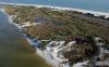
The panhandle coast was looking pretty normal until I came across a foundation without a house at St. Teresa. Pieces of the house were scattered throughout the woods.
Michael. He had come to visit just a few weeks earlier. He brought 155 mph winds, forces comparable to an EF3 tornado, and, worse, storm surge. Sure, he targeted the coast further west, but his swath was wider. This was the first of his victims I spotted (not counting, in retrospect, a missing fuel pump sign).
I hope this was a holiday home used only on bright, windless days, or that the owner was gone far inland when the Michael's hammer hit.
St. Teresa, FL
| | Attachments:
1
| | |
|
Nickens, Dan - Nov 14,2018
Viewers
| Reply
|
| |
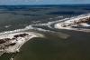
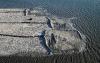
If houses on the mainland were smashed, what chances did houses out on a barrier island have?
Fifty:fifty, judging by these houses. Of course the ones that weren't smashed were offset inland by a few feet. But, as they say in real estate circles, "It's location, location, location."
Dog Island, FL
| | Attachments:

1
| | |
|
Nickens, Dan - Nov 14,2018
Viewers
| Reply
|
| |
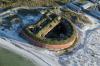
What chance does any house have when the sandy foundation is just swept away?
Dog Island, FL
| | Attachments:

1
| | |
|
Nickens, Dan - Nov 14,2018
Viewers
| Reply
|
| |
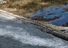
Houses weren't the only thing messed up. Portions of roads were washed away too.
St. George Island, FL
| | Attachments:
1
| | |
|
Nickens, Dan - Nov 14,2018
Viewers
| Reply
|
| |
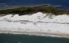
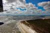
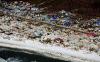
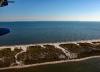
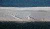
One good thing from the extreme wave washing: the beaches were really clean.
St. George Island, FL
| | Attachments:
1
| | |
|
Nickens, Dan - Nov 14,2018
Viewers
| Reply
|
| |
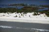
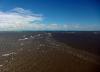
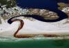
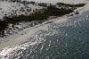
Water colors painted by the wind.
St. Vincent Isand, FL
| | Attachments:
1
| | |
|
Nickens, Dan - Nov 14,2018
Viewers
| Reply
|
| |
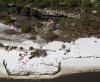
Humans weren't the only ones affected by the storm. Trees lining the shore were stacked against their inland companions.
St. Vincent Island, FL
| | Attachments:

1
| | |
|
Nickens, Dan - Nov 14,2018
Viewers
| Reply
|
| |
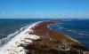
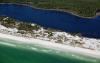
Cape San Blas is a thin strand of sand that stands between the gulf and the coast. It was bulls eye for a direct hit by Hurricane Michael.
Cape San Blas, FL
| | Attachments:
1
| | |
|
Nickens, Dan - Nov 14,2018
Viewers
| Reply
|
| |
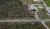
The main road to the outer cape was partially washed out. Fortunately most of the houses on the outer cape looked relatively intact. There was some roof damage, but most (not all) of the houses were intact.
Cape San Blas, FL
| | Attachments:
1
| | |
|
Nickens, Dan - Nov 14,2018
Viewers
| Reply
|
| |
The road to the park portion of the island was completed breached, breaking the cape in half.
Cape San Blas, FL
| | Attachments:
1
| | |
|
Nickens, Dan - Nov 14,2018
Viewers
| Reply
|
| |
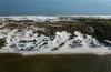
The cape was intact but much of the vegetation was dying or stressed.
Cape San Blas, FL
| | Attachments:
1
| | |
|
Nickens, Dan - Nov 14,2018
Viewers
| Reply
|
| |
The landward side of the cape-protected bay was largely intact. The coast lying outside the cape's protective edge was exposed to the full force of the hurricane's arsenal, offering unimpeded waves.
Cape San Blas, FL
| | Attachments:

1
| | |
|
Nickens, Dan - Nov 14,2018
Viewers
| Reply
|
| |
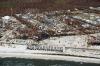
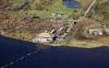
Two weeks after being hit by the hurricane, Mexico Beach was still a disaster. From the looks of it, a lot more time will be required to clean up the mess and start making it anew.
Mexico Beach, FL
| | Attachments:
1
| | |
|
Nickens, Dan - Nov 14,2018
Viewers
| Reply
|
| |
Mexico Beach was old Florida. It was not designed for a hurricane like Michael.
Mexico Beach, FL
| | Attachments:
1
| | |
|
Nickens, Dan - Nov 14,2018
Viewers
| Reply
|
| |
"Gone like yesterday."
Mexico Beach, FL
| | Attachments:

1
| | |
|
Nickens, Dan - Nov 14,2018
Viewers
| Reply
|
| |
Waking up from the nightmare below I saw I was closing in on R2905A & B. Transiting along the coast I had been in contact with Tyndall AFB. I asked if the military restricted area was active. The controller didn't know. That was strange, because the restricted area extends into Tyndall Class D airspace.
Sigh. Well, a sharp turn out to the north over the town was needed. It seemed a bit disrespectful of the situation (a pure fun machine high lording over disaster), but I did it anyway.
Mexico Beach, FL
| | Attachments:

1
| | |
|
Nickens, Dan - Nov 14,2018
Viewers
| Reply
|
| |
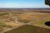
The normally green fields inland of coast are all rust brown because of the massive intrusion of saltwater.
Inland of Mexico, Beach, FL
| | Attachments:
1
| | |
|
Nickens, Dan - Nov 14,2018
Viewers
| Reply
|
| |
Even 3 miles inland large pine trees were snapped in half and structures destroyed. Not from surge. From wind.
East Bay, near Tyndall Air Force Base, FL
| | Attachments:
1
| | |
|
Nickens, Dan - Nov 14,2018
Viewers
| Reply
|
| |
Military jets were not immune to the storm's rampage.
Tyndall Air Force Base, FL
| | Attachments:

1
| | |
|
Don Maxwell - Nov 14,2018
Viewers
| Reply
|
| |
Tsk. A Hammacher-Schlemmer jet with Walmart Tiedowns.
| | |
|
Nickens, Dan - Nov 14,2018
Viewers
| Reply
|
| |
How much wind does it take to blow over a 28,000 pound windsock? Maybe the better question is how much water does it take?
| | |
|
Nickens, Dan - Nov 14,2018
Viewers
| Reply
|
| |
The trees lined up in fallen rows.
Tyndall Air Force Base, FL
| | Attachments:
1
| | |
|
Nickens, Dan - Nov 14,2018
Viewers
| Reply
|
| |
Is it any wonder the controller at Tyndall was unconcerned about the status of surrounding airspace? He had plenty to focus on in his own neighborhood.
There were expensive F-22s parked on the apron. News reports said that much of the frontline fighter fleet based at Tyndall was unable to escape before the storm.
Tyndall Air Force Base, FL
| | Attachments:

1
| | |
|
Nickens, Dan - Nov 14,2018
Viewers
| Reply
|
| |
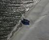
Boats were scattered around the bay. Some large, some small. Some ashore, some sunken. Some almost just staying afloat.
East Bay, near Parker, FL
| | Attachments:

1
| | |
|
Nickens, Dan - Nov 14,2018
Viewers
| Reply
|
| |
Some of the wrecks just defied reason.
Panama City, FL
| | Attachments:

1
| | |
|
Nickens, Dan - Nov 14,2018
Viewers
| Reply
|
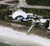
| |
Oh the devastation! The swimming pool has turned brown from storm surge. The house seems unaffected, but it may have just arrived from outer space.
Near Phillips Inlet, Panama City Beach, FL
| | Attachments:
1
| | |
|
Nickens, Dan - Nov 14,2018
Viewers
| Reply
|
| |
Can't blame Michael for the brown leakage. It was there before he came ashore.
Near Seagrove Beach, FL
| | Attachments:
1
| | |
|
Nickens, Dan - Nov 14,2018
Viewers
| Reply
|
| |
Natural areas located west of Michael's impact appeared unstressed by the close encounter. With some trepidation I stopped at Destin (KDTS) for fuel after 3.1 hours of flight. There was no evidence of Michael's visit, but my favorite FBO (on the south end) had changed ownership. It seemed a bit more formal and less accommodating that the last time I visited. Nothing bad. Not unfriendly. Just less friendly. Maybe it was residual stress from the storm?
Or maybe it was then new owner. But change happens. Sigh. I flew on west.
Near Miramar Beach, FL
| | Attachments:
1
| | |
|
Nickens, Dan - Nov 14,2018
Viewers
| Reply
|
| |
Gulf Shores was hosting an AOPA regional fly in. It was the last day and there was a mass evacuation in progress. As an uncontrolled field, there was little method to the departures. All I could do was go low to get away from the busy buzzing hive.
Low was fine, even if it was a national wildlife refuge. As the name implied, Bon Secour, was a safe haven for a lonely SeaRey avoiding the larger, predatory fowl from the Jack Edwards airport. I wasn't too worried about disturbing migrating song birds either. It was late in their season. They should have already passed to the south.
Bon Secour National Wildlife Refuge, AL
| | Attachments:
1
| | |
|
Nickens, Dan - Nov 14,2018
Viewers
| Reply
|
| |
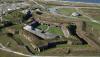
After the war of 1812 Fort Morgan was constructed on the east side of the entrance to Mobile Bay to protect the shipping channel. It saw action in the Civil War when the Confederates battled Captain Farragut's assault force as they forced their way into the bay. After being hammered by the fort's obsolete guns, Farragut was trapped, unable to proceed against withering fire. With anchored torpedoes on the west side, and highly effective canon fire on the east, Farragut decided to try to run through the torpedoes. "Damn the torpedoes! Full speed ahead!" is the famous quote attributed to him.
The actual quote was less incisive. He told his pilot to pick his way through the torpedoes and to go ahead at full speed. Which had the same effect as the famous quote, without the drama.
Fortunately for Farragut, most of the torpedoes were water logged and ineffective. He only lost one ironclad, but escaped into the bay where he had to hang out until the fort could be neutralized by a land assault. The story was spun to make his lucky escape a heroic victory. And it's a good story, but nuanced as most are.
Fort Morgan, AL
| | Attachments:
1
| | |
|
Nickens, Dan - Nov 14,2018
Viewers
| Reply
|
| |
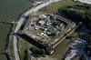
At the opposite side to the bay entrance sits Fort Gaines. It was supposed to provide protection to shallow draft boats running the blockade that didn't need to use the deep channel. When faced with a federal assault, the commander of the fort and his staff decided it was hopeless and gave up without a fight. As history shows, the entire Confederate effort was doomed to failure, so it seems they were right. Nowadays it's used for historical reenactments (Battles without casualties? That shouldn't offend even childish sensibilities.)
Fort Gaines, AL
| | Attachments:
1
| | |
|
Nickens, Dan - Nov 14,2018
Viewers
| Reply
|
| |
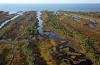
Out on the western, undeveloped end of the island, recent channels could clearly be seen. How many more storms will it take to cut a channel?
Dauphin Island, AL
| | Attachments:
1
| | |
|
Nickens, Dan - Nov 14,2018
Viewers
| Reply
|
| |
Wave sculpting on the (now) low energy beach.
Dauphin Island, AL
| | Attachments:
1
| | |
|
Nickens, Dan - Nov 14,2018
Viewers
| Reply
|
| |
On an unnamed sandy island rests a boat load of sand.
Near Petit Bois Island
| | Attachments:
1
| | |
|
Nickens, Dan - Nov 14,2018
Viewers
| Reply
|
| |
This boat appeared not so much abandoned as badly parked.
Horn Island
| | Attachments:

1
| | |
|
Nickens, Dan - Nov 14,2018
Viewers
| Reply
|
| |
A wild part of the Gulf Shores National Seashore.
Horn Island
| | Attachments:
1
| | |
|
Nickens, Dan - Nov 14,2018
Viewers
| Reply
|
| |
A slightly weedy part of the sand strands.
Horn Island
| | Attachments:
1
| | |
|
Nickens, Dan - Nov 14,2018
Viewers
| Reply
|
| |
Loss of integrity.
Horn Island
| | Attachments:

1
| | |
|
Nickens, Dan - Nov 14,2018
Viewers
| Reply
|
| |
Whatever it was, it is no more.
Horn Island
| | Attachments:

1
| | |
|
Nickens, Dan - Nov 14,2018
Viewers
| Reply
|
| |
The white sand brilliantly reflected the low sun.
Horn Island, MS
| | Attachments:

1
| | |
|
Nickens, Dan - Nov 14,2018
Viewers
| Reply
|
| |
It may be a small topographic rise, but it's enough relief to support development of drainage channels.
Ship Island, MS
| | Attachments:
1
| | |
|
Nickens, Dan - Nov 14,2018
Viewers
| Reply
|
| |
What to do when your island washes apart in the middle? Call in the Corpse of Engineers! This is how you build an island, China!
Ship Island, MS
| | Attachments:
1
| | |
|
Nickens, Dan - Nov 14,2018
Viewers
| Reply
|
| |
At first it seemed these boat people were investigating the wreck of a sailboat. Upon closer examination, however, they were proclaiming "Chucky is gay". Maybe. I'm not good at reading Sandscript.
West Ship Island, MS
| | Attachments:

1
| | |
|
Nickens, Dan - Nov 14,2018
Viewers
| Reply
|
| |
If covering the fort with grass was an attempt at camouflage, well, it didn't work. No worries, though, as the fort is now protected by the Corpse of Engineers who pump sand on it to strengthen it against the sea.
Fort Massachusetts, West Ship Island, MS
| | Attachments:
1
| | |
|
Nickens, Dan - Nov 14,2018
Viewers
| Reply
|
| |
Pointed end of Ship Island.
West Ship Island, MS
| | Attachments:

1
| | |
|
Nickens, Dan - Nov 14,2018
Viewers
| Reply
|
| |
The quiet back waters of Cat Island are haunted by raccoons and alligators. Early French explorers thought the raccoons were cats and thus the name. I guess they didn't see the alligators. Too bad, cause Dragon Island would be a lot more melodramatic.
Cat Island, MS
| | Attachments:
1
| | |
|
Nickens, Dan - Nov 14,2018
Viewers
| Reply
|
| |
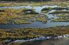
The strange ways of Cat Islands include north-south beaches and a western marsh and swamp. It was shaped by currents that no longer flow thanks to dredging of ship channels.
Cat Island, MS
| | Attachments:

1
| | |
|
Nickens, Dan - Nov 14,2018
Viewers
| Reply
|
| |
Katrina's 30' storm surge swamped most of Bay St. Louis. Now they have grass barriers. Good luck with that.
The good luck for me was an evening in Slidell, Louisiana (KASD) after 8.4 hours of sometimes sobering flight. (569 sm at an average ground speed of 68 mph).
Bay St. Louis, MS
| | Attachments:

1
| |
| Attachments:
1
| | |
|
|
|
|
|
|
|
|
|
|
|
| |
- About Searey.us -
- Contact Searey.us -
|
- Privacy Statement -
- Terms of service -
|
Copyright © 2024 Searey.us & Brevard Web Pro, Inc. -
Copyrights may also be reserved
by posters and used by license on this site. See Terms of Service for more information.
|
| |
- Please visit our NEW
Chapter Place Website at: chapterplace.com or
Free Chapter Management Website at: ourchapter.org. Good for all chapters, groups or families. |
| | | | | | | | | | | | | | | | | | | | | | | | | | | | | | | | | | | | | | | | | | | | | | | | |