|
|
 |
|
|
|
|
|
|
|
|
|
|
|
 Favorite option: If you want this item to be marked as a favorite, click on the black heart.
Fine Friends (Reunion Flight, End of Days)
Favorite option: If you want this item to be marked as a favorite, click on the black heart.
Fine Friends (Reunion Flight, End of Days) |
|
Make Cover Photo
Clear Cover Photo
|
|

Click on photo to view the original size. |
| Viewers
|
|
|
|
|
|
|
|
|
|
|
Read what others had to say:
|
|
|
|
|
|
|
 |
Nickens, Dan - Oct 21,2018
Viewers
| Reply
|
| |
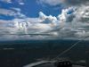
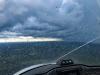
It didn't take long to find the first storm. It was already heading from the gulf towards the airport.
East of Houma, LA
| | Attachments:

First Puff IMG 7757
| | |
|
Nickens, Dan - Oct 21,2018
Viewers
| Reply
|
| |
My original plan was to follow the coastline east until I ran into storms. It was the shortest route. That went out in the first few minutes of the flight. The storms were already moving ashore. It would have been the shortest cross country flight ever.
Mississippi River South of New Orleans
| | Attachments:
Marching Ashore IMG 7764
| | |
|
Nickens, Dan - Oct 21,2018
Viewers
| Reply
|
| |
It was early enough and cool enough in the early morning that there shouldn't be monster storms. Indeed, most of the rain shafts were isolated, falling from pretty short stacks. That would have been encouraging except that the heat of the day, fuel for the monsters, was still coming.
South of New Orleans, LA
| | Attachments:
Less than Towering IMG 7768
| | |
|
Nickens, Dan - Oct 21,2018
Viewers
| Reply
|
| |
With only isolated storms, it was easy enough at first to navigate away from them.
Mississippi Delta, LA
| | Attachments:
Easily Avoided IMG 3348
| | |
|
Nickens, Dan - Oct 21,2018
Viewers
| Reply
|
| |
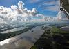
What with figuring how to avoid flying into New Orleans airspace and avoid thunderstorms, there wasn't much time to consider what I was flying over. When I did, it was pretty nice (if you like that kinda stuff).
Mississippi Delta Marshes, LA
| | Attachments:

Marshlands IMG 7783
| | |
|
Nickens, Dan - Oct 21,2018
Viewers
| Reply
|
| |
A wall to keep Mother Nature out.
Trigger for a flashback:
"Hey! What gives you the right?"
"To put up a fence to keep me out or to keep mother nature in"
"If God was here he'd tell you to your face, man, you're some kinda sinner"
from the Five Man Electric Band.
At least the wall wasn't keeping me out.
Mississippi Delta, LA
| | Attachments:

Hardline IMG 7787
| | |
|
Nickens, Dan - Oct 21,2018
Viewers
| Reply
|
| |
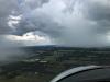
The storms were already moving onshore and approaching Stennis International. I asked the controller if I could borrow some of his airspace to go around them. With a few vectors to stay out of his approach lane, he said come on through.
SW of Stennis International Airport, MS
| | Attachments:

Inland Turn IMG 7799
| | |
|
Nickens, Dan - Oct 21,2018
Viewers
| Reply
|
| |
The longer I flew, the more the storms pushed me inland. Well, if I couldn't get to Florida, maybe New York?
West of Gulfport, MS
| | Attachments:
Not Direct IMG 3350
| | |
|
Nickens, Dan - Oct 21,2018
Viewers
| Reply
|
| |
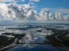
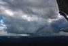
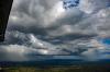
There was no thought of stopping and letting the storms blow through. The radar showed they were massively mustering offshore for what looked to be a long term assault of the land.
NW of Gulfport, MS
| | Attachments:
Deeper Diversion IMG 3351
| | |
|
Nickens, Dan - Oct 21,2018
Viewers
| Reply
|
| |
With storms on the rampage, there was no time to stop and explore strange river sand patterns.
Pascagoula River, West of Agricola
| | Attachments:

Sand Waves IMG 7821
| | |
|
Nickens, Dan - Oct 21,2018
Viewers
| Reply
|
| |
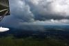
From high to low, a wall of water and clouds. Now that's a wall for a little airplane. (Oh, I know. Divert.)
Southern Alabama
| | Attachments:
Vertical Coverage IMG 7815
| | |
|
Nickens, Dan - Oct 21,2018
Viewers
| Reply
|
| |
And then the storms were starting to pop up inland too. With ground fog. That was new. Probably it wouldn't be long until I just picked a spot and parked it for the day.
Near Stockton, AL
| | Attachments:
Ground Clouds IMG 7844
| | |
|
Nickens, Dan - Oct 21,2018
Viewers
| Reply
|
| |
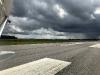
With all the maneuvering around storms, I stopped to take on fuel north of the storms. It had been 2.8 hours of evasive flight and I was nowhere near clear. After searching and finally finding the self service tank I barely had time to get out.
(Oh, no, I didn't consider just parking it at Atmore for the day. Have you ever been to Atmore? If so, you might have just blinked and missed it.)
Atmore, AL
| | Attachments:
Close Approach IMG 3359
| | |
|
Nickens, Dan - Oct 21,2018
Viewers
| Reply
|
| |
You know you're cutting it too close when the windscreen starts weeping.
East of Atmore, AL
| | Attachments:
Cutting it Close IMG 3363
| | |
|
Nickens, Dan - Oct 21,2018
Viewers
| Reply
|
| |
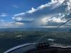
As if there weren't enough clouds in the sky, someone had the great idea of adding smoke to the mix. I made it to Bainbridge, Georgia to find the eastern edge to the storms covering the Florida panhandle. It now looked like an avenue might be open towards home. Not gonna stop now!
Near of Geneva, AL
| | Attachments:

Another Complication IMG 7872
| | |
|
Nickens, Dan - Oct 21,2018
Viewers
| Reply
|
| |
With less water in the sky to worry about, I could start looking for the good water down low to splash. This wasn't good water.
Lake Iamonia, FL
| | Attachments:

Channelization IMG 7900
| | |
|
Nickens, Dan - Oct 21,2018
Viewers
| Reply
|
| |
Definitely not good for splashing.
Near Ingalla Field (FL12) , Miccouski, FL
| | Attachments:

Covered Water IMG 7903
| | |
|
Nickens, Dan - Oct 21,2018
Viewers
| Reply
|
| |
Even with no water it would be a good emergency field tucked in between miles of pine forest.
Near Ingalla Field (FL12) , Miccouski, FL
| | Attachments:

Break in the Pines IMG 7904
| | |
|
Nickens, Dan - Oct 21,2018
Viewers
| Reply
|
| |
What manner of forestry is this, with square patches of grass between the pines?
Near Erider, FL
| | Attachments:

Strange Forrestry IMG 7911
| | |
|
Don Maxwell - Oct 21,2018
Viewers
| Reply
|
| |
That is a strange one, Dan. Did you ever find out what was going on there?
| | |
|
Nickens, Dan - Oct 21,2018
Viewers
| Reply
|
| |
No, I have no idea, Don. That doesn’t mean I won’t ignorantly speculate. There are countless acres of thickly planted trees. Then
there’s this. Maybe it’s a pine straw plantation. Would wider spacing make it easier to collect the straw? Maybe. But the straw
looks a lot thicker out in the traditional forests.
| | |
|
Nickens, Dan - Oct 21,2018
Viewers
| Reply
|
| |
It was too much to ask that all the storms clear a path for home. They were back. And now the problem was I was in Florida. Too close to stop. I had get-home-itis.
Near Mayo, FL
| | Attachments:

Rain Returns IMG 7924
| | |
|
Nickens, Dan - Oct 21,2018
Viewers
| Reply
|
| |
The stress of fighting storms was just too much. A river break was needed and taken.
Suwannee River Near Old Town, FL
| | Attachments:

Weather Break IMG 3371
| | |
|
Nickens, Dan - Oct 21,2018
Viewers
| Reply
|
| |
A break in the rain cells was a tempting shortcut this close to home, but what's a few extra minutes to stay dry?
Near Ocala, FL
| | Attachments:
Possible Shortcut IMG 7953
| | |
|
Nickens, Dan - Oct 21,2018
Viewers
| Reply
|
| |
The reward for not washing the airplane was a nice rainbow at the edge of the storm.
Near Ocala, FL
| | Attachments:

Double Reward IMG 7973
| | |
|
Nickens, Dan - Oct 21,2018
Viewers
| Reply
|
| |
With the afternoon getting late and closing on home, it was just too tempting to take shortcut. Should I? No. Did I? Well, first I needed to consult the GPS
Near Ocala, FL
| | Attachments:
Too Tempting IMG 3377
| | |
|
Nickens, Dan - Oct 21,2018
Viewers
| Reply
|
| |
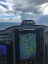
The GPS was putting up yellow and red warnings about the possible shortcut. The windscreen told a different story. I went with what I saw.
Near Ocala, FL
| | Attachments:

Unbelievable IMG 3378
| | |
|
Nickens, Dan - Oct 21,2018
Viewers
| Reply
|
| |
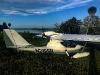
My old shipmate from SuRi took me across the continent without one word of complaint. Though it was only 3.4 hours from the last stop, Bainbridge. For the day, the total was 8.4 hours of bopping and weaving, covering 550 nm (about 630 sm), for an average of 76 mph. That was the end of 5 "work" days and 43 fine flying hours from Washington.
It sealed a decision. I'd happily have N219SR back in my life. Now, what could I do to induce him to sell her? Hmmm, well, there was a squawk list. There wasn't anything serious on it, but who knows. It could make an ignorant purchaser decide to back out if there was an eager option. I shot it off with a hope and a prayer.
No luck. The new owner was smarter than that.
Okay, one last gambit. When the list of squawks, sniveling complaints, and picky improvement were being done at the factory, I went to PA. "Now, here's the plan," I confided. "You tell the owner that the repairs will cost $40,000 because the airplane sucks. I'll pay for lunch." Well, I knew where the door was. They didn't have to show it to me. Sigh.
Well, at least now I know this great example of the species will be going to an appreciative owner. And I'll be ready if he changes his mind.
Howey in the Hills, FL
| | Attachments:
Happily Back Home IMG 3385
| |
| Attachments:

Flight Path Day 5
| | |
|
Bill West - Oct 21,2018
Viewers
| Reply
|
| |
Thanks Dan for the traveling pictures, narrative, and short story. Great adventure. Your life is full of them. I was with you on Friday
as I bobbed and weaved my way from Winder Ga to Gator field. This trip started Thursday morning in Troy Michigan. 32 degrees at
takeoff with no heater. My knees were shaking so bad coming over Lake Erie, I think it was rocking the plane. Thankfully I had a
blanket. A balmy 35 degrees leaving London Ky Friday. 8 hours later, after picking my way thru that front in Ga, home to almost 90.
I thought I had a cold trip until I talked with a gent flying an open Stearman biplane in Waycross Ga. He told me he had left Grand
Rapids Mi Thursday and had followed right behind me the entire trip. Man must be part eskimo. Happy flying Dan.
| | |
|
Nickens, Dan - Oct 21,2018
Viewers
| Reply
|
| |
My pleasure, Bill, but this flight was completed at very comfortable temperatures.
It may be that I was saved from your cold experience when my flight to take a Searey to Seattle today got only as far as Georgia
before it was turned around due to a chilling forecast in the great Northwest.
| | |
|
Britt Holstein - Oct 23,2018
Viewers
| Reply
|
| |
Dan,
Thanks for the story, pictures, and, most of all, advice on beginning this Searey adventure. I've waited
35 years to bring a
seaplane to my house but you will be the first to know if I ever decide to move on to something else.
You're welcome to
stop in and see N219SR any time you're near Lake Murray, SC.
| | Attachments:

Searey Sunset
| | |
|
Bill West - Oct 26,2018
Viewers
| Reply
|
| |
Hi Britt, Congratulations on your new bird. Beautiful place you have to fly. I sold my first Searey to a gent in Lexington. He flys
out of a fly_in community with a grass strip just SW of there. I flew it up there and spent a couple days flying Lake Murray with
him. Maybe you two can meet up. Happy flying.
| | |
|
Britt Holstein - Oct 28,2018
Viewers
| Reply
|
| |
Thanks Bill. Is the buyer of your Searey a member here?
| | |
|
Bill West - Oct 29,2018
Viewers
| Reply
|
| |
Sorry Britt, I gave him the info and contacts to join but have never seen him on the sites. His name is Jimmy Berry and he flys
out of Gilbert Field. Check the Unicom frequency for there and you can chat when you see him. Every Searey owner shud take
advantage of the wealth of info on the sites.
| | |
|
Ken Leonard - Oct 28,2018
Viewers
| Reply
|
| |
Britt - go to the technical site, go to file cabinet and open the searey locator file. It tells you where everyone is. You can search on
your state. If you have trouble, call me at 813-416-7744.
| | |
|
Don Maxwell - Oct 28,2018
Viewers
| Reply
|
| |
Correction, Ken. The Searey Locator is a great resource, and I wish everyone were listed in it. Unfortunately, that's not the case. It includes only those who have asked John Dunlop to include them. Also, John can remove only those he hears from or about, so it lists some people who no longer have a Searey or who are dead. And it doesn't include most who have bought factory-built Seareys because PA doesn't tell them about STS. (Or didn't while Adam was there.)
What's worse--I think--is that many recent members of STS are listed as living on Merritt Island instead of wherever they really do live. I suspect that has something to do with the new way of joining STS by clicking on a link that visitors to Splash and Dash see, but that is invisible to members.
| | |
|
Ken Leonard - Oct 24,2018
Viewers
| Reply
|
| |
Welcome Britt! What Dennis said.
| | |
|
Dennis Scearce - Oct 24,2018
Viewers
| Reply
|
| |
Welcome to the family, Britt. Up here in the Carolinas, we always WUFF.
| | |
|
Nickens, Dan - Oct 23,2018
Viewers
| Reply
|
| |
That is a beautiful location and picture, Britt. Congratulations on achieving long term dream in such spectacular fashion.
| | |
|
Don Maxwell - Oct 23,2018
Viewers
| Reply
|
| |
Congratulations, Britt! You couldn't have chosen a better seaplane to grace Lake Murray than a Searey. You'd have to look hard to find a finer lake than Murray, too. I've splashed down in it several times on the inland route between Virginia and Florida and was never in a hurry to move on.
| | |
|
|
|
|
|
|
|
|
|
|
|
| |
- About Searey.us -
- Contact Searey.us -
|
- Privacy Statement -
- Terms of service -
|
Copyright © 2024 Searey.us & Brevard Web Pro, Inc. -
Copyrights may also be reserved
by posters and used by license on this site. See Terms of Service for more information.
|
| |
- Please visit our NEW
Chapter Place Website at: chapterplace.com or
Free Chapter Management Website at: ourchapter.org. Good for all chapters, groups or families. |
| | | | | | | | | | | | | | | | | | | | | | | | | | | | | | | | | | | |