|
|
 |
|
|
|
|
|
|
|
|
|
|
|
|
|

Click on photo to view the original size. |
| Viewers
|
|
|
|
|
|
|
|
|
|
|
Read what others had to say:
|
|
|
|
|
|
|
 |
Nickens, Dan - Oct 18,2018
Viewers
| Reply
|
| |
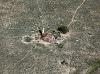
The land wasn't the only thing that was flat. This old home was flattened.
Near the Corona VOR, NM 9/22.
| | Attachments:
Flat Roof IMG 1002
| | |
|
Nickens, Dan - Oct 17,2018
Viewers
| Reply
|
| |
Out in the desert it takes time for things to fall apart. The electrical service seems to indicate this place wasn't abandoned so long ago.
Near the Corona VOR, NM 9/22
| | Attachments:
Not Long Gone IMG 1005
| | |
|
Nickens, Dan - Oct 17,2018
Viewers
| Reply
|
| |
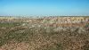
The land looked a bit crusty. I dropped lower to see if it might be caliche, crusty calcium deposits that often forms in deserts. Maybe, but the dirty gray patches were biological, not chemical. Still, the white areas? The only way to know for sure would be to stop. I didn't have time for that.
Near the Corona VOR, NM 9/22
| | Attachments:
Mottled Land IMG 1015
| | |
|
Nickens, Dan - Oct 17,2018
Viewers
| Reply
|
Nickens, Dan - Oct 17,2018
Viewers
| Reply
|
| |
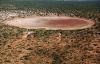
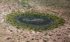
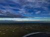
A playa lake just waiting for the thunderstorms out east to leak over this way.
North of Pecos River, NM 9/22
| | Attachments:
Waiting for Water IMG 1043
| | |
|
Nickens, Dan - Oct 17,2018
Viewers
| Reply
|
| |
It seemed as I inched towards the east and closer to the stalled front, the ponds got wetter.
North of Pecos River, NM 9/22
| | Attachments:
Almost Wet IMG 1051
| | |
|
Nickens, Dan - Oct 17,2018
Viewers
| Reply
|
Nickens, Dan - Oct 17,2018
Viewers
| Reply
|
| |
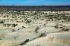
The beautiful old beach sand was lying below the Mescalero Ridge (escarpment) marking the start of the great Llano Estacado on the horizon.
East of Roswell, NM 9/22
| | Attachments:
Beach Below IMG 1077
| | |
|
Nickens, Dan - Oct 17,2018
Viewers
| Reply
|
| |
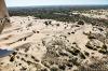
Rolling over the dunes, just like on some deserted coastline. The Mescalero Sands are named after the Mescalero Apache who once roamed the desert coast.
East of Roswell, NM 9/22
| | Attachments:

Rolling with Sand IMG 1089
| | |
|
Nickens, Dan - Oct 17,2018
Viewers
| Reply
|
| |
If you squint just so you can imagine the darker vegetation as an ocean sweeping against the old sandy beach.
East of Roswell, NM 9/22
| | Attachments:
Imaginary Shoreline IMG 1093
| | |
|
Nickens, Dan - Oct 17,2018
Viewers
| Reply
|
| |
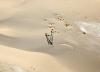
The sand is slowly burying recent intruders.
East of Roswell, NM 9/22
| | Attachments:
Slow Burial IMG 1100
| | |
|
Nickens, Dan - Oct 17,2018
Viewers
| Reply
|
| |
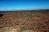
Climbing up onto the great Llano Estacado, one of the largest tablelands on the North American Continent.
East of Roswell, NM 9/22
| | Attachments:
Flatlining IMG 1105
| | |
|
Nickens, Dan - Oct 17,2018
Viewers
| Reply
|
| |
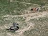
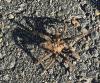
You don't mess around at desert fueling stations. You never know what may slither or crawl out from under the pump. This tarantula was not happy at being disturbed.
But, I needed fuel for the last stretch, so I stopped at Lovington, NM (E06) because they had self-service fuel. I wanted just a little reserve because night was coming and there had been weather at my destination in west Texas. In 2.6 hours the flight log covered 228 miles at about 88 mph.
Lovington NM (E06) 3295 9/22
| | Attachments:
Pump Protector IMG 3295
| | |
|
Nickens, Dan - Oct 17,2018
Viewers
| Reply
|
| |
Tablelands are flat. The Llano Estacado is exceptionally flat: sloping a mere 10' per mile towards the southeast. That's the direction I was headed, so at least it was downhill.
There wasn't much to look at. When surveyed by General Randolph Marcy in 1852, he had a rather pessimistic assessment: "When we were upon the high table-land, a view presented itself as boundless as the ocean. Not a tree, shrub, or any other object, either animate or inanimate, relieved the dreary monotony of the prospect; it was a vast-illimitable expanse of desert prairie .... the great Sahara of North America. It is a region almost as vast and trackless as the ocean—a land where no man, either savage or civilized permanently abides ... a treeless, desolate waste of uninhabitable solitude, which always has been, and must continue uninhabited forever."
Apparently he didn't realize there was water and oil below his feet.
Llano Estacado, NM 9/22
| | Attachments:
Flatout IMG 1117
| | |
|
Nickens, Dan - Oct 17,2018
Viewers
| Reply
|
| |
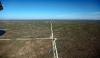
With as little as 14" of rain annually there wouldn't seem to be enough water to grow a scrawny cactus. Fortunately for the farmers there is an underground reservoir: the prodigious Ogallala Aquifer. Unfortunately that is a dwindling resource, forcing some farmers to resort to dryland farming or growing oil.
SE of Hobbs, NM 9/22
| | Attachments:
Growing Disks 2 IMG 1123
| | |
|
Nickens, Dan - Oct 17,2018
Viewers
| Reply
|
| |
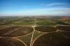
The other underground resource that buggered General Marcy's assessment was oil. It occurs in abundance below the Llano Estacado, hiding in the productive Permian Basin (so named because it has one of the world's thickest deposits of sediment from the Permian Period). It is the largest petroleum producing basin in the U.S., currently providing more than 1 million barrels of oil per day for SeaReys everywhere. Production is forecast to increase to 5.4 million barrels per day by 2023, so balls to the wall! Fly on!
Approaching Odessa, TX 9/22
| | Attachments:

Black Crops IMG 1125
| | |
|
Nickens, Dan - Oct 17,2018
Viewers
| Reply
|
| |
Well, fly on unless there is nasty weather ahead. There was. A front stalled for days over Texas, and extending to the mid-Atlantic states was now dead ahead. But it was a problem for another day. I stopped at Odessa (KODO) for the evening.
Approaching Odessa, TX 9/22
| | Attachments:
Stop Ahead IMG 3304
| | |
|
Nickens, Dan - Oct 17,2018
Viewers
| Reply
|
| |
After another 1.2 hours covering only 94 miles I was down with the sun. I wasn't the only one stuck for the night. This guy was stuck on a stick.
For the day, about 660 miles flown in 9.2 hours. Not a blistering speed, but enough to catch up with the bad weather.
Odessa (KODO), Texas 9/22
| | Attachments:

Stuck on Stick IMG 3307
| | |
|
|
|
|
|
|
|
|
|
|
|
| |
- About Searey.us -
- Contact Searey.us -
|
- Privacy Statement -
- Terms of service -
|
Copyright © 2024 Searey.us & Brevard Web Pro, Inc. -
Copyrights may also be reserved
by posters and used by license on this site. See Terms of Service for more information.
|
| |
- Please visit our NEW
Chapter Place Website at: chapterplace.com or
Free Chapter Management Website at: ourchapter.org. Good for all chapters, groups or families. |
| | | | | | | | | | | | | |