|
|
 |
|
|
|
|
|
|
|
|
|
|
|
|
|

Click on photo to view the original size. |
| Viewers
|
|
|
|
|
|
|
|
|
|
|
Read what others had to say:
|
|
|
|
|
|
|
 |
Nickens, Dan - Oct 07,2018
Viewers
| Reply
|
| |
What's not always clear is that there is enough soft water available for an uneventful emergency landing.
Snake River Near Bowmont, ID 9/21
| | Attachments:
Shallow Snake 9432
| | |
|
Nickens, Dan - Oct 07,2018
Viewers
| Reply
|
| |
Almost Flat
The top of the river canyon was a mostly flat old lava flow. It might be bumpy, but perhaps a bit better choice for an emergency landing than the lumpy river. Less elevation to hike out of anyway.
Snake River Canyon NE of Murphy, ID 9/21
| | Attachments:

Almost Flat IMG 9434
| | |
|
Nickens, Dan - Oct 07,2018
Viewers
| Reply
|
| |
Up Canyon
Looking into the distance there was smoke from distant fires on the horizon. After getting a jump on the wet northwest weather, this portended to be a day for dealing with dry weather hazards.
Snake River Canyon NE of Murphy, ID 9/21
| | Attachments:
Up Canyon IMG 9451
| | |
|
Nickens, Dan - Oct 07,2018
Viewers
| Reply
|
| |
Wire Trap
Nothing ruins a relaxed flight up river like wires flashing in the early morning light.
Snake River north of Oreana, ID 9/21
| | Attachments:

Wire Trap IMG 9452
| | |
|
Don Maxwell - Oct 08,2018
Viewers
| Reply
|
| |
Iron spider.
| | |
|
Nickens, Dan - Oct 07,2018
Viewers
| Reply
|
| |
Hypnotizing Fields
Don't stare at the fields too long! You could get hypnotized and miss the wires.
North of Oreana, ID 9/21
| | Attachments:

Hypnotizing Fields IMG 9466
| | |
|
Nickens, Dan - Oct 07,2018
Viewers
| Reply
|
| |
Smoking Water
Smoke on the water! Fire up in the sky?
No matter what we get out of this
I know I'll never forget
Near Grand View, ID 9/21
| | Attachments:
Smoking Water IMG 9474
| | |
|
Nickens, Dan - Oct 07,2018
Viewers
| Reply
|
| |
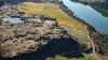
Safety Stop
When there's smoke, fires, wires and general mayhem abounding, standing down for safety seemed to be the prudent thing to do. Though the water didn't appear on SPA's known list for approved landing areas, with no one around there's no one to care, right?
C.J. Strike Reservoir, ID 9/21
| | Attachments:
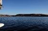
Safety Stop IMG 9484
| | |
|
Nickens, Dan - Oct 07,2018
Viewers
| Reply
|
| |
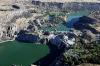
Lake Slopes
The lakeshore wasn't particularly compatible with preserving the scratch free hull the new owner bargained for, so I flew on.
C.J. Strike Reservoir, ID 9/21
| | Attachments:
Lake Slopes IMG 9494
| | |
|
Nickens, Dan - Oct 07,2018
Viewers
| Reply
|
| |
Fall on the Flats
Where the lakeshore was flatter, colors of fall were seeping into the scenery.
C.J. Strike Reservoir, ID 9/21
| | Attachments:

Fall on the Flats IMG 9509
| | |
|
Nickens, Dan - Oct 07,2018
Viewers
| Reply
|
| |
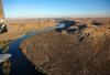
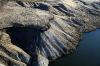
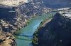
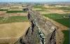
Sheer Lava
Where the river cuts sharply and deeply, layers of lava are steeply exposed.
SE of Mountain Home AFB, ID 9/21
| | Attachments:
Sheer Lava IMG 9519
| | |
|
Nickens, Dan - Oct 07,2018
Viewers
| Reply
|
| |
Ghostly Sprinkles
The early morning sun caught the sprinkles moving ghostlike across the fields.
Near Glenns Ferry, ID 9/21
| | Attachments:

Ghostly Sprinkles IMG 9537
| | |
|
Nickens, Dan - Oct 07,2018
Viewers
| Reply
|
| |
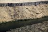
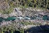
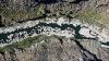
Rough River
The river got really shallow and narrow near Hagerman. The area was home to ancient horses and camels before the Ice Age. Later on the Oregon Trail went through too. Looked mighty rough for whoever or whatever might be passing at ground level.
Near the Hagerman Fossil Beds National Monument, ID 9/21
| | Attachments:
Rough River IMG 9555
| | |
|
Nickens, Dan - Oct 07,2018
Viewers
| Reply
|
| |
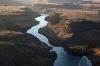
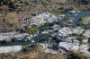
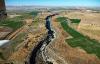
One of 1000
Water seeped and surged from the black walled canyons. There is a Thousand Springs State Park along the river, but who's counting. Water running down the mountains far to the north gets caught up in the Eastern Snake Plain Aquifer, a jumble of broken lava rocks, which swallows whole rivers before being dumped into the canyon or sucked out from farmer wells.
Near Hagerman, ID 9/21
| | Attachments:
One of 1000 IMG 9557
| | |
|
Nickens, Dan - Oct 07,2018
Viewers
| Reply
|
| |
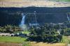
Fields Fit In
Sometimes there is room in river valley to squeeze in some fields down by the river.
Near Hagerman, ID 9/21
| | Attachments:
Fields Fit In IMG 9561
| | |
|
Nickens, Dan - Oct 07,2018
Viewers
| Reply
|
| |
Crossing the Snake
It's legal to base jump the 486' to the river from the Perrine Bridge. Not sure what the law would say about a seaplane landing under it.
Twin Falls, ID 9/21
| | Attachments:
Crossing the Snake IMG 9584
| | |
|
Nickens, Dan - Oct 07,2018
Viewers
| Reply
|
| |
Little Falling
Not much water was falling at the twin falls.
Twin Falls, ID 9/21
| | Attachments:
Little Falling IMG 9600
| | |
|
Nickens, Dan - Oct 07,2018
Viewers
| Reply
|
Nickens, Dan - Oct 07,2018
Viewers
| Reply
|
| |
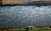
White Water
Just a bit of water in little white rush.
Near Burley, ID 9/21
| | Attachments:
White Water IMG 9611
| | |
|
Nickens, Dan - Oct 07,2018
Viewers
| Reply
|
| |
High Balls
The scenery is great for sightseeing as long as you keep the pretty balls in sight. They aren't obvious, but they are there for anyone looking.
Near Burley, ID 9/21
| | Attachments:
High Balls IMG 9631
| | |
|
Nickens, Dan - Oct 07,2018
Viewers
| Reply
|
| |
Deeply Cut
Just like slicing butter? Who knew lava rock could be carved so easily with a little water!
Snake River near Burley, ID 9/21
| | Attachments:
Deeply Cut IMG 9633
| | |
|
Nickens, Dan - Oct 07,2018
Viewers
| Reply
|
| |
Cuts Both Ways
The river cuts into the lava plain for a long ways to the south and east, then back to the west and north again.
Snake River near Burley, ID 9/21
| | Attachments:
Cuts Both Ways IMG 9644
| | |
|
Nickens, Dan - Oct 07,2018
Viewers
| Reply
|
| |
Open Spaces
I have no idea what will become of a building with such open spaces!
I did know that after reaching Burley, Idaho in 2.7 morning hours of overwhelming scenery it was going to be a long, good day.
In the AOPA on-line magazine this week there is story about an Icon flight from California to the east coast. It was done mostly above the clouds. It seems to have been a much shorter trip (in standard time, whereas in SeaRey time the relativistic clock was just racing by at jet speed for me).
Near Burley, ID 9/21
| | Attachments:

AOPA Iconic Article
| |
| Attachments:
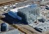
Open Spaces IMG 9656
| | |
|
Dave Edward - Oct 08,2018
Viewers
| Reply
|
| |
Spectacular pics and the narrative isn't too shabby as well. Thanks you Dan for showing us the ' overwhelming ' scenery.
Couple of questions: Any idea how big the irrigation circles are ? I used to think that the ones near Moses Lake were big..
Were the Ghostly Sprinkles a flock or a reflection? Were the High Balls charted ?
Looking forward to the next posting. Thank You !
| | |
|
Nickens, Dan - Oct 08,2018
Viewers
| Reply
|
| |
Okay, here we go, Dave,
1. The irrigation circles are HUGE! It took me ten minutes to cross one in the SeaRey. Oh. Wait. That's my selective apparent SeaRey speed. Well, maybe they weren't really that huge. Just for example, the hypnotizing crop circles were about half a mile in diameter. That's not even thirty seconds to cross in nonrelativistic SeaRey time.
2. The ghostly sprinkles were irrigation water sprayed from fixed sprinkler heads. The water just glowed in the direct sunlight of early morning. Double click on the photo and you can see the ghastly detail.
3. Yes, the High Balls were charted. The only ones that snuck up on me were the baby ones strung down low.
| | |
|
Don Maxwell - Oct 08,2018
Viewers
| Reply
|
| |
Dan, it's good to know that those high balls are charted. The big problem, of course, is that one would have to study the charts before flying--or else pay close attention to a GPS app in the cockpit that was able to display them in a helpful way. Having balls on wires is probably a more reliable way to keep pilots alive because it doesn't require an intermediary. But lighting wires up like neon signs their whole length would make me a lot happier. I still have nightmares about uncharted un-balled wires materializing directly in front of my Searey at about 800 ft AGL over the Ohio River.
| | |
|
Nickens, Dan - Oct 08,2018
Viewers
| Reply
|
| |
In addition to the charts, I've found it helps to visualize where people setting wire traps would place them, Don. If there is a hunting shack across a small river from a farm, watch out! Hunters aren't as rough and tough as they used to be. Now they need electricity to make their Starbucks brand mocha latte out in the boondocks!
| | |
|
Don Maxwell - Oct 08,2018
Viewers
| Reply
|
| |
Yeah, around here (central Virginia) if there's an island in a river, expect a wire, probably 10 or 15 feet above the water, with no visible poles or towers. Where we live, the James River is dotted with duck blinds, but fortunately the river is wide enough that none of them have wires running to them. (Yet.) On the morning of our recent splash-in, some hunter was blasting away about half a mile upstream with what sounded like an automatic shotgun--3 or 4 rounds at a time. Fortunately, he stopped shooting when planes started showing up. But then he probably went to Home Depot for a few hundred yards of extension cord.
| | |
|
|
|
|
|
|
|
|
|
|
|
| |
- About Searey.us -
- Contact Searey.us -
|
- Privacy Statement -
- Terms of service -
|
Copyright © 2024 Searey.us & Brevard Web Pro, Inc. -
Copyrights may also be reserved
by posters and used by license on this site. See Terms of Service for more information.
|
| |
- Please visit our NEW
Chapter Place Website at: chapterplace.com or
Free Chapter Management Website at: ourchapter.org. Good for all chapters, groups or families. |
| | | | | | | | | | | | | | | | | | | | | | | |